Country:
 Réunion
Region:
City:
Latitude and Longitude:
Time Zone:
Postal Code:
IP information under different IP Channel
ip-api
Country
Region
City
ASN
Time Zone
ISP
Blacklist
Proxy
Latitude
Longitude
Postal
Route
IPinfo
Country
Region
City
ASN
Time Zone
ISP
Blacklist
Proxy
Latitude
Longitude
Postal
Route
MaxMind
Country
Region
City
ASN
Time Zone
ISP
Blacklist
Proxy
Latitude
Longitude
Postal
Route
Luminati
Country
RECity
saintdenis
ASN
Time Zone
Indian/Reunion
ISP
TELCO-OI-AS
Latitude
Longitude
Postal
db-ip
Country
Region
City
ASN
Time Zone
ISP
Blacklist
Proxy
Latitude
Longitude
Postal
Route
ipdata
Country
Region
City
ASN
Time Zone
ISP
Blacklist
Proxy
Latitude
Longitude
Postal
Route
Popular places and events near this IP address
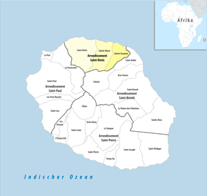
Arrondissement of Saint-Denis, Réunion
Arrondissement in Réunion, France
Distance: Approx. 6155 meters
Latitude and longitude: -20.88277778,55.44861111
The arrondissement of Saint-Denis is an arrondissement of France in the Réunion department in the Réunion region. It has three communes. Its population is 204,304 (2016), and its area is 287.8 km2 (111.1 sq mi).

Stade Jean-Ivoula
Distance: Approx. 1102 meters
Latitude and longitude: -20.895,55.50138889
The Stade Jean-Ivoula, colloquially known as Stade de l'Est, is a multi-use stadium in Saint-Denis, Réunion. It is currently used mostly for football matches. The stadium holds 7,500.
Sainte-Marie, Réunion
Commune in Réunion, France
Distance: Approx. 4895 meters
Latitude and longitude: -20.8969,55.5492
Sainte-Marie (French pronunciation: [sɛ̃t maʁi] ) is a commune in the French overseas department of Réunion. It is located on the north side of the island of Réunion, just east of, and adjacent to, the capital of Saint-Denis.
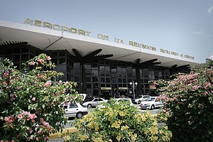
Roland Garros Airport
Airport in Réunion
Distance: Approx. 2164 meters
Latitude and longitude: -20.89,55.51638889
Roland Garros Airport (French: Aéroport de la Réunion Roland Garros) (IATA: RUN, ICAO: FMEE), formerly known as Gillot Airport, is located in Sainte-Marie on Réunion, France. The airport is 7 kilometres (3.8 NM) east of Saint-Denis; it is named after the French aviator Roland Garros, who was born in Saint-Denis.

Jardin de l'État
Distance: Approx. 5752 meters
Latitude and longitude: -20.88666667,55.45111111
The Jardin de l'État, formerly known as the Jardin du Roy, is a historic botanical garden on the island of Réunion, found in the capital Saint-Denis. Planted with trees and spices taken from outside the island by Pierre Poivre, the garden is home to a natural history museum opened in August 1855. The garden was built from 1767 to 1773.

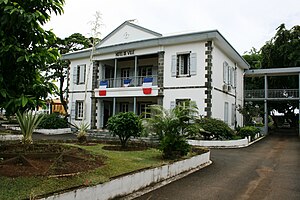
Roman Catholic Diocese of Saint-Denis de La Réunion
Latin Catholic diocese in Réunion
Distance: Approx. 6011 meters
Latitude and longitude: -20.88305556,55.45
The Diocese of Saint-Denis de La Réunion (Latin: Dioecesis Sancti Dionysii Reunionis; French: Diocèse de Saint-Denis de La Réunion) is a Latin Church ecclesiastical jurisdiction or diocese of the Catholic Church located on the island of Réunion. It is immediately subject to the Holy See. As such, it is not part of an ecclesiastical province, but is a member of the Episcopal Conference of the Indian Ocean (with Comoros, Mauritius and Seychelles).
Domenjod
Distance: Approx. 999 meters
Latitude and longitude: -20.91305556,55.50666667
Domenjod is a neighbourhood on the island of Réunion, located on its northern coast. On the left bank of the Rivière des Pluies, it depends on the commune of Saint-Denis.
La Mare, Reunion
Town
Distance: Approx. 3966 meters
Latitude and longitude: -20.88333333,55.53333333
La Mare is a small town in Réunion on the north coast. It lies to the east of the capital St-Denis.

Rivière des Pluies
River in Réunion, France
Distance: Approx. 2453 meters
Latitude and longitude: -20.88277778,55.50222222
The Rivière des Pluies is a river on the Indian Ocean island of Réunion. It flows to the sea on the island's northern shore, between the communes of Saint-Denis and Sainte-Marie. It is 18.5 km (11.5 mi) long.

Ravine du Chaudron
River in Réunion, France
Distance: Approx. 2428 meters
Latitude and longitude: -20.8837,55.497
Ravine du Chaudron is a river in Réunion. It is 14.8 km (9.2 mi) long. It flows into the Indian Ocean near Saint-Denis.
Canton of Sainte-Marie
Distance: Approx. 4932 meters
Latitude and longitude: -20.91,55.55
The canton of Sainte-Marie is an administrative division of Réunion, an overseas department and region of France. Its borders were not modified at the French canton reorganisation which came into effect in March 2015. Its seat is in Sainte-Marie.
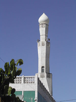
Noor-e-Islam Mosque
Mosque in Saint-Denis, Réunion
Distance: Approx. 5969 meters
Latitude and longitude: -20.87925,55.45244444
The Noor-e-Islam Mosque (French: Mosquée Noor-e-Islam) is a mosque in Saint-Denis, Réunion.
Weather in this IP's area
few clouds
21 Celsius
20 Celsius
20 Celsius
21 Celsius
1024 hPa
66 %
1024 hPa
1016 hPa
10000 meters
5.14 m/s
140 degree
20 %
06:12:16
18:12:48