Country:
 Indonesia
Region:
City:
Latitude and Longitude:
Time Zone:
Postal Code:
IP information under different IP Channel
ip-api
Country
Region
City
ASN
Time Zone
ISP
Blacklist
Proxy
Latitude
Longitude
Postal
Route
IPinfo
Country
Region
City
ASN
Time Zone
ISP
Blacklist
Proxy
Latitude
Longitude
Postal
Route
MaxMind
Country
Region
City
ASN
Time Zone
ISP
Blacklist
Proxy
Latitude
Longitude
Postal
Route
Luminati
Country
IDRegion
bt
City
tangerang
ASN
Time Zone
Asia/Jakarta
ISP
Linknet ASN
Latitude
Longitude
Postal
db-ip
Country
Region
City
ASN
Time Zone
ISP
Blacklist
Proxy
Latitude
Longitude
Postal
Route
ipdata
Country
Region
City
ASN
Time Zone
ISP
Blacklist
Proxy
Latitude
Longitude
Postal
Route
Popular places and events near this IP address
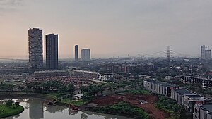
Tangerang
Largest city of Banten, Indonesia
Distance: Approx. 1513 meters
Latitude and longitude: -6.17027778,106.64027778
Tangerang (Sundanese: ᮒᮍᮨᮛᮀ, Indonesian pronunciation: [taˈŋəɾaŋ]) is a largest city in the province of Banten, Indonesia. Located on the western border of Jakarta, it is the sixth largest city proper in the nation; and the largest city in Banten province. It has an area of 164.55 km2 (63.53 sq mi) and an official 2010 Census population of 1,798,601, which had risen to 1,895,486 at the 2020 Census – making it the eighth most populated suburb in the world at the latter date; the official estimate as at mid 2023 was 1,912,679 - comprising 961,354 males and 951,325 females.

Batuceper
Town and district in Banten, Indonesia
Distance: Approx. 6085 meters
Latitude and longitude: -6.1656824,106.682188
Batuceper is a district of Tangerang City, Banten, Indonesia. It formed part of the particuliere land, or private domain, of Luitenant der Chinezen Tan Tiang Po and his son, Tan Liok Tiauw Sia, Landheeren or landlords of Batoe-Tjepper.

Swiss German University
Sponsored university
Distance: Approx. 6150 meters
Latitude and longitude: -6.22552222,106.65496944
Swiss German University (SGU) is a privately sponsored university and located at Alam Sutera, a community in Tangerang, Banten, Indonesia. Swiss German University was established in the year 2000 as a joint effort between private investors from Germany and Indonesia. Nowadays, it is run by an Indonesian businessman.
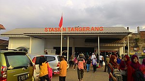
Tangerang railway station
Railway station in Indonesia
Distance: Approx. 509 meters
Latitude and longitude: -6.1769,106.633
Tangerang Station (Indonesian: Stasiun Tangerang) is a railway station located in the city of Tangerang, Banten. It is the western terminus of the Duri–Tangerang railway. This station only serves commuter trains operated by Kereta Commuter Indonesia.

Pelita Harapan University
Private university in Indonesia
Distance: Approx. 6129 meters
Latitude and longitude: -6.2292,106.6108
Pelita Harapan University (Indonesian: Universitas Pelita Harapan, UPH) is a private Reformed Evangelical coeducational higher education institution run by the Pelita Harapan Education Foundation (Indonesian: Yayasan Pendidikan Pelita Harapan) in Lippo Village, Tangerang, Banten, Indonesia. It was founded in 1993 and is part of the Lippo Group. UPH was the first university in Indonesia to introduce programs entirely taught in English, the first to offer a liberal arts curriculum, and the first to introduce a multi-disciplinary approach to its programs.

Benteng Heritage Museum
Museum in Banten, Indonesia
Distance: Approx. 234 meters
Latitude and longitude: -6.1786869,106.6296684
The Benteng Heritage Museum (Indonesian: Museum Benteng Heritage) is a heritage site and museum in Pasar Lama, the old market district in Tangerang, Banten, Indonesia. Located near the river Cisadane, it is the first Indonesian museum that highlights the history and heritage of ethnic Chinese in Indonesia. Benteng Heritage Museum is housed in a traditional, vernacular Peranakan Chinese building.

Kali Pasir Mosque
Mosque in Tangerang, Banten, Indonesia
Distance: Approx. 253 meters
Latitude and longitude: -6.17922222,106.62886111
The Kali Pasir Mosque (Indonesian: Masjid Kali Pasir) is the oldest mosque in Tangerang city, a relic of Pajajaran Kingdom. It is located in Cisadane riverbank, in the middle of Chinese residential and is characterized by it Chinese pattern.

SHIA railway station
Railway station in Indonesia
Distance: Approx. 6120 meters
Latitude and longitude: -6.127382,106.652205
SHIA Station or Soekarno–Hatta International Airport Station (BST) (Indonesian: Stasiun Bandara Soekarno–Hatta) is a station for Soekarno–Hatta Airport Rail Link service. The station is located between Skytrain station of Terminal 1 and Terminal 2 of Soekarno–Hatta International Airport. This station serves airport passengers going to Batu Ceper Station, Duri Station, BNI City Station, to Manggarai Station.
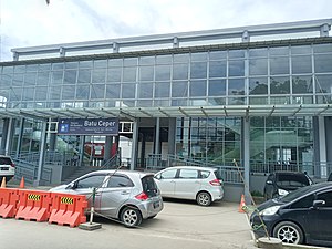
Batu Ceper railway station
Railway station in Indonesia
Distance: Approx. 4096 meters
Latitude and longitude: -6.172205,106.665093
Batu Ceper Station (BPR) (Indonesian: Stasiun Batu Ceper) is a railway station located at Poris Plawad, Cipondoh, Tangerang, Indonesia. Although named as Batu Ceper, but the location of this station is not in the district of Batuceper, rather it is located at Cipondoh district of Tangerang. The station serves Greater Jakarta commuter rail and Soekarno–Hatta Airport Rail Link.

Poris railway station
Railway station in Indonesia
Distance: Approx. 5765 meters
Latitude and longitude: -6.1699387,106.6800057
Poris Station (PI) is a class III railway station located in Poris Gaga, Batuceper, Tangerang. The station, which is located at an altitude of +7 meters, is included in the Jakarta Operational Area I, is the easternmost train station in Tangerang, and only serves the KRL Commuterline route.

Al-Azhom Grand Mosque
Mosque in Tangerang, Banten, Indonesia
Distance: Approx. 1419 meters
Latitude and longitude: -6.16984276,106.6390134
Al-Azhom Grand Mosque (Indonesian: Masjid Raya Al-A'zhom) is a congregational mosque in the city of Tangerang, Banten, Indonesia. Opened in 2003, it is the largest mosque in Banten province and one of the largest mosques in the world in terms of the worshipper capacity.
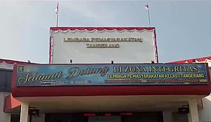
Tangerang prison fire
2021 fire near Jakarta, Indonesia
Distance: Approx. 1699 meters
Latitude and longitude: -6.18666667,106.64027778
On 8 September 2021, a fire occurred in an overcrowded prison block in the city of Tangerang, Banten, Indonesia, in Greater Jakarta. The fire began at about 01:45 WIB (18:45 UTC, 7 September) in sector C of the Tangerang prison, killing 41 inmates and injuring a further 75. More victims succumbed to their injuries in the following days, raising the death toll to 49.
Weather in this IP's area
few clouds
29 Celsius
31 Celsius
29 Celsius
31 Celsius
1011 hPa
56 %
1011 hPa
1009 hPa
10000 meters
2.57 m/s
180 degree
20 %
05:44:37
17:50:04