139.255.116.226 - IP Lookup: Free IP Address Lookup, Postal Code Lookup, IP Location Lookup, IP ASN, Public IP
Country:
Region:
City:
Location:
Time Zone:
Postal Code:
ISP:
ASN:
language:
User-Agent:
Proxy IP:
Blacklist:
IP information under different IP Channel
ip-api
Country
Region
City
ASN
Time Zone
ISP
Blacklist
Proxy
Latitude
Longitude
Postal
Route
db-ip
Country
Region
City
ASN
Time Zone
ISP
Blacklist
Proxy
Latitude
Longitude
Postal
Route
IPinfo
Country
Region
City
ASN
Time Zone
ISP
Blacklist
Proxy
Latitude
Longitude
Postal
Route
IP2Location
139.255.116.226Country
Region
papua barat daya
City
sorong
Time Zone
ISP
Language
User-Agent
Latitude
Longitude
Postal
ipdata
Country
Region
City
ASN
Time Zone
ISP
Blacklist
Proxy
Latitude
Longitude
Postal
Route
Popular places and events near this IP address

Sorong
City and capital of Southwest Papua, Indonesia
Distance: Approx. 1852 meters
Latitude and longitude: -0.86666667,131.25
Sorong is the largest city and the capital of the Indonesian province of Southwest Papua. The city is located on the western tip of the island of New Guinea with its only land borders being with Sorong Regency. It is the gateway to Indonesia's Raja Ampat Islands, species rich coral reef islands in an area considered the heart of the world's coral reef biodiversity.

Domine Eduard Osok Airport
Airport serving Sorong, Southwest Papua, Indonesia
Distance: Approx. 4494 meters
Latitude and longitude: -0.89416667,131.28888889
Domine Eduard Osok Airport (IATA: SOQ, ICAO: WASS), located in Sorong, Southwest Papua, Indonesia, is one of the largest and busiest airports on the Bird's Head Peninsula. It replaced a smaller, former World War II airfield, Jefman Airport on the island of Jefman. The airport is named after Domine Eduard Osok, a pastor originating from Sorong and known for doing missionary work and spreading Christianity in Sorong and the surrounding parts.

Sorong Regency
Regency in Southwest Papua, Indonesia
Distance: Approx. 27 meters
Latitude and longitude: -0.88305556,131.25
Sorong Regency (Indonesian: Kabupaten Sorong) is a regency of the Southwest Papua province of Indonesia. It covers an area of 13,075.28 km2, and had a population of 70,619 at the 2010 Census, and 118,679 at the 2020 Census; the official estimate as of mid-2023 was 129,963 (comprising 68,564 males and 61,399 females). Its administrative centre is the town of Aimas.
Sapta Ratna Pagoda
Distance: Approx. 2146 meters
Latitude and longitude: -0.87905556,131.26880556
The Sapta Ratna Pagoda is a Chinese pagoda in Sorong, Southwest Papua province, Indonesia. Each month about 7,000 locals and foreigners visit the pagoda. The Sapta Ratna Pagoda was built in the late 1990s.

Doom Island
Island in Southwest Papua, Indonesia
Distance: Approx. 1598 meters
Latitude and longitude: -0.88694444,131.23611111
Doom Island (Indonesian: Pulau Doom or Pulau Dum, pronounced "Dom") is a small island in Southwest Papua, Indonesia. It is administratively part of the city of Sorong, specifically the Sorong Islands District. The island served as an administrative center of Dutch East Indies administration in Papua, and continued to become the core of Sorong for some time before the city developed across the strait on the mainland of Papua.

Soop (Southwest Papua)
Island in Southwest Papua, Indonesia
Distance: Approx. 5615 meters
Latitude and longitude: -0.89,131.2
Soop, also known as Sop or Tsiof, is an island in Southwest Papua province of Indonesia, located in the north of Sele Strait, and off the northwestern coast of the Bird's Head Peninsula. It lies at a distance of about 4 kilometres (2.5 mi) west of the city of Sorong on the mainland, 2.5 kilometres (1.6 mi) west of the island of Doom, 3 kilometres (1.9 mi) northwest of the uninhabited island of Nana, 6 kilometres (3.7 mi) north-east of the island of Yefman, and 5 kilometres (3.1 mi) south of the island of Raam. Soop is 3.3 kilometres (2.1 mi) long and up to 1.3 kilometres (0.81 mi) wide, with an area of 2.67 square kilometres (1.03 sq mi).

Raam (Southwest Papua)
Island in West Papua, Indonesia
Distance: Approx. 6441 meters
Latitude and longitude: -0.838,131.214
Raam, also spelt Ram, is an island in Southwest Papua province of Indonesia, located off the northwestern tip of the Bird's Head Peninsula of New Guinea. It lies at a distance of about 2 kilometres (1.2 mi) from the coast of the city of Sorong (of which it is administratively part), and about 5 kilometres (3.1 mi) north of the islands of Doom and Soop (or Tsiof). About 1.6 kilometres (0.99 mi) long and up to 0.5 kilometres (0.31 mi) wide, Raam has an area of 0.5 square kilometres (0.19 sq mi).

Southwest Papua
Province with special status in Indonesia
Distance: Approx. 1852 meters
Latitude and longitude: -0.86666667,131.25
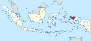
Southwest Papua (Indonesian: Papua Barat Daya) is the 38th province of Indonesia to be created, and was split off from West Papua on 8 December 2022. Despite being named southwest, it is a misnomer and this province is actually located in the northwest edge of Papua. The province comprises the Greater Sorong area (Indonesian: Sorong Raya) which consists of Sorong City, Sorong Regency, South Sorong Regency, Maybrat Regency, Tambrauw Regency, and Raja Ampat Regency.
Weather in this IP's area
overcast clouds
27 Celsius
29 Celsius
27 Celsius
27 Celsius
1008 hPa
80 %
1008 hPa
1007 hPa
10000 meters
1.22 m/s
1.47 m/s
73 degree
100 %