139.177.139.13 - IP Lookup: Free IP Address Lookup, Postal Code Lookup, IP Location Lookup, IP ASN, Public IP
Country:
Region:
City:
Location:
Time Zone:
Postal Code:
IP information under different IP Channel
ip-api
Country
Region
City
ASN
Time Zone
ISP
Blacklist
Proxy
Latitude
Longitude
Postal
Route
Luminati
Country
ASN
Time Zone
America/Chicago
ISP
QTS-SUW1-ATL1
Latitude
Longitude
Postal
IPinfo
Country
Region
City
ASN
Time Zone
ISP
Blacklist
Proxy
Latitude
Longitude
Postal
Route
IP2Location
139.177.139.13Country
Region
illinois
City
chicago
Time Zone
America/Chicago
ISP
Language
User-Agent
Latitude
Longitude
Postal
db-ip
Country
Region
City
ASN
Time Zone
ISP
Blacklist
Proxy
Latitude
Longitude
Postal
Route
ipdata
Country
Region
City
ASN
Time Zone
ISP
Blacklist
Proxy
Latitude
Longitude
Postal
Route
Popular places and events near this IP address

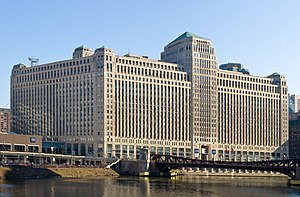
Merchandise Mart
Commercial building in Chicago, Illinois, USA
Distance: Approx. 33 meters
Latitude and longitude: 41.8884,-87.6355
The Merchandise Mart (or the Merch Mart, or the Mart) is a commercial building in downtown Chicago, Illinois. When it opened in 1930, it was the world's largest building, with 4 million square feet (372,000 m2) of floor space. The Art Deco structure is at the junction of the Chicago River's branches.

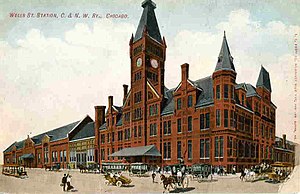
Wells Street Station
Demolished train station in Chicago, Illinois
Distance: Approx. 24 meters
Latitude and longitude: 41.88858,-87.63493
Wells Street Station was a passenger terminal of the Chicago and North Western Railway, located at the southwest corner of Wells Street and Kinzie Street in Chicago, Illinois. It was replaced in 1911 by the Chicago and North Western Terminal on the other (west) side of the North Branch of the Chicago River, removing passenger trains from the Kinzie Street railroad bridge over the river. The Merchandise Mart opened in 1930 on the land formerly occupied by the station.

LaSalle Street Tunnel
Chicago's second traffic tunnel, completed on July 4th, 1871, Designed by William Bryson
Distance: Approx. 235 meters
Latitude and longitude: 41.88755556,-87.6325
The LaSalle Street Tunnel was Chicago's second traffic tunnel under the Chicago River. It was started November 3, 1869, and completed July 4, 1871. It was designed by William Bryson who was the resident engineer for the Washington Street Tunnel.

Merchandise Mart station
Chicago "L" station
Distance: Approx. 99 meters
Latitude and longitude: 41.888675,-87.633966
Merchandise Mart is a station on the Chicago Transit Authority's 'L' system, located in the Near North Side neighborhood at 350 North Wells Street in Chicago, Illinois (directional coordinates 320 north, 200 west). The station is elevated above street level, on a steel structure. The turnstiles and customer assistant booth of the station are located on the second level of the Merchandise Mart itself.

Franklin Street Bridge
Bridge in Chicago, Illinois, U.S.
Distance: Approx. 145 meters
Latitude and longitude: 41.88722222,-87.63583333
The Franklin–Orleans Street Bridge, commonly known as the Franklin Street Bridge, is a bascule bridge over the Chicago River, in Chicago, Illinois, United States. It was built in October 1920, and is located directly southwest of the Merchandise Mart. Connecting the Near North Side with "The Loop," is at the junction of the branches of the river, lying directly west of the Wells Street Bridge.
The Chicago School
Private university with its main campus in Chicago, Illinois, United States
Distance: Approx. 111 meters
Latitude and longitude: 41.888302,-87.633767
The Chicago School is a private university with its main campus in Chicago, Illinois. Established in 1979, The Chicago School was primarily focused on the professional application of psychology. It currently has about 6,000 students across all campuses and online.

Wells Street Bridge (Chicago)
Bridge in Chicago, Illinois, U.S.
Distance: Approx. 142 meters
Latitude and longitude: 41.8875,-87.63388889
The Wells Street Bridge is a bascule bridge over the Chicago River, in downtown Chicago, Illinois, United States, which was built in 1922. Standing east of the Franklin Street Bridge and southeast of the Merchandise Mart, the bridge connects the Near North Side with "The Loop". The bridge is double-decked, the lower deck carrying three lanes of traffic south over the river with sidewalks on both sides of the street.

300 North LaSalle
60-story mixed-use skyscraper in Chicago
Distance: Approx. 167 meters
Latitude and longitude: 41.8882,-87.6331
300 North LaSalle is a 60-story mixed-use building, constructed from 2006 to 2009, located on the north bank of the Chicago River on the Near North Side community area of Chicago, Illinois, United States. The building contains 1.3 million square feet (121,770 square meters) of space to include offices, retail shops, restaurants and public spaces, as well as three levels of underground parking. Due to its location on the north bank of the Chicago River, the building features a half-acre sunlit waterfront public garden with direct access to the river's edge.

350 North Orleans
Building in Chicago
Distance: Approx. 194 meters
Latitude and longitude: 41.887726,-87.637263
350 North Orleans (formerly known as River North Point) is the official name of the 24-floor multipurpose building located in the River North community area of Chicago, at the intersection of the North Branch and the Main Branch of the Chicago River. It was designed by Skidmore, Owings & Merrill. In 1988, Helmut Jahn designed an enclosed pedestrian walking bridge over Orleans Street connecting the building to Merchandise Mart.
Wolf Point East Tower
Skyscraper in Chicago
Distance: Approx. 171 meters
Latitude and longitude: 41.8875,-87.63677778
Wolf Point East Tower is the second tallest of three buildings being developed in the Near North Side community area on the Wolf Point property at a fork in the Chicago River in downtown Chicago. The building is planned to be approximately 60 stories and 660 feet (201.2 m) tall. It will have 698 units.

International Association of Lighting Designers
Distance: Approx. 235 meters
Latitude and longitude: 41.8904,-87.6342
The International Association of Lighting Designers (IALD) is a learned society of architectural lighting designers founded in 1969 and based in Chicago.

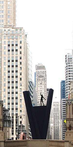
Crossing (sculpture)
Public artwork in Chicago, Illinois, U.S.
Distance: Approx. 214 meters
Latitude and longitude: 41.88858333,-87.63252778
Crossing is a sculpture by Hubertus Von Der Goltz, installed on La Salle Street in Chicago, Illinois. The 25-foot-tall steel artwork has a statue of a man on top of a V-shaped structure. Installed in 1998, it is the only extant permanent work from the 17th annual International Sculpture Conference hosted by Chicago.
Weather in this IP's area
overcast clouds
2 Celsius
-2 Celsius
1 Celsius
3 Celsius
1028 hPa
77 %
1028 hPa
1006 hPa
10000 meters
4.63 m/s
10 degree
100 %
