Country:
Region:
City:
Latitude and Longitude:
Time Zone:
Postal Code:
IP information under different IP Channel
ip-api
Country
Region
City
ASN
Time Zone
ISP
Blacklist
Proxy
Latitude
Longitude
Postal
Route
Luminati
Country
Region
06
City
honefoss
ASN
Time Zone
Europe/Oslo
ISP
Globalconnect As
Latitude
Longitude
Postal
IPinfo
Country
Region
City
ASN
Time Zone
ISP
Blacklist
Proxy
Latitude
Longitude
Postal
Route
db-ip
Country
Region
City
ASN
Time Zone
ISP
Blacklist
Proxy
Latitude
Longitude
Postal
Route
ipdata
Country
Region
City
ASN
Time Zone
ISP
Blacklist
Proxy
Latitude
Longitude
Postal
Route
Popular places and events near this IP address

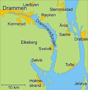
Røyken
Municipality in Buskerud, Norway
Distance: Approx. 5862 meters
Latitude and longitude: 59.73361111,10.42888889
Røyken is a district and village (bygd) and a former municipality in Buskerud in Viken County, Norway. In 2020 Røyken was merged with the municipalities of Hurum and Asker to form the new Asker Municipality (informally called "Greater Asker") located in the newly formed Viken county. The administrative centre of the municipality is the village of Midtbygda.

Oscarsborg Fortress
Coastal fortress in the Oslofjord, Norway
Distance: Approx. 6159 meters
Latitude and longitude: 59.67361111,10.60666667
Oscarsborg Fortress (Norwegian: Oscarsborg festning) is a coastal fortress in the Oslofjord, close to the town of Drøbak in Akershus County, Norway. The best known part is situated on two small islets: Nordre Kaholmen and Søndre Kaholmen. In addition, the main artillery batteries were on the island Håøya and smaller batteries were on the mainland to the west and east of the fjord.

Sætre, Asker
Village in Østlandet, Norway
Distance: Approx. 2558 meters
Latitude and longitude: 59.67972222,10.5175
Sætre is a village in Asker municipality in Akershus county, Norway. Sætre is situated on the western bank of the Inner Oslofjord, approximately 45 kilometers south of Oslo. Sætre was the administrative centre of the former municipality of Hurum in Buskerud between 2012 and 1 January 2020.
Fagerstrand
Village in Østlandet, Norway
Distance: Approx. 5949 meters
Latitude and longitude: 59.73333333,10.6
Fagerstrand is a village in the municipality of Nesodden, in the county of Akershus, in the country of Norway. It is south of Oslo on the peninsula of Nesodden. Fagerstrand has 1977 inhabitants (2006) making it the second largest village on Nesodden.

Battle of Drøbak Sound
Battle of World War II in the Norwegian Campaign
Distance: Approx. 4463 meters
Latitude and longitude: 59.7009,10.5927
The Battle of Drøbak Sound took place in Drøbak Sound, the northernmost part of the outer Oslofjord in southern Norway, on 9 April 1940. It marked the end of the "Phoney War" and the beginning of World War II in Western Europe. A German fleet led by the cruiser Blücher was dispatched up the Oslofjord to begin the German invasion of Norway, with the objective of seizing the Norwegian capital of Oslo and capturing King Haakon VII and his government.

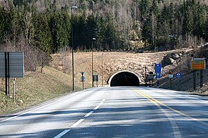
Oslofjord Tunnel
Road tunnel in Frogn and Hurum, Norway
Distance: Approx. 7014 meters
Latitude and longitude: 59.66472222,10.61305556
The Oslofjord Tunnel (Norwegian: Oslofjordtunnelen) is a subsea road tunnel which traverses the Oslofjord, connecting Hurum and Frogn in Norway. Carrying three lanes, the 7,306-meter (23,970 ft) long tunnel reaches a depth of 134 meters (440 ft) below mean sea level. The tunnel has a maximum gradient of seven percent.

Båtstø
Village in Buskerud, Norway
Distance: Approx. 1577 meters
Latitude and longitude: 59.71666667,10.51666667
Båtstø is a small village in Asker municipality in Akerhus county. The village is situated along the Oslofjord between Åros and Nærsnes in Røyken. The distance to Drammen is about 24 km and to Oslo about 38 km.

Åros
Village in Buskerud, Norway
Distance: Approx. 465 meters
Latitude and longitude: 59.70527778,10.50694444
Åros is a village in Røyken in Asker municipality in Akershus county, Norway. The population of Åros (2020) is about 2137.

Nærsnes
Human settlement in Norway
Distance: Approx. 6392 meters
Latitude and longitude: 59.76,10.51
Nærsnes is a village in Røyken in Asker municipality in Akershus, Norway. It is located along the Oslofjord between Båtstø and Slemmestad. As of 2003, it is considered a part of the Greater Oslo area.
Håøya, Akershus
Distance: Approx. 3203 meters
Latitude and longitude: 59.6969,10.5692
Håøya is an island in Oslofjorden in Frogn municipality, Norway. Its area is 5.6 km², which makes it the largest island in Inner Oslo Fjord. It is located between Oscarsborg and Gråøya.

German cruiser Blücher
Admiral Hipper-class cruiser
Distance: Approx. 4411 meters
Latitude and longitude: 59.7,10.59166667
Blücher was the second of five Admiral Hipper-class heavy cruisers of Nazi Germany's Kriegsmarine (lit. 'War Navy'), built after the rise of the Nazi Party and the repudiation of the Treaty of Versailles. Named for Gebhard Leberecht von Blücher, the Prussian victor of the Battle of Waterloo, the ship was laid down in August 1936 and launched in June 1937. She was completed in September 1939, shortly after the outbreak of World War II. After completing a series of sea trials and training exercises, the ship was pronounced ready for service with the fleet on 5 April 1940.
Drøbak Sound
Distance: Approx. 6515 meters
Latitude and longitude: 59.675,10.61555556
The Drøbak Sound (Norwegian: Drøbaksundet) is a sound at the Oslofjord narrows between Drøbak and Hurum. "Outer Oslofjord" is a term for the fjord south of the Drøbak Sound until it meets the Skagerrak. "Inner Oslofjord" is a term for the rest of the fjord, starting at the Drøbak Sound and extending northwards towards Oslo, where the fjord turns southwards and continues as the Bunne Fjord.
Weather in this IP's area
broken clouds
4 Celsius
4 Celsius
1 Celsius
4 Celsius
1016 hPa
76 %
1016 hPa
1011 hPa
10000 meters
1.13 m/s
1.14 m/s
317 degree
82 %
08:12:22
15:52:42

