Country:
 USA
USARegion:
City:
Latitude and Longitude:
Time Zone:
Postal Code:
IP information under different IP Channel
ip-api
Country
Region
City
ASN
Time Zone
ISP
Blacklist
Proxy
Latitude
Longitude
Postal
Route
IPinfo
Country
Region
City
ASN
Time Zone
ISP
Blacklist
Proxy
Latitude
Longitude
Postal
Route
MaxMind
Country
Region
City
ASN
Time Zone
ISP
Blacklist
Proxy
Latitude
Longitude
Postal
Route
Luminati
Country
USASN
Time Zone
America/Chicago
ISP
T2EE-AS1
Latitude
Longitude
Postal
db-ip
Country
Region
City
ASN
Time Zone
ISP
Blacklist
Proxy
Latitude
Longitude
Postal
Route
ipdata
Country
Region
City
ASN
Time Zone
ISP
Blacklist
Proxy
Latitude
Longitude
Postal
Route
Popular places and events near this IP address
165 University Avenue
Office building in Palo Alto, California
Distance: Approx. 235 meters
Latitude and longitude: 37.4444,-122.1631
165 University Avenue or Lucky Building or Karma Building is a small rented office building on University Avenue, the main commercial street in downtown Palo Alto, California, that gave rise to Plug and Play Tech Center and to the Amidi Group. It is run by Rahim & Saeed Amidi, whose family fled from the Iranian revolution in the 1970s. Located near Stanford University, the building has served as an incubator for several noted Silicon Valley companies, including Logitech, Google, PayPal, Danger, Inc (bought by Microsoft), BridgeBio Pharma, BetterWorks, Milo.com (bought by eBay), WePay (acquired by J.P. Morgan) and Yummly (bought by Whirlpool).

St. Thomas Aquinas Church (Palo Alto, California)
Church in California, USA
Distance: Approx. 321 meters
Latitude and longitude: 37.44503,-122.157463
Started in 1901 and completed in 1902, St. Thomas Aquinas Church is the oldest church in Palo Alto, California and is a registered historic landmark. Its distinctive Carpenter Gothic Victorian style makes it a signature building for the downtown area.

Ramona Street Architectural District
Historic district in California, United States
Distance: Approx. 115 meters
Latitude and longitude: 37.44530556,-122.16220833
The Ramona Street Architectural District, in downtown Palo Alto, California, is a Registered Historic District. This portion of the street, between University Avenue and Hamilton Avenue, is a highly distinctive business block. It showcases the Spanish Colonial and Early California styles with gentle archways, wrought iron work, tile roofs of varying heights and courtyards.

Stanford Theatre
Movie theater in Palo Alto for classic films
Distance: Approx. 157 meters
Latitude and longitude: 37.445208,-122.162666
The Stanford Theatre is a classical independent movie theater in Palo Alto, California. It was designed and built in the 1920s as a movie palace styled in neoclassical Persian and Moorish architecture. Today it specializes in films produced between 1910 and 1970 and seasonal programs typically include film festivals for various genres, directors, and actors, such as Alfred Hitchcock, Bette Davis, and Cary Grant.

Bike Arc
Distance: Approx. 341 meters
Latitude and longitude: 37.4433,-122.1634
Bike Arc LLC, located in downtown Palo Alto, California, is a Silicon Valley startup that designs secure bicycle parking racks and systems. It was founded by Joseph Bellomo and Jeff Selzer in 2008. Jeff Selzer sits on the board of directors of the Silicon Valley Bicycle Coalition and is the General Manager of Palo Alto Bicycles.

United States Post Office (Palo Alto, California)
United States historic place
Distance: Approx. 264 meters
Latitude and longitude: 37.44611111,-122.15805556
The Hamilton Station is a historic post office in Palo Alto, California. Formerly the main office for the city of Palo Alto, the post office was added to the National Register of Historic Places on April 5, 1981, as the U.S. Post Office.
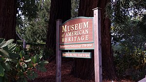
Museum of American Heritage
Palo Alto museum for 1750s-1950s electrical and mechanical technology and inventions
Distance: Approx. 338 meters
Latitude and longitude: 37.444411,-122.157543
The Museum of American Heritage (MOAH) is a museum in Palo Alto, California. It is dedicated to the preservation and display of electrical and mechanical technology and inventions from the 1750s through the 1950s. The museum has a large collection of artifacts that are generally not accessible to the public.

Varsity Theatre (Palo Alto)
Distance: Approx. 248 meters
Latitude and longitude: 37.447478,-122.159306
The Varsity Theatre is a former movie palace on University Avenue in Palo Alto, California. It was designed in a mixed Mission Revival and Spanish Renaissance style by brothers James Reid and Merritt Reid and opened in 1927. The theater closed in 1994 and the building has been adapted for other commercial uses, initially as a Borders bookstore and since 2015 housing a co-working space and a Blue Bottle cafe.

Fraternal Hall Building
United States historic place
Distance: Approx. 285 meters
Latitude and longitude: 37.44333333,-122.16222222
The Fraternal Hall Building is a historic building in Palo Alto, California. It was built in 1898 for the Fraternal Hall Association. The founding members included Knights of Pythias and Freemasons.

Pacific Art League
Distance: Approx. 218 meters
Latitude and longitude: 37.44388889,-122.16005556
The Pacific Art League (PAL), formally known as the Palo Alto Art Club was founded in 1921 in Palo Alto, California and is a membership-run nonprofit arts organization, school, and gallery. The group is located in a historic building at 668 Ramona Street in downtown Palo Alto.

Palo Alto Medical Clinic
United States historic place
Distance: Approx. 407 meters
Latitude and longitude: 37.44361111,-122.15722222
Palo Alto Medical Clinic, also known as the Roth Building (structure built in 1932) was a former medical clinic. The building is located at 300 Homer street, at the corner of Bryant street in Palo Alto, California. It is listed on the National Register of Historic Places listings in Santa Clara County, California since 2010.
Maum (restaurant)
Defunct Korean restaurant in Palo Alto, California, U.S.
Distance: Approx. 53 meters
Latitude and longitude: 37.44616667,-122.16111111
Maum was a Korean restaurant in Palo Alto, California. The fine dining establishment had received a Michelin star before closing.
Weather in this IP's area
clear sky
17 Celsius
16 Celsius
14 Celsius
20 Celsius
1019 hPa
35 %
1019 hPa
1017 hPa
10000 meters
0.45 m/s
1.34 m/s
276 degree
07:20:54
18:25:46