139.104.112.87 - IP Lookup: Free IP Address Lookup, Postal Code Lookup, IP Location Lookup, IP ASN, Public IP
Country:
Region:
City:
Location:
Time Zone:
Postal Code:
IP information under different IP Channel
ip-api
Country
Region
City
ASN
Time Zone
ISP
Blacklist
Proxy
Latitude
Longitude
Postal
Route
Luminati
Country
ASN
Time Zone
America/Chicago
ISP
DSS-MT
Latitude
Longitude
Postal
IPinfo
Country
Region
City
ASN
Time Zone
ISP
Blacklist
Proxy
Latitude
Longitude
Postal
Route
IP2Location
139.104.112.87Country
Region
new york
City
new york city
Time Zone
America/New_York
ISP
Language
User-Agent
Latitude
Longitude
Postal
db-ip
Country
Region
City
ASN
Time Zone
ISP
Blacklist
Proxy
Latitude
Longitude
Postal
Route
ipdata
Country
Region
City
ASN
Time Zone
ISP
Blacklist
Proxy
Latitude
Longitude
Postal
Route
Popular places and events near this IP address

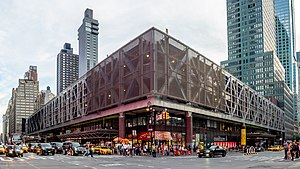
Port Authority Bus Terminal
Bus station in Manhattan, New York
Distance: Approx. 150 meters
Latitude and longitude: 40.75666667,-73.99111111
The Port Authority Bus Terminal (colloquially known as the Port Authority and by its acronym PABT) is a bus terminal located in Manhattan in New York City. It is the busiest bus terminal in the world by volume of traffic, serving about 8,000 buses and 225,000 people on an average weekday and more than 65 million people a year. The terminal is located in Midtown Manhattan at 625 Eighth Avenue between 40th Street and 42nd Street, one block east of the Lincoln Tunnel and one block west of Times Square.

Birdland (New York jazz club)
Jazz club (1949–1965, 1985–present)
Distance: Approx. 124 meters
Latitude and longitude: 40.75888889,-73.98972222
Birdland is a jazz club started in New York City on December 15, 1949. The original Birdland, which was located at 1678 Broadway, just north of West 52nd Street in Manhattan, was closed in 1965 due to increased rents, but it re-opened for one night in 1979. A revival began in 1986 with the opening of the second nightclub by the same name that is now located in Manhattan's Theater District, not far from the original nightclub's location.

330 West 42nd Street
Skyscraper in Manhattan, New York
Distance: Approx. 116 meters
Latitude and longitude: 40.7575,-73.99166667
330 West 42nd Street, also known as the McGraw-Hill Building and formerly the GHI Building, is a 485-foot-tall (148 m), 33-story skyscraper in the Hell's Kitchen neighborhood of Manhattan in New York City, New York. Designed by Raymond Hood and J. André Fouilhoux in a mixture of the International Style, Art Deco, and Art Moderne styles, the building was constructed from 1930 to 1931 and originally served as the headquarters of the McGraw-Hill Companies. The building's massing, or shape, consists of numerous setbacks facing 41st and 42nd Streets, which were included to comply with the 1916 Zoning Resolution.

Holy Cross Church (Manhattan)
Church in New York City, US
Distance: Approx. 62 meters
Latitude and longitude: 40.75805556,-73.99111111
Holy Cross Church is a Roman Catholic church located at 329 West 42nd Street between Eighth and Ninth Avenues in the Hell's Kitchen neighborhood of Manhattan, New York City, near Times Square and across the street from the Port Authority Bus Terminal.
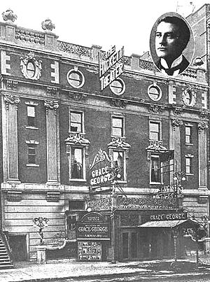
American Music Hall
Former theatre in Manhattan, New York
Distance: Approx. 140 meters
Latitude and longitude: 40.7568,-73.9896
The American Music Hall, also known as the American Theater until 1908, was one of the oldest Broadway venues. Located at 260 West 42nd Street, it was designed by the architect Charles C. Haight, with a capacity of 2,065. It opened on May 22, 1888.

Times Square Hotel
United States historic place
Distance: Approx. 128 meters
Latitude and longitude: 40.75777778,-73.98888889
The Times Square Hotel is located in New York, New York. The building was built in 1922 and was added to the National Register of Historic Places on May 4, 1995.

Eleven Times Square
Commercial skyscraper in Manhattan, New York
Distance: Approx. 158 meters
Latitude and longitude: 40.756596,-73.989672
Eleven Times Square is an office and retail tower located at 640 Eighth Avenue, at the intersection with West 42nd Street, in the Times Square and West Midtown neighborhoods of Manhattan, New York City. The 40-story, 1,100,000-square-foot (102,193 m2) tower rises 601 feet (183 m), making it the 131st tallest building in New York City. The structure is directly east of the Port Authority Bus Terminal and immediately north of The New York Times Building.
Terminal Bar (bar)
Distance: Approx. 180 meters
Latitude and longitude: 40.7563,-73.990108
Terminal Bar was a bar on Times Square in New York City at 41st Street and 8th Avenue. It had a reputation as one of the roughest bars in the city and was located across from the Port Authority Bus Terminal. Terminal Bar originally had a mainly Irish American clientele, but over time evolved into a predominantly African American and gay bar.

Empire Theatre (42nd Street)
Movie theater in Manhattan, New York
Distance: Approx. 172 meters
Latitude and longitude: 40.75666667,-73.98916667
The Empire Theatre (originally the Eltinge Theatre) is a former Broadway theater at 234 West 42nd Street in the Theater District of Midtown Manhattan in New York City. Opened in 1912, the theater was designed by Thomas W. Lamb for the Hungarian-born impresario A. H. Woods. It was originally named for female impersonator Julian Eltinge, a performer with whom Woods was associated.
True Colors United
Distance: Approx. 72 meters
Latitude and longitude: 40.75847222,-73.99
True Colors United (formerly True Colors Fund) is an American nonprofit organization addressing the issue of youth homelessness in the United States. Founded in 2008 by Cyndi Lauper, the organization focuses on the unique experiences of LGBT youth, who make up 40% of the homeless youth population in the United States.

Anco Cinema
Former Broadway theater and cinema
Distance: Approx. 162 meters
Latitude and longitude: 40.75674,-73.98924
The Anco Cinema was a former Broadway theatre turned cinema at 254 West 42nd Street, between 7th and 8th Avenues in Manhattan, New York City. It opened in 1904 and was originally named the Lew Fields Theatre. It continued to operate as a playhouse under various names until it was converted into a movie theatre in 1930.

2017 New York City Subway bombing
Terrorist attack on the New York City Subway
Distance: Approx. 180 meters
Latitude and longitude: 40.75634,-73.98983
On December 11, 2017, a pipe bomb partially detonated in a corridor between the Times Square–42nd Street and 42nd Street–Port Authority Bus Terminal subway stations adjoining the Port Authority Bus Terminal in Midtown Manhattan, New York City, injuring four people including the bomber. Mayor Bill de Blasio described the incident as "an attempted terrorist attack". The bomber was identified by police as 27-year-old Akayed Ullah, a Salafi Muslim immigrant from Bangladesh; he was convicted in 2018 and sentenced to life in prison in 2021.
Weather in this IP's area
clear sky
5 Celsius
1 Celsius
4 Celsius
6 Celsius
1016 hPa
51 %
1016 hPa
1014 hPa
10000 meters
4.92 m/s
5.36 m/s
51 degree