138.7.193.243 - IP Lookup: Free IP Address Lookup, Postal Code Lookup, IP Location Lookup, IP ASN, Public IP
Country:
Region:
City:
Location:
Time Zone:
Postal Code:
IP information under different IP Channel
ip-api
Country
Region
City
ASN
Time Zone
ISP
Blacklist
Proxy
Latitude
Longitude
Postal
Route
Luminati
Country
Region
wa
City
perth
ASN
Time Zone
Australia/Perth
ISP
Australian Academic and Research Network AARNet
Latitude
Longitude
Postal
IPinfo
Country
Region
City
ASN
Time Zone
ISP
Blacklist
Proxy
Latitude
Longitude
Postal
Route
IP2Location
138.7.193.243Country
Region
queensland
City
townsville
Time Zone
Australia/Brisbane
ISP
Language
User-Agent
Latitude
Longitude
Postal
db-ip
Country
Region
City
ASN
Time Zone
ISP
Blacklist
Proxy
Latitude
Longitude
Postal
Route
ipdata
Country
Region
City
ASN
Time Zone
ISP
Blacklist
Proxy
Latitude
Longitude
Postal
Route
Popular places and events near this IP address

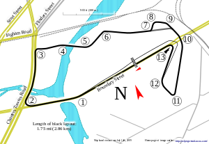
Reid Park Street Circuit
Motorsport circuit in Townsville, Australia
Distance: Approx. 711 meters
Latitude and longitude: -19.27194444,146.80916667
Reid Park Street Circuit, also known as the Townsville Street Circuit, is a semi-permanent street circuit located in Townsville, Queensland, Australia. Opened in 2009, the circuit hosts the Townsville 500 Supercars Championship event every year.
Mater Women's and Children's Hospital
Hospital in Queensland, Australia
Distance: Approx. 756 meters
Latitude and longitude: -19.27261111,146.80333333
Mater Women's and Children's Hospital in Hyde Park, Townsville, Queensland was established in 2007 when the Sisters of Mercy (Mater Health Services North Queensland) bought the competing private obstetric hospital, the Wesley/Park Haven Hospital.
Townsville railway station
Railway station in Queensland, Australia
Distance: Approx. 395 meters
Latitude and longitude: -19.2693,146.808
Townsville railway station is located on the North Coast line in Queensland, Australia. It serves the city of Townsville. The station has one platform.

West End Cemetery
Historic site in Queensland, Australia
Distance: Approx. 432 meters
Latitude and longitude: -19.266,146.8019
West End Cemetery is a heritage-listed cemetery at Francis Street, West End, City of Townsville, Queensland, Australia. It was built from 1865 to 1930s. It is also known as Townsville General Cemetery.

Saints Theodores Greek Orthodox Church
Historic site in Queensland, Australia
Distance: Approx. 199 meters
Latitude and longitude: -19.2676,146.8073
Saints Theodores Greek Orthodox Church is a heritage-listed church at 799 Flinders Street, Townsville CBD, City of Townsville, Queensland, Australia. It was designed by M. Vogiatzoglou and Joseph Gabriel Rooney, and built from 1947 to 1950 by Vause and Hayne. It was added to the Queensland Heritage Register on 25 August 2000.

St Mary's Church & Convent, Townsville
Church in Australia
Distance: Approx. 482 meters
Latitude and longitude: -19.2692,146.8026
St Mary's Church and Convent are heritage-listed Roman Catholic church buildings at 34 Ingham Road, West End, City of Townsville, Queensland, Australia. It was designed by the Rooney Brothers and built by Cowell & Holt in 1888. It was added to the Queensland Heritage Register on 2 January 1993.

Townsville Masonic Hall
Historic site in Queensland, Australia
Distance: Approx. 472 meters
Latitude and longitude: -19.2648,146.8102
Townsville Masonic Hall is a heritage-listed former masonic temple at 485-493 Sturt Street, Townsville CBD, City of Townsville, Queensland, Australia. It was designed by W G Smith & Sons and built in 1889 by Sparre & Hansen. It is also known as Assembly of God Hall, Calvary Temple, Townsville Choral & Orchestral Society Building, Townsville Choral Society Inc.

West End Hotel, Townsville
Historic site in Queensland, Australia
Distance: Approx. 803 meters
Latitude and longitude: -19.2677,146.7985
West End Hotel is a heritage-listed hotel at 89 Ingham Road, West End, City of Townsville, Queensland, Australia. It was built in 1885 by Peter Dean. It was added to the Queensland Heritage Register on 24 June 1999.
Currajong, West End
Historic site in Queensland, Australia
Distance: Approx. 619 meters
Latitude and longitude: -19.2707,146.8024
Currajong is a heritage-listed detached house at 5 Castling Street, West End, City of Townsville, Queensland, Australia. It was built from 1887 to 1888. It was added to the Queensland Heritage Register on 21 October 1992.

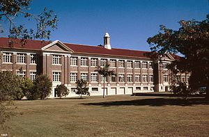
Townsville West State School
Historic site in Queensland, Australia
Distance: Approx. 306 meters
Latitude and longitude: -19.2681,146.8038
Townsville West State School is a heritage-listed former state school at 29 Ingham Road, West End, City of Townsville, Queensland, Australia. It was built from 1921 to 1939. It is also known as Townsville and District Education Centre and Memorial Gates.

Townsville Baptist Church
Historic site in Queensland, Australia
Distance: Approx. 435 meters
Latitude and longitude: -19.265,146.8099
Townsville Baptist Church is a former heritage-listed church building at 513 Sturt Street, Townsville CBD, City of Townsville, Queensland, Australia. It was built in 1922. Since 1985, it has been occupied by the Potter's House Christian Fellowship.

Lion Brewery, Townsville
Brewery in Townsville, Queensland
Distance: Approx. 341 meters
Latitude and longitude: -19.2668,146.8092
Lion Brewery is a heritage-listed former brewery at 719–741 Flinders Street, Townsville CBD, City of Townsville, Queensland, Australia. It was designed by John B Nicholson and built in 1894 by Madsen & Watson. It is also known as Eagers Showroom, Playpen, and Townsville Brewery.
Weather in this IP's area
scattered clouds
26 Celsius
27 Celsius
26 Celsius
26 Celsius
1006 hPa
89 %
1006 hPa
1004 hPa
10000 meters
0.51 m/s
130 degree
40 %
