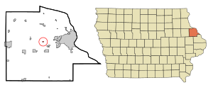
Country:
 USA
USARegion:
City:
Latitude and Longitude:
Time Zone:
Postal Code:
IP information under different IP Channel
ip-api
Country
Region
City
ASN
Time Zone
ISP
Blacklist
Proxy
Latitude
Longitude
Postal
Route
IPinfo
Country
Region
City
ASN
Time Zone
ISP
Blacklist
Proxy
Latitude
Longitude
Postal
Route
MaxMind
Country
Region
City
ASN
Time Zone
ISP
Blacklist
Proxy
Latitude
Longitude
Postal
Route
Luminati
Country
USRegion
ia
City
epworth
ASN
Time Zone
America/Chicago
ISP
MVLINK
Latitude
Longitude
Postal
db-ip
Country
Region
City
ASN
Time Zone
ISP
Blacklist
Proxy
Latitude
Longitude
Postal
Route
ipdata
Country
Region
City
ASN
Time Zone
ISP
Blacklist
Proxy
Latitude
Longitude
Postal
Route
Popular places and events near this IP address

Dubuque County, Iowa
County in Iowa, United States
Distance: Approx. 5444 meters
Latitude and longitude: 42.47083333,-90.87833333
Dubuque County is a county located in the U.S. state of Iowa. As of the 2020 census, the population was 99,266, making it the eighth-most populous county in Iowa. The county seat is Dubuque.

Centralia, Iowa
City in Iowa, United States
Distance: Approx. 8374 meters
Latitude and longitude: 42.47222222,-90.83611111
Centralia is a city in Dubuque County, Iowa, United States. It is part of the Dubuque, Iowa Metropolitan Statistical Area. The population was 116 at the 2020 census, up 15 persons since the 2000 census and down 18 from the 2010.

Epworth, Iowa
City in Iowa, United States
Distance: Approx. 1063 meters
Latitude and longitude: 42.44583333,-90.93111111
Epworth is a city in Dubuque County, Iowa, United States. It is part of the Dubuque, Iowa Metropolitan Statistical Area. The population was 2,023 at the 2020 census, up from 1,428 in 2000.

Farley, Iowa
City in Iowa, United States
Distance: Approx. 6882 meters
Latitude and longitude: 42.44388889,-91.00944444
Farley is a city in Dubuque County, Iowa, United States. It is part of the Dubuque, Iowa Metropolitan Statistical Area. The population was 1,766 at the time of the 2020 census, up from 1,334 in 2000.
Graf, Iowa
City in Iowa, United States
Distance: Approx. 7845 meters
Latitude and longitude: 42.495,-90.87194444
Graf is a city in Dubuque County, Iowa, United States. It is part of the 'Dubuque, Iowa Metropolitan Statistical Area'. The population was 76 at the time of the 2020 census, up from 73 in 2000.

Peosta, Iowa
City in Iowa, United States
Distance: Approx. 6695 meters
Latitude and longitude: 42.44916667,-90.84638889
Peosta is a city in Dubuque County, Iowa, United States, and an exurb of the city of Dubuque. It is part of the Dubuque, Iowa Metropolitan Statistical Area. The population was 1,908 in the 2020 census, an increase of 193% from 651 in 2000.

Divine Word College
Distance: Approx. 457 meters
Latitude and longitude: 42.44,-90.93
Divine Word College is a private undergraduate Roman Catholic seminary run by the Society of the Divine Word in Epworth, Iowa. It was founded by the Divine Word Missionaries in 1964. It educates students for missionary service in the Catholic Church as priests, brothers, sisters, and laypersons.
Western Dubuque Community School District
Public school district in Farley, Iowa, United States
Distance: Approx. 6938 meters
Latitude and longitude: 42.439578,-91.010584
The Western Dubuque Community School District, (WDCSD; also known as Western Dubuque or WD) is a rural public school district based in Farley, Iowa (USA). The district, which operates schools in western Dubuque County, is about 550 square miles (1,400 km2) in area, making it the largest school district (by area) in Iowa.

Western Dubuque High School
Public secondary school in Epworth, Iowa, United States
Distance: Approx. 1488 meters
Latitude and longitude: 42.442,-90.943
Western Dubuque High School (commonly West Dubuque, West Dub, WDHS, or WD) is a four-year public high school located in Epworth, Iowa. It is one of two high schools in the Western Dubuque Community School District, and enrolls 935 students in grades 9-12. The school's mascot is the Bobcat, and it competes in class 3A of the Mississippi Valley Conference.
Lincoln School (Farley, Iowa)
United States historic place
Distance: Approx. 7638 meters
Latitude and longitude: 42.49,-90.98527778
Lincoln School, also known as the W.J. McGee Boyhood School, is a historic building located north of Farley, Iowa, United States. This is a typical Iowa one-room schoolhouse that features frame construction, rectangular shape, and a gable roof. The entryway on the front was added in the 1890s.

Epworth School (Epworth, Iowa)
United States historic place
Distance: Approx. 1273 meters
Latitude and longitude: 42.44611111,-90.93555556
Epworth School, also known as the Epworth Elementary School, was a historic building located in Epworth, Iowa, United States. The Iowa Legislature required a high school education for all students in 1911. The school districts that did not have a high school were required the pay their student's tuition in a district that did.

Zephaniah Kidder House
Historic house in Iowa, United States
Distance: Approx. 1070 meters
Latitude and longitude: 42.44638889,-90.929
The Zephaniah Kidder House is a historic building located in Epworth, Iowa, United States. A Maine native, Kidder settled in Iowa in 1853 after spending time in California. He was one of three men who established the town of Epworth on their land holdings in 1855.
Weather in this IP's area
clear sky
9 Celsius
7 Celsius
8 Celsius
10 Celsius
1030 hPa
71 %
1030 hPa
994 hPa
10000 meters
3.6 m/s
210 degree
07:21:44
18:15:04