138.219.159.215 - IP Lookup: Free IP Address Lookup, Postal Code Lookup, IP Location Lookup, IP ASN, Public IP
Country:
Region:
City:
Location:
Time Zone:
Postal Code:
ISP:
ASN:
language:
User-Agent:
Proxy IP:
Blacklist:
IP information under different IP Channel
ip-api
Country
Region
City
ASN
Time Zone
ISP
Blacklist
Proxy
Latitude
Longitude
Postal
Route
db-ip
Country
Region
City
ASN
Time Zone
ISP
Blacklist
Proxy
Latitude
Longitude
Postal
Route
IPinfo
Country
Region
City
ASN
Time Zone
ISP
Blacklist
Proxy
Latitude
Longitude
Postal
Route
IP2Location
138.219.159.215Country
Region
chalatenango
City
chalatenango
Time Zone
America/El_Salvador
ISP
Language
User-Agent
Latitude
Longitude
Postal
ipdata
Country
Region
City
ASN
Time Zone
ISP
Blacklist
Proxy
Latitude
Longitude
Postal
Route
Popular places and events near this IP address

San Antonio Los Ranchos
Municipality in Chalatenango, El Salvador
Distance: Approx. 5165 meters
Latitude and longitude: 14,-88.9
San Antonio Los Ranchos is a municipality in the Chalatenango department of El Salvador.

San Miguel de Mercedes
Municipality in Chalatenango Department, El Salvador
Distance: Approx. 1852 meters
Latitude and longitude: 14.01666667,-88.93333333
San Miguel de Mercedes is a municipality in the Chalatenango department of El Salvador.

Chalatenango, Chalatenango
Capital of the Salvadoran department of Chalatenango
Distance: Approx. 5 meters
Latitude and longitude: 14.03333333,-88.93333333
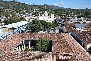
Chalatenango (Spanish pronunciation: [tʃalateˈnaŋɡo]; known as "Chalate" [tʃaˈlate] by locals) is a town and district in the Chalatenango department of El Salvador. It is the capital of the department. As of 1 May 2021, Alfredo Hernández of Nuevas Ideas (NI) is the municipality's mayor.
Las Vueltas
Municipality in Chalatenango, El Salvador
Distance: Approx. 8216 meters
Latitude and longitude: 14.09361111,-88.88944444
Las Vueltas is a municipality in the Chalatenango Department in the north of El Salvador. The municipality is bordered to the north by Ojos de Agua, to the east by Las Flores, to the south by Chalatenango, and to the northeast by Concepción Quezaltepeque. The territory covers 36.83 km2 and the population was, as of 2005, of 2,101 inhabitants.
A.D. Chalatenango
Soccer club
Distance: Approx. 3899 meters
Latitude and longitude: 14.04277778,-88.96805556
Asociación Deportiva Chalatenango is a Salvadoran professional football club based in Chalatenango, El Salvador, they are currently playing in the top-tier Primera División de Fútbol de El Salvador. The club was founded in 1950 as C.D. Alacranes, and reformed in 1975, as C.D. Chalatenango. In 1975, the club relocated to their current stadium, the Estadio José Gregorio Martínez stadium.

Estadio José Gregorio Martínez
Stadium in Chalatenango, El Salvador
Distance: Approx. 3884 meters
Latitude and longitude: 14.042713,-88.967929
The Estadio José Gregorio Martínez is a multi-use stadium located in the city of Chalatenango, El Salvador. Specifically in the Km 72 ½ mile of the road leading from San Salvador to the provincial capital, is used for football, where the local team Chalatenango plays.

Roman Catholic Diocese of Chalatenango
Roman Catholic diocese in El Salvador
Distance: Approx. 1107 meters
Latitude and longitude: 14.0415,-88.9391
The Diocese of Chalatenango is a Latin Church ecclesiastical territory or diocese of the Catholic Church in El Salvador. It is a suffragan diocese in the ecclesiastical province of the metropolitan Archdiocese of San Salvador. The Diocese of Chalatenango was erected on 30 December 1987.

Chalatenango, El Salvador
Municipality in Chalatenango Department, El Salvador
Distance: Approx. 1039 meters
Latitude and longitude: 14.04,-88.94
Chalatenango is a municipality located in the Department of Chalatenango, in the north of El Salvador.
Concepción Quetzaltepeque, El Salvador
Municipality in Chalatenango Department, El Salvador
Distance: Approx. 5854 meters
Latitude and longitude: 14.08333333,-88.95
Concepción Quetzaltepeque is a municipality in the department of Chalatenango in the north of El Salvador. It is bordered to the north by Comalapa and La Laguna, to the east by Las Vueltas and Chalatenango, to the south by Chalatenango, and to the west by Santa Rita. The territorial extension of the municipality is 52.54 km2.
La Laguna, El Salvador
Municipality in Chalatenango Department, El Salvador
Distance: Approx. 8098 meters
Latitude and longitude: 14.06666667,-88.86666667
La Laguna is a municipality in the Chalatenango department of El Salvador.

St. John the Baptist Cathedral (El Salvador)
Roman Catholic cathedral in El Salvador
Distance: Approx. 1101 meters
Latitude and longitude: 14.04138889,-88.93916667
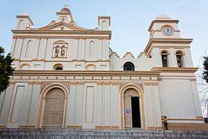
St. John the Baptist Cathedral (Spanish: Catedral San Juan Bautista), also known as the Chalatenango Cathedral (Catedral de Chalatenango), is a Roman Catholic cathedral located in Chalatenango, El Salvador.

Chalatenango Sur
Municipality in Chalatenango, El Salvador
Distance: Approx. 1122 meters
Latitude and longitude: 14.041,-88.94
Chalatenango Sur (Southern Chalatenango) is one of the 44 municipalities of El Salvador. This municipality is made up of 20 districts Arcatao, Azacualpa, San José Cancasque, Chalatenango, Compalapa, Concepción Quezaltepeque El Carrizal, La Laguna, Las Vueltas, Las Flores, Nombre de Jesús, Nueva Trinidad, Ojos de Agua, Potonico, San Antonio de la Cruz, San Antonio Los Ranchos, San Francisco Lempa, San Isidro Labrador, San Luis del Carmen and San Miguel de Mercedes. The municipality comprises the largest amount of districts within the entire country.
Weather in this IP's area
clear sky
16 Celsius
16 Celsius
16 Celsius
16 Celsius
1017 hPa
93 %
1017 hPa
965 hPa
10000 meters
0.97 m/s
1.27 m/s
306 degree
1 %