138.219.156.79 - IP Lookup: Free IP Address Lookup, Postal Code Lookup, IP Location Lookup, IP ASN, Public IP
Country:
Region:
City:
Location:
Time Zone:
Postal Code:
IP information under different IP Channel
ip-api
Country
Region
City
ASN
Time Zone
ISP
Blacklist
Proxy
Latitude
Longitude
Postal
Route
Luminati
Country
Region
li
City
nuevocuscatlan
ASN
Time Zone
America/El_Salvador
ISP
Navega.com S.A.
Latitude
Longitude
Postal
IPinfo
Country
Region
City
ASN
Time Zone
ISP
Blacklist
Proxy
Latitude
Longitude
Postal
Route
IP2Location
138.219.156.79Country
Region
la libertad
City
ciudad arce
Time Zone
America/El_Salvador
ISP
Language
User-Agent
Latitude
Longitude
Postal
db-ip
Country
Region
City
ASN
Time Zone
ISP
Blacklist
Proxy
Latitude
Longitude
Postal
Route
ipdata
Country
Region
City
ASN
Time Zone
ISP
Blacklist
Proxy
Latitude
Longitude
Postal
Route
Popular places and events near this IP address
Joya de Cerén
Distance: Approx. 9948 meters
Latitude and longitude: 13.8275,-89.35611111
Joya de Cerén (Jewel of Cerén in the Spanish language) is an archaeological site in La Libertad Department, El Salvador, featuring a pre-Columbian Maya farming village. The ancient Maya site of Joya de Cerén is located in the Zapotitán Valley, 36 kilometers northwest of San Salvador, El Salvador. It is often referred to as the "Pompeii of the Americas", in comparison to the famed Ancient Roman ruins.

Ciudad Arce
Municipality in La Libertad, El Salvador
Distance: Approx. 1688 meters
Latitude and longitude: 13.83333333,-89.43333333
Ciudad Arce is a municipality in the La Libertad department of El Salvador. It is approximately 25 kilometres (16 mi) northwest of the national capital, San Salvador. It is named after Manuel José Arce.

El Congo
Municipality in Santa Ana, El Salvador
Distance: Approx. 7708 meters
Latitude and longitude: 13.9,-89.48333333
El Congo is a city and municipality in the Santa Ana department of El Salvador.

San Andrés, El Salvador
Distance: Approx. 7652 meters
Latitude and longitude: 13.80055556,-89.38944444
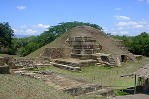
San Andrés (formerly known as Campana San Andrés) is a pre-Columbian site in El Salvador, whose occupation began around the year 900 BC as an agricultural town in the valley of Zapotitán in the department of La Libertad. This early establishment was vacated by the year 250 because of the enormous eruption of the caldera of Lago Ilopango, and was occupied again in the 5th Century, along with many other sites in the valley of Zapotitán. Between 600 and 900 AD, San Andrés was the capital of a Maya polity with supremacy over the other establishments of Valle de Zapotitán.
San José Las Flores, Santa Ana
Distance: Approx. 6388 meters
Latitude and longitude: 13.86861111,-89.49861111
San José Las Flores is a settlement in Santa Ana Department, El Salvador.
Weather in this IP's area
few clouds
23 Celsius
23 Celsius
23 Celsius
23 Celsius
1015 hPa
77 %
1015 hPa
932 hPa
10000 meters
1.3 m/s
1.8 m/s
20 degree
22 %
