138.186.31.9 - IP Lookup: Free IP Address Lookup, Postal Code Lookup, IP Location Lookup, IP ASN, Public IP
Country:
Region:
City:
Location:
Time Zone:
Postal Code:
ISP:
ASN:
language:
User-Agent:
Proxy IP:
Blacklist:
IP information under different IP Channel
ip-api
Country
Region
City
ASN
Time Zone
ISP
Blacklist
Proxy
Latitude
Longitude
Postal
Route
db-ip
Country
Region
City
ASN
Time Zone
ISP
Blacklist
Proxy
Latitude
Longitude
Postal
Route
IPinfo
Country
Region
City
ASN
Time Zone
ISP
Blacklist
Proxy
Latitude
Longitude
Postal
Route
IP2Location
138.186.31.9Country
Region
hidalgo
City
tulancingo
Time Zone
America/Mexico_City
ISP
Language
User-Agent
Latitude
Longitude
Postal
ipdata
Country
Region
City
ASN
Time Zone
ISP
Blacklist
Proxy
Latitude
Longitude
Postal
Route
Popular places and events near this IP address

Roman Catholic Archdiocese of Tulancingo
Latin Catholic archdiocese in Mexico
Distance: Approx. 410 meters
Latitude and longitude: 20.080425,-98.36915278
The Archdiocese of Tulancingo (Latin: Archidioecesis Tulancingensis) is an archdiocese of the Latin Church of the Catholic Church in Mexico. The Archdiocese comprises the province of Hidalgo, and the archiepiscopal see is located in the Mexican city of Tulancingo As a Metropolitan Archdiocese, it is responsible for the suffragan dioceses of Huejutla and Tula. It was elevated as an archdiocese on November 25, 2005.

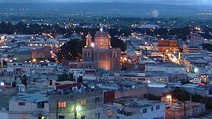
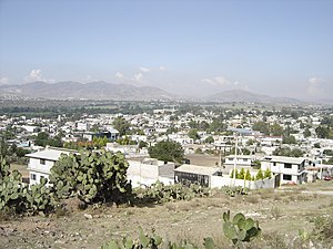
Tulancingo
Municipality and city in Hidalgo, Mexico
Distance: Approx. 5 meters
Latitude and longitude: 20.08333333,-98.36666667
Tulancingo (officially Tulancingo de Bravo; Otomi: Ngu̱hmu) is the second-largest city in the Mexican state of Hidalgo. It is located in the southeastern part of the state and also forms one of the 84 municipalities of Hidalgo, as well as the Archdiocese of Tulancingo. Located 93 km from Mexico City, this area is the most important wool textile producer in the country and was home to El Santo, Mexico's most famous lucha libre wrestler, and to Gabriel Vargas (cartoonist), author of the popular cartoon La Familia Burrón.
Tulantepec de Lugo Guerrero
Municipality in Hidalgo, Mexico
Distance: Approx. 5133 meters
Latitude and longitude: 20.03833333,-98.35583333
Tulantepec de Lugo Guerrero is one of the 84 municipalities of Hidalgo, in central-eastern Mexico. The municipality covers an area of 89.9 km2. As of 2020, the municipality had a total population of 39,561, with 47.1% men and 52.9% women.

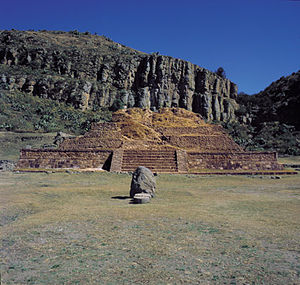
Huapalcalco
Pre-Columbian Mesoamerican archeological site
Distance: Approx. 3781 meters
Latitude and longitude: 20.11702,-98.3624
Huapalcalco is a pre-Columbian Mesoamerican archeological site located some 5 kilometres (3.1 mi) north of Tulancingo in the state of Hidalgo, Mexico. The site was built on the west slope of the "Tecolote" hill; the slope is separated east-west by a ravine that forms two sectors at the foot of the hill and two more on the top, all of which contain archaeological vestiges. The site depicts Teotihuacan influence, and some believe that Topilitzin Quetzalcóatl resided here, before governing Tula.

Tulancingo Cathedral
Church in Tulancingo, Mexico
Distance: Approx. 322 meters
Latitude and longitude: 20.0806,-98.3678
The St. John the Baptist Cathedral (Spanish: Catedral de San Juan Bautista) Also Tulancingo Cathedral It is a Catholic religious building that constitutes a work of the architecture of colonial Mexico built from 1528 by the Franciscan Order. Its combination of imposing and yet simple elements stand out in the historical center of Tulancingo, in the state of Hidalgo, in front of the main square La Floresta.
Santiago Tulantepec
Town in Hidalgo, Mexico
Distance: Approx. 4946 meters
Latitude and longitude: 20.03972222,-98.3575
Santiago Tulantepec is a town in Mexico that is the municipal seat of Tulantepec de Lugo Guerrero, in the state of Hidalgo..

4th federal electoral district of Hidalgo
Federal electoral district of Mexico
Distance: Approx. 5 meters
Latitude and longitude: 20.08333333,-98.36666667
The 4th federal electoral district of Hidalgo (Distrito electoral federal 04 de Hidalgo) is one of the 300 electoral districts into which Mexico is divided for elections to the federal Chamber of Deputies and one of the seven currently operational districts in the state of Hidalgo. It elects one deputy to the lower house of Congress for each three-year legislative period by means of the first-past-the-post system. As of 2024, votes cast in the district also count towards the calculation of proportional representation ("plurinominal") deputies elected from the fourth electoral region.
Weather in this IP's area
few clouds
11 Celsius
11 Celsius
11 Celsius
11 Celsius
1023 hPa
84 %
1023 hPa
763 hPa
10000 meters
0.24 m/s
0.64 m/s
123 degree
22 %
