Country:
 Mexico
Region:
City:
Latitude and Longitude:
Time Zone:
Postal Code:
IP information under different IP Channel
ip-api
Country
Region
City
ASN
Time Zone
ISP
Blacklist
Proxy
Latitude
Longitude
Postal
Route
IPinfo
Country
Region
City
ASN
Time Zone
ISP
Blacklist
Proxy
Latitude
Longitude
Postal
Route
MaxMind
Country
Region
City
ASN
Time Zone
ISP
Blacklist
Proxy
Latitude
Longitude
Postal
Route
Luminati
Country
MXRegion
coa
City
piedrasnegras
ASN
Time Zone
America/Matamoros
ISP
Spectro Networks Telecomunicaciones, S. de R.L. de C.V.
Latitude
Longitude
Postal
db-ip
Country
Region
City
ASN
Time Zone
ISP
Blacklist
Proxy
Latitude
Longitude
Postal
Route
ipdata
Country
Region
City
ASN
Time Zone
ISP
Blacklist
Proxy
Latitude
Longitude
Postal
Route
Popular places and events near this IP address

Piedras Negras, Coahuila
City in the Mexican state of Coahuila
Distance: Approx. 2166 meters
Latitude and longitude: 28.7,-100.52305556
Piedras Negras (Spanish pronunciation: [ˈpjeðɾas ˈneɣɾas] ) is a city and seat of the surrounding municipality of the same name in the Mexican state of Coahuila. It stands at the northeastern edge of Coahuila on the Mexico–United States border, across the Rio Grande from Eagle Pass in the U.S. state of Texas. In the 2015 census the city had a population of 163,595 inhabitants, while the metropolitan area had a population of 245,155 inhabitants.

Fort Duncan
United States historic place
Distance: Approx. 3708 meters
Latitude and longitude: 28.70194444,-100.50472222
Fort Duncan was a United States Army base, set up to protect the first U.S. settlement on the Rio Grande near the current town of Eagle Pass, Texas.
KINL
Radio station in Eagle Pass, Texas
Distance: Approx. 5294 meters
Latitude and longitude: 28.733,-100.493
KINL is a radio station based in Eagle Pass, Texas. The station broadcasts at 92.7 MHz with an ERP of 20,000 watts.

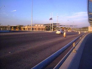
Eagle Pass–Piedras Negras International Bridge
Bridge between U.S and Mexico
Distance: Approx. 2925 meters
Latitude and longitude: 28.70555556,-100.51194444
The Eagle Pass–Piedras Negras International Bridge is an international bridge that crosses the Rio Grande and connects the United States-Mexico border cities of Eagle Pass, Texas, and Piedras Negras, Coahuila. The bridge is also known as "Eagle Pass Bridge 1" and "Puente Piedras Negras-Eagle Pass". The road continues into Eagle Pass as U.S. Route 57, and into Piedras Negras as Mexican Federal Highway 57.

Camino Real International Bridge
Bridge
Distance: Approx. 3344 meters
Latitude and longitude: 28.69777778,-100.51055556
The Camino Real International Bridge is an international bridge which crosses the Rio Grande connecting the United States-Mexico border cities of Eagle Pass, Texas, and Piedras Negras, Coahuila. The bridge is also known as "Eagle Pass-Piedras Negras International Bridge II", "Puente Dos", "Puente Camino Real" and "Puente Internacional Coahuila 2000".
Union Pacific International Railroad Bridge
Distance: Approx. 3440 meters
Latitude and longitude: 28.69638889,-100.51027778
The Union Pacific International Railroad Bridge is the only railway international bridge that crosses the U.S.-Mexico border between the cities of Eagle Pass, Texas, and Piedras Negras, Coahuila. The U.S. portion is owned and operated by Union Pacific Railroad, with BNSF Railway having trackage rights. The Mexican portion is owned by the Mexican federal government, with operation concessioned to Ferromex.
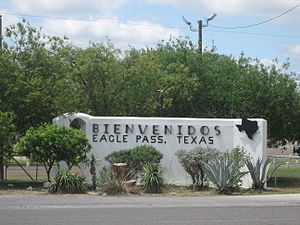
Eagle Pass, Texas
City in Texas, United States
Distance: Approx. 5054 meters
Latitude and longitude: 28.71055556,-100.48944444
Eagle Pass is a city in and the county seat of Maverick County in the U.S. state of Texas. Its population was 28,130 as of the 2020 census. Eagle Pass borders the city of Piedras Negras, Coahuila, Mexico, which is to the southwest and across the Rio Grande.
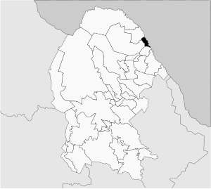
Piedras Negras Municipality
Municipality in the Mexican state of Coahuila
Distance: Approx. 2895 meters
Latitude and longitude: 28.72222222,-100.56805556
Piedras Negras Municipality is one of the 38 municipalities of Coahuila, in north-eastern Mexico. The municipal seat lies at Piedras Negras. The municipality covers an area of 914.2 km2 and is located on the international border between Mexico and the USA, here formed by the Río Bravo del Norte (Rio Grande), adjacent to the U.S. state of Texas.

Eagle Pass Port of Entry
Border crossing between Mexico and the US
Distance: Approx. 3432 meters
Latitude and longitude: 28.705779,-100.506594
The Eagle Pass Port of Entry on the United States–Mexico border was established around 1896. The first carriage bridge connecting Eagle Pass, Texas, with Piedras Negras, Coahuila (then known as Ciudad Porfirio Díaz) was built in April 1890, but was destroyed in a flood in September 1890. The bridge was soon replaced by the Eagle Pass–Piedras Negras International Bridge, and was again rebuilt in 1927 and 1954.
Eagle Pass Camino Real Port of Entry
Distance: Approx. 3687 meters
Latitude and longitude: 28.698328,-100.506411
The Eagle Pass Camino Real Port of Entry (sometimes called "Eagle Pass II") is located on the United States–Mexico border at the Camino Real International Bridge. Built in 1999, it is the location where all commercial vehicles entering Eagle Pass, Texas, from Piedras Negras, Coahuila, are inspected.
Elm Creek (Rio Grande tributary)
Distance: Approx. 4704 meters
Latitude and longitude: 28.74361111,-100.51027778
See Elm Creek (Nueces River tributary) for the tributary of the Nueces River, in Maverick County, Texas. Elm Creek, is one of two streams of that name in Kinney County and Maverick County, Texas. Elm Creek joins the Rio Grande about 4 miles downstream from Elm Creek, Texas, and 1.1 miles up river from Eagle Pass, Texas.
Seco Mines, Texas
CDP in Texas, United States
Distance: Approx. 5896 meters
Latitude and longitude: 28.7475,-100.49722222
Seco Mines is an unincorporated community and census-designated place in Maverick County, Texas, United States. Its population was 572 as of the 2020 census. U.S. Route 277 passes through the community.
Weather in this IP's area
scattered clouds
30 Celsius
34 Celsius
29 Celsius
32 Celsius
1009 hPa
60 %
1009 hPa
984 hPa
10000 meters
3.09 m/s
120 degree
40 %
07:27:56
19:45:54