Country:
 Mexico
Region:
City:
Latitude and Longitude:
Time Zone:
Postal Code:
IP information under different IP Channel
ip-api
Country
Region
City
ASN
Time Zone
ISP
Blacklist
Proxy
Latitude
Longitude
Postal
Route
IPinfo
Country
Region
City
ASN
Time Zone
ISP
Blacklist
Proxy
Latitude
Longitude
Postal
Route
MaxMind
Country
Region
City
ASN
Time Zone
ISP
Blacklist
Proxy
Latitude
Longitude
Postal
Route
Luminati
Country
MXRegion
coa
City
saltillo
ASN
Time Zone
America/Monterrey
ISP
Spectro Networks Telecomunicaciones, S. de R.L. de C.V.
Latitude
Longitude
Postal
db-ip
Country
Region
City
ASN
Time Zone
ISP
Blacklist
Proxy
Latitude
Longitude
Postal
Route
ipdata
Country
Region
City
ASN
Time Zone
ISP
Blacklist
Proxy
Latitude
Longitude
Postal
Route
Popular places and events near this IP address

Universidad Autónoma Agraria Antonio Narro
Mexican University
Distance: Approx. 3630 meters
Latitude and longitude: 25.3934,-101.0005
The Antonio Narro Agrarian Autonomous University or Universidad Autónoma Agraria Antonio Narro in Spanish (UAAAN) is a public university in Mexico dedicated to the Agricultural, Silvicultural, Animal Production, food and Environmental Sciences. It is located 6 km (3.7 mi) south of Saltillo, in the Mexican state of Coahuila. The Antonio Narro Agrarian Autonomous University is one of the most important agricultural colleges of Latin America, and the "Narro" has national and international recognition in the agricultural and animal industry and the high academic level.
Saltillo Institute of Technology
Distance: Approx. 2493 meters
Latitude and longitude: 25.4433,-100.9939
The Saltillo Institute of Technology (Spanish: Instituto Tecnológico de Saltillo), or ITS, is located in the city of Saltillo, state capital of Coahuila, Mexico. It is a college level technological institution. Founded in July 1950 by Mexican President Miguel Alemán Valdez, it started operations on January 3, 1951.

Estadio de Béisbol Francisco I. Madero
Distance: Approx. 3130 meters
Latitude and longitude: 25.43365278,-100.97880556
Estadio Francisco I. Madero is a stadium in Saltillo, Mexico. It is primarily used for baseball and is the home field of the Saraperos de Saltillo. It holds 11,000 people, and features a video screen measuring 14 meters high by 22 meters wide (46 feet high by 72 feet wide).

San Esteban de Nueva Tlaxcala
Distance: Approx. 744 meters
Latitude and longitude: 25.422,-101.002
San Esteban de Nueva Tlaxcala was a Tlaxcalan municipality in what is now the Mexican state of Coahuila. San Esteban was the northernmost of the six Tlaxcalan colonies established in 1591 at the behest of the Viceroy of New Spain, Luis de Velasco; its founders came from Tizatlan. In 1834, San Esteban was merged into the adjoining city of Saltillo.
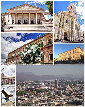
Saltillo
City in Coahuila, Mexico
Distance: Approx. 1682 meters
Latitude and longitude: 25.42305556,-100.99194444
Saltillo (Latin American Spanish: [salˈtiʝo] ) is the capital and largest city of the northeastern Mexican state of Coahuila and is also the municipal seat of the municipality of the same name. Mexico City, Monterrey, and Saltillo are all connected by a major railroad and highway. As of a 2020 census, Saltillo had a population of 879,958 people, while the population of its metropolitan area was 1,031,779, making Saltillo the largest city in the state of Coahuila, and the 14th most populated metropolitan area in the country.
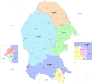
Fourth federal electoral district of Coahuila
Federal electoral district of Mexico
Distance: Approx. 2703 meters
Latitude and longitude: 25.41666667,-100.98333333
The fourth federal electoral district of Coahuila (Distrito electoral federal 04 de Coahuila) is one of the 300 electoral districts into which Mexico is divided for elections to the federal Chamber of Deputies and one of eight such districts in Coahuila. It elects one deputy to the lower house of Congress for each three-year legislative session using the first-past-the-post system. Votes cast in the district also count towards the calculation of proportional representation ("plurinominal") deputies elected from the second region.
Seventh federal electoral district of Coahuila
Federal electoral district of Mexico
Distance: Approx. 2703 meters
Latitude and longitude: 25.41666667,-100.98333333
The seventh federal electoral district of Coahuila (Distrito electoral federal 07 de Coahuila) is one of the 300 electoral districts into which Mexico is divided for elections to the federal Chamber of Deputies and one of eight such districts in the state of Coahuila. It elects one deputy to the lower house of Congress for each three-year legislative session by means of the first-past-the-post system. Votes cast in the district also count towards the calculation of proportional representation ("plurinominal") deputies elected from the second region.

Candelaria Cave
Archeological site in Mexico
Distance: Approx. 4786 meters
Latitude and longitude: 25.42111111,-100.96111111
Cueva de la Candelaria (Candelaria Cave) is an archaeological site located the Mexican state of Coahuila. It is a cave that was used as cemetery by nomad visitors. Early site research was made in 1953 and there was a later season in 1954.

Desert Museum (Mexico)
Museum in Saltillo, Coahuila, Mexico
Distance: Approx. 4668 meters
Latitude and longitude: 25.414037,-100.963744
The Desert Museum (Spanish: Museo del Desierto) is a museum in Saltillo, Coahuila, Mexico, that promotes an ecological culture. It was designed by the architect Francisco López Guerra and was inaugurated on 25 November 1999. It has a large collection of fossils and plants and includes autochthonous animals of the Mexican desert.

Estadio Olímpico de Saltillo
Multi-use stadium in Coahulia, Mexico
Distance: Approx. 2989 meters
Latitude and longitude: 25.43194444,-100.97972222
The Estadio Olímpico de Saltillo is a multi-use stadium in Saltillo, Coahuila, Mexico. It is currently used mostly for football matches and is the home stadium for Saltillo F.C. The stadium has a capacity of 7,000 people for football matches and 8,000 for American football games, due to the addition of temporary stands in both ends of the field. There are plans from Atlético Saltillo to upgrade the stadium so that it fulfills Serie A requirements.
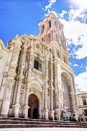
Saltillo Cathedral
Church in Saltillo, Mexico
Distance: Approx. 939 meters
Latitude and longitude: 25.4217,-101
The St. James Cathedral (Spanish: Catedral de Santiago) Also Saltillo Cathedral Is the catholic cathedral of the city of Saltillo in Mexico. It is located in the historical center of the city, opposite the Plaza de Armas, is one of the architectural jewels of the state of Coahuila.
Weather in this IP's area
scattered clouds
25 Celsius
25 Celsius
24 Celsius
26 Celsius
1011 hPa
81 %
1011 hPa
846 hPa
10000 meters
4.54 m/s
3.47 m/s
2 degree
47 %
06:30:36
18:46:58