138.128.234.51 - IP Lookup: Free IP Address Lookup, Postal Code Lookup, IP Location Lookup, IP ASN, Public IP
Country:
Region:
City:
Location:
Time Zone:
Postal Code:
ISP:
ASN:
language:
User-Agent:
Proxy IP:
Blacklist:
IP information under different IP Channel
ip-api
Country
Region
City
ASN
Time Zone
ISP
Blacklist
Proxy
Latitude
Longitude
Postal
Route
db-ip
Country
Region
City
ASN
Time Zone
ISP
Blacklist
Proxy
Latitude
Longitude
Postal
Route
IPinfo
Country
Region
City
ASN
Time Zone
ISP
Blacklist
Proxy
Latitude
Longitude
Postal
Route
IP2Location
138.128.234.51Country
Region
colorado
City
cheraw
Time Zone
America/Denver
ISP
Language
User-Agent
Latitude
Longitude
Postal
ipdata
Country
Region
City
ASN
Time Zone
ISP
Blacklist
Proxy
Latitude
Longitude
Postal
Route
Popular places and events near this IP address
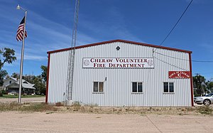
Cheraw, Colorado
Town in Otero County, Colorado, United States
Distance: Approx. 266 meters
Latitude and longitude: 38.108104,-103.510926
Cheraw is a Statutory Town located in Otero County, Colorado, United States. The town population was 237 at the 2020 United States Census.

La Junta Municipal Airport
Airport in Otero County, Colorado
Distance: Approx. 6492 meters
Latitude and longitude: 38.05,-103.50972222
La Junta Municipal Airport (ICAO: KLHX, FAA LID: LHX) is three miles north of La Junta, in Otero County, Colorado, United States. The National Plan of Integrated Airport Systems for 2011–2015 categorized it as a general aviation facility. Many U.S. airports use the same three-letter location identifier for the FAA and IATA, but this airport is LHX to the FAA and has no IATA code.
Weather in this IP's area
clear sky
2 Celsius
-3 Celsius
2 Celsius
2 Celsius
1003 hPa
52 %
1003 hPa
859 hPa
10000 meters
5.51 m/s
9.02 m/s
257 degree
