138.128.232.7 - IP Lookup: Free IP Address Lookup, Postal Code Lookup, IP Location Lookup, IP ASN, Public IP
Country:
Region:
City:
Location:
Time Zone:
Postal Code:
IP information under different IP Channel
ip-api
Country
Region
City
ASN
Time Zone
ISP
Blacklist
Proxy
Latitude
Longitude
Postal
Route
Luminati
Country
Region
co
City
trinidad
ASN
Time Zone
America/Denver
ISP
SECOM-1
Latitude
Longitude
Postal
IPinfo
Country
Region
City
ASN
Time Zone
ISP
Blacklist
Proxy
Latitude
Longitude
Postal
Route
IP2Location
138.128.232.7Country
Region
colorado
City
trinidad
Time Zone
America/Denver
ISP
Language
User-Agent
Latitude
Longitude
Postal
db-ip
Country
Region
City
ASN
Time Zone
ISP
Blacklist
Proxy
Latitude
Longitude
Postal
Route
ipdata
Country
Region
City
ASN
Time Zone
ISP
Blacklist
Proxy
Latitude
Longitude
Postal
Route
Popular places and events near this IP address
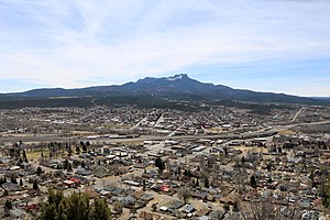
Trinidad, Colorado
City in Colorado, United States
Distance: Approx. 543 meters
Latitude and longitude: 37.17083333,-104.50638889
Trinidad is the home rule municipality that is the county seat and the most populous municipality of Las Animas County, Colorado, United States. The population was 8,329 as of the 2020 census. Trinidad lies 21 mi (34 km) north of Raton, New Mexico, and 195 mi (314 km) south of Denver.

Frank G. Bloom House
Historic house in Colorado, United States
Distance: Approx. 153 meters
Latitude and longitude: 37.16944444,-104.50222222
The Frank G. Bloom House or Bloom Mansion is located in Trinidad, Colorado, United States, which is within Las Animas County. The Bloom Mansion is a late 19th-century building meant to serve as the personal residence of its owner. The mansion is located in Trinidad's 300 block of Main Street and has been on the National Register of Historic Places since 1970.
Sopris, Colorado
Ghost town in Colorado, United States
Distance: Approx. 588 meters
Latitude and longitude: 37.16916667,-104.49388889
Sopris was an unincorporated community located in Las Animas County, Colorado, United States. The town is now under the surface of Trinidad Lake in Trinidad Lake State Park. The U.S. Post Office at Trinidad (ZIP Code 81082) now serves Sopris postal addresses.
Trinidad station (Colorado)
Train station in Trinidad, Colorado, United States
Distance: Approx. 782 meters
Latitude and longitude: 37.1732,-104.508
Trinidad station is a train station in Trinidad, Colorado served by Amtrak. It is served by Amtrak's Southwest Chief line. Trinidad station was originally built by the Atchison, Topeka and Santa Fe Railway, however it was not built in the Spanish Mission style, as many former Santa Fe Railroad stations were.

Trinidad History Museum
Distance: Approx. 186 meters
Latitude and longitude: 37.1695,-104.5026
Trinidad History Museum is a local history museum in Trinidad, Colorado, United States. It is administered by History Colorado (the Colorado Historical Society).
Temple Aaron
Historic synagogue in Trinidad, Colorado, US
Distance: Approx. 411 meters
Latitude and longitude: 37.16635,-104.50292
Temple Aaron, officially Temple Aaron of Colorado, is a Reform Jewish congregation and synagogue, located at 407 South Maple Street, in Trinidad, Colorado, in the United States. The temple is among the oldest synagogues in the state, and in December 2023 it was designated as a National Historic Landmark.
First Baptist Church (Trinidad, Colorado)
Historic church in Colorado, United States
Distance: Approx. 894 meters
Latitude and longitude: 37.17527778,-104.5075
The First Baptist Church in Trinidad, Colorado is a historic church at 809 San Pedro Street. It was built in 1890 and was added to the National Register of Historic Places in 2000. It is a "Romanesque-inspired" building with a T-shaped plan, built of local buff-colored sandstone upon a concrete foundation.
First Christian Church (Trinidad, Colorado)
Historic church in Colorado, United States
Distance: Approx. 68 meters
Latitude and longitude: 37.16888889,-104.50055556
First Christian Church (First Christian Community Church) is a historic church at 200 S. Walnut Street in Trinidad, Colorado. It was built in 1922 and was added to the National Register in 1995. It was designed by architects Isaac Rapp and Arthur C. Hendrickson.
First Methodist Episcopal Church (Trinidad, Colorado)
Historic church in Colorado, United States
Distance: Approx. 1045 meters
Latitude and longitude: 37.1735863,-104.5111014
The First Methodist Episcopal Church in Trinidad, Colorado, which has also been known as the First United Methodist Church, is a historic church at 216 Broom Street. It was built in 1911 and was added to the National Register in 2005. It was deemed "a good local example of an ecclesiastical interpretation of the Romanesque Revival style.
Baca House and Outbuilding
United States historic place
Distance: Approx. 181 meters
Latitude and longitude: 37.16916667,-104.5025
The Baca House and Outbuilding, in Trinidad, Colorado, was listed on the National Register of Historic Places in 1970. The Baca House is part of the Trinidad History Museum, which "features the historic Bloom Mansion and Baca House, two residences built in the late 19th century, as well as heritage gardens and the Santa Fe Trail Museum, all on one block in Trinidad's acclaimed historic district." It is a two-story adobe house having 10 rooms, which was home of rancher and businessman Felipe Baca. An adobe outbuilding includes 12 rooms, arranged in a 160 feet (49 m) long building, which housed ranch hands and visitors.
Jaffa Opera House
United States historic place
Distance: Approx. 453 meters
Latitude and longitude: 37.16805556,-104.50527778
The Jaffa Opera House, at 100–116 W. Main St. in Trinidad, Colorado, was built in 1883. It was listed on the National Register of Historic Places in 1972.
Corazon de Trinidad
United States historic place
Distance: Approx. 459 meters
Latitude and longitude: 37.16861111,-104.50555556
The Corazon de Trinidad is a historic district in Trinidad, Colorado which was listed on the National Register of Historic Places in 1973. The district is a 132 acres (53 ha) area roughly bounded by the Purgatoire River on the north and west, Walnut St. on the east, and 3rd, W. 1st and Animas Sts.
Weather in this IP's area
clear sky
5 Celsius
2 Celsius
5 Celsius
5 Celsius
1021 hPa
39 %
1021 hPa
796 hPa
10000 meters
4.63 m/s
260 degree


