138.118.253.61 - IP Lookup: Free IP Address Lookup, Postal Code Lookup, IP Location Lookup, IP ASN, Public IP
Country:
Region:
City:
Location:
Time Zone:
Postal Code:
IP information under different IP Channel
ip-api
Country
Region
City
ASN
Time Zone
ISP
Blacklist
Proxy
Latitude
Longitude
Postal
Route
Luminati
Country
Region
mt
City
querencia
ASN
Time Zone
America/Cuiaba
ISP
NET LINK INTERNET LTDA
Latitude
Longitude
Postal
IPinfo
Country
Region
City
ASN
Time Zone
ISP
Blacklist
Proxy
Latitude
Longitude
Postal
Route
IP2Location
138.118.253.61Country
Region
tocantins
City
palmas
Time Zone
America/Araguaina
ISP
Language
User-Agent
Latitude
Longitude
Postal
db-ip
Country
Region
City
ASN
Time Zone
ISP
Blacklist
Proxy
Latitude
Longitude
Postal
Route
ipdata
Country
Region
City
ASN
Time Zone
ISP
Blacklist
Proxy
Latitude
Longitude
Postal
Route
Popular places and events near this IP address

Tocantins
State of Brazil
Distance: Approx. 4429 meters
Latitude and longitude: -10.18333333,-48.33333333
Tocantins (Brazilian Portuguese: [tokɐ̃ˈtʃĩs] ) is one of the 26 states of Brazil. It is the newest state, formed in 1988 and encompassing what had formerly been the northern two-fifths of the state of Goiás. Tocantins covers 277,620.91 square kilometres (107,190.03 sq mi) and had an estimated population of 1,496,880 in 2014.

Palmas, Tocantins
Capital city of Tocantins, Brazil
Distance: Approx. 4318 meters
Latitude and longitude: -10.18444444,-48.33361111
Palmas (Brazilian Portuguese pronunciation: [ˈpawmɐs], Palm trees; Akwẽ-Xerénte: Akwẽ krikahâzawre wam hã [akwẽ kɾikahəʐawɾɛ wam hə̃]) is the capital and largest city of the state of Tocantins, Brazil. According to IBGE estimates from 2020, the city had 306,296 inhabitants. Palmas has a metropolitan area with 471,639 inhabitants.

Federal University of Tocantins
Academic publisher
Distance: Approx. 3655 meters
Latitude and longitude: -10.18004463,-48.36279523
The Federal University of Tocantins (Portuguese: Universidade Federal do Tocantins, UFT) is the public, federal university of the state of Tocantins, in Brazil. The university has campuses spread throughout the state, including in Araguaína, Arraias, Gurupi, Miracema, Palmas, Porto Nacional and Tocantinópolis.
Roman Catholic Archdiocese of Palmas
Catholic ecclesiastical territory
Distance: Approx. 4249 meters
Latitude and longitude: -10.1866,-48.3323
The Roman Catholic Archdiocese of Palmas (Latin: Archidioecesis Palmensis in Brasilia) is an archdiocese located in the city of Palmas in Brazil.

Palmas Airport
Airport
Distance: Approx. 8599 meters
Latitude and longitude: -10.29,-48.35777778
Palmas–Brigadeiro Lysias Rodrigues International Airport (IATA: PMW, ICAO: SBPJ) is the airport serving Palmas, Brazil. The airport is named after Brigadier Lysias Augusto Rodrigues (1896–1957), one of the founding figures of the Brazilian Air Force and crucial to the integration of Tocantins to Brazil via the passenger air services of the Brazilian Air Force.

Araguaia Palace
Distance: Approx. 4293 meters
Latitude and longitude: -10.18463169,-48.33373639
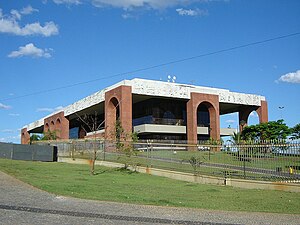
The Araguaia Palace is the seat of government of the Brazilian state of Tocantins. It is located in the city of Palmas, the state capital and its largest city. It was inaugurated on March 9, 1991.
Estádio Nilton Santos (Palmas)
Stadium in Brazil
Distance: Approx. 8354 meters
Latitude and longitude: -10.28186,-48.33065
The Estádio Nilton Santos is a stadium in Palmas, Tocantins, Brazil that is home to Palmas Futebol e Regatas, Capital Futebol Clube, Associação Desportiva e Recreativa São José, Tocantins Futebol Clube, and Tubarão Esporte Clube.

Sunflower Square
Square in Palmas, Brazil
Distance: Approx. 4300 meters
Latitude and longitude: -10.18458333,-48.33369444
The Sunflower Square (Portuguese: Praça dos Girassóis) is the main public square in the Brazilian city of Palmas, the capital of the state of Tocantins. It was inaugurated in 1991 and holds the Araguaia Palace, the seat of the Tocantins government. It is also one of the largest squares in the world.
Weather in this IP's area
broken clouds
28 Celsius
31 Celsius
28 Celsius
28 Celsius
1012 hPa
74 %
1012 hPa
985 hPa
10000 meters
2.06 m/s
75 %