138.117.99.128 - IP Lookup: Free IP Address Lookup, Postal Code Lookup, IP Location Lookup, IP ASN, Public IP
Country:
Region:
City:
Location:
Time Zone:
Postal Code:
ISP:
ASN:
language:
User-Agent:
Proxy IP:
Blacklist:
IP information under different IP Channel
ip-api
Country
Region
City
ASN
Time Zone
ISP
Blacklist
Proxy
Latitude
Longitude
Postal
Route
db-ip
Country
Region
City
ASN
Time Zone
ISP
Blacklist
Proxy
Latitude
Longitude
Postal
Route
IPinfo
Country
Region
City
ASN
Time Zone
ISP
Blacklist
Proxy
Latitude
Longitude
Postal
Route
IP2Location
138.117.99.128Country
Region
lempira
City
gracias
Time Zone
America/Tegucigalpa
ISP
Language
User-Agent
Latitude
Longitude
Postal
ipdata
Country
Region
City
ASN
Time Zone
ISP
Blacklist
Proxy
Latitude
Longitude
Postal
Route
Popular places and events near this IP address

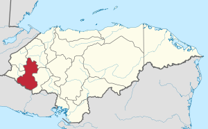
Lempira Department
Department in Honduras
Distance: Approx. 5 meters
Latitude and longitude: 14.58333333,-88.58333333
Lempira is one of the 18 departments in Honduras. located in the western part of the country, it is bordered by the departments of Ocotepeque and Copán to the west, Intibucá to the east, and Santa Bárbara to the north. To its south lies the El Salvador–Honduras border.

Gracias
Municipality in Lempira, Honduras
Distance: Approx. 639 meters
Latitude and longitude: 14.58888889,-88.58194444
Gracias (Spanish pronunciation: [ˈɡɾasjas]) is a small Honduran town/municipality that was founded in 1536, and is the capital of Lempira Department. The municipality has a population of 61,421 and the town a population of 18,550 (2023 calculation). It is located in the mountainous center of western Honduras.
Celaque Airport
Airport
Distance: Approx. 1728 meters
Latitude and longitude: 14.57361111,-88.59583333
Celaque Airport (IATA: GAC, ICAO: MHGS) is an airport serving the town of Gracias in Lempira Department, Honduras. The airport was inaugurated in 2013. There is high terrain southwest of the airport.

San Cristóbal fortress (Honduras)
Distance: Approx. 604 meters
Latitude and longitude: 14.5886,-88.5845
The San Cristóbal fortress is located in the city of Gracias, department of Lempira, built on a small hill above the city, which was formerly the center of the town of Gracias Lempira, which was once the capital of New Spain and headquarters of the Real Audiencia de los Confines in 1544; Gracias was a strategic city within the Province of Honduras in the colonial era, then in the pro-independence era and then in the Central American federal transition.
Weather in this IP's area
broken clouds
18 Celsius
18 Celsius
18 Celsius
18 Celsius
1019 hPa
88 %
1019 hPa
876 hPa
10000 meters
2.05 m/s
3.53 m/s
339 degree
83 %