138.0.17.150 - IP Lookup: Free IP Address Lookup, Postal Code Lookup, IP Location Lookup, IP ASN, Public IP
Country:
Region:
City:
Location:
Time Zone:
Postal Code:
IP information under different IP Channel
ip-api
Country
Region
City
ASN
Time Zone
ISP
Blacklist
Proxy
Latitude
Longitude
Postal
Route
Luminati
Country
Region
mg
City
belohorizonte
ASN
Time Zone
America/Sao_Paulo
ISP
V tal
Latitude
Longitude
Postal
IPinfo
Country
Region
City
ASN
Time Zone
ISP
Blacklist
Proxy
Latitude
Longitude
Postal
Route
IP2Location
138.0.17.150Country
Region
minas gerais
City
araxa
Time Zone
America/Sao_Paulo
ISP
Language
User-Agent
Latitude
Longitude
Postal
db-ip
Country
Region
City
ASN
Time Zone
ISP
Blacklist
Proxy
Latitude
Longitude
Postal
Route
ipdata
Country
Region
City
ASN
Time Zone
ISP
Blacklist
Proxy
Latitude
Longitude
Postal
Route
Popular places and events near this IP address
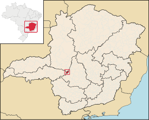
Araxá
Municipality in Brazil
Distance: Approx. 63 meters
Latitude and longitude: -19.59277778,-46.94083333
Araxá (Portuguese pronunciation: [aɾaˈʃa]) is a municipality in the state of Minas Gerais, in the Western Region of Brazil. It is located approximately 370 kilometers (230 miles) northwest of the state capital Belo Horizonte, with an area of 1,283 square kilometres (495 sq mi), and 3.45 square kilometres (1.33 sq mi) designated as the urban perimeter. As of 2022, the population is 111,691.
Araxá Airport
Airport
Distance: Approx. 3964 meters
Latitude and longitude: -19.56305556,-46.96055556
Romeu Zema Airport (IATA: AAX, ICAO: SBAX) is the airport serving Araxá, Brazil. It is named after Romeu Zema, a local entrepreneur.

Santa Rosa da Serra
Municipality in Southeast, Brazil
Distance: Approx. 7527 meters
Latitude and longitude: -19.53,-46.96583333
Santa Rosa da Serra is a Brazilian municipality located in the northwest of the state of Minas Gerais. Its population as of 2020 was 3,357 people living in a total area of 296 km2. The city belongs to the mesoregion of Triângulo Mineiro e Alto Paranaiba and to the microregion of Patos de Minas.

Companhia Brasileira de Metalurgia e Mineração
Mining company in Araxá, Brazil
Distance: Approx. 8845 meters
Latitude and longitude: -19.66684444,-46.90868056
Companhia Brasileira de Metalurgia e Mineração (Portuguese for Brazilian Metallurgy and Mining Company), or CBMM for short, is a Brazilian company that specializes in the processing and technology of niobium, extracted from its pyrochlore mine near the city of Araxá, in the Brazilian state of Minas Gerais. CBMM is by far the world's largest producer of niobium metal and its alloys, providing over 80% of the world's supply. Like the other producers of this metal, the company does not sell raw niobium ore, only ferroniobium, other niobium alloys and oxides, and the pure metal, all produced in its facilities next to the open-pit mine.
Weather in this IP's area
broken clouds
17 Celsius
17 Celsius
17 Celsius
17 Celsius
1013 hPa
98 %
1013 hPa
903 hPa
10000 meters
0.83 m/s
0.9 m/s
11 degree
59 %
