Country:
Region:
City:
Latitude and Longitude:
Time Zone:
Postal Code:
IP information under different IP Channel
ip-api
Country
Region
City
ASN
Time Zone
ISP
Blacklist
Proxy
Latitude
Longitude
Postal
Route
Luminati
Country
ASN
Time Zone
Asia/Bangkok
ISP
MOBIFONE Corporation
Latitude
Longitude
Postal
IPinfo
Country
Region
City
ASN
Time Zone
ISP
Blacklist
Proxy
Latitude
Longitude
Postal
Route
db-ip
Country
Region
City
ASN
Time Zone
ISP
Blacklist
Proxy
Latitude
Longitude
Postal
Route
ipdata
Country
Region
City
ASN
Time Zone
ISP
Blacklist
Proxy
Latitude
Longitude
Postal
Route
Popular places and events near this IP address

Hanoi
Capital of Vietnam
Distance: Approx. 2036 meters
Latitude and longitude: 21,105.85
Hanoi (Vietnamese: Hà Nội ) is the capital and second-most populous city of Vietnam. The name "Hanoi" translates to "inside the river," – Hanoi is bordered by the Red and Black Rivers. As a municipality, Hanoi consists of 12 urban districts, 17 rural districts, and one district-level town.
Institut de la Francophonie pour l'Informatique
Graduate computer science school in Vietnam
Distance: Approx. 2282 meters
Latitude and longitude: 21.0031,105.8477
The Institut de la Francophonie pour l'Informatique (IFI), French for the "Computer Science Institute for the Francophonie", is a graduate school in computer science in Vietnam. It was created and funded by the Agence universitaire de la Francophonie (AUF) in 1995 following a request from the Vietnamese government for the training of high-level Vietnamese engineers and college professors in computer science. The countries and regions funding the project are Wallonia, Belgium; Québec, Canada; France; French-speaking Switzerland; and Luxembourg.

Bạch Mai Hospital
Hospital in Hanoi, Vietnam
Distance: Approx. 1975 meters
Latitude and longitude: 21.001,105.8407
Bach Mai Hospital is a multi-field medical facility in Hanoi and is considered one of the largest in Vietnam. The hospital was established in 1911 during the French colonial rule. It has played an important role in the health system of Vietnam and is one of three high specialized medical centers, specializing in internal medicine.
Hôpital français de Hanoï
Hospital in Hanoi, Vietnam
Distance: Approx. 2264 meters
Latitude and longitude: 21.00361111,105.84083333
The Hôpital français de Hanoï (English: French Hospital of Hanoi, Vietnamese: Bệnh viện Pháp của Hà Nội), known in Vietnam under the name Bệnh viện Việt Pháp, formerly the Viet Nam International Hospital, is a privatised hospital in Hanoi, Vietnam, sold to a French company in September 2000. It is located at 1 Phuong Mai, Dong Da, Hanoi. Its staff include French and Vietnamese doctors.
Mai Hương Hospital
Hospital in Hanoi, Vietnam
Distance: Approx. 1978 meters
Latitude and longitude: 20.9988,105.8513
Mai Huong Hospital (or Mai Huong Day Psychiatric Hospital) - a hospital in Hanoi (Vietnam) specialized in mental health. The hospital provides psychotherapy, medical treatment, consultations, rehabilitation services and is sponsored by Centre for International Mental Health of the University of Melbourne. The programs for free mental check-ups and counselling for students and schoolchildren are regularly held.

Hoàng Mai district, Hanoi
Urban district in Hanoi, Vietnam
Distance: Approx. 1820 meters
Latitude and longitude: 20.96805556,105.84833333
Hoàng Mai is an urban district (quận) of Hanoi, the capital city of Vietnam.

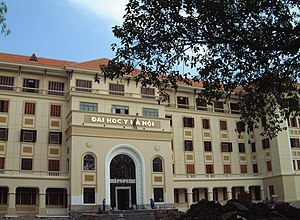
Hanoi Medical University
Distance: Approx. 2420 meters
Latitude and longitude: 21.00277778,105.83166667
Hanoi Medical University (HMU, Vietnamese: Trường Đại học Y Hà Nội) is the oldest university of Vietnam and is located in Hanoi. HMU was founded in 1902 by French during the French colonisation under the name Indochina Medical College. The first headmaster of HMU was Alexandre Yersin who was the co-discoverer of the bacillus responsible for the bubonic plague or pest, which was renamed in his honour (Yersinia pestis).
Vietnam People's Air Force Museum, Hanoi
Museum in Hanoi, Vietnam
Distance: Approx. 2263 meters
Latitude and longitude: 20.99972222,105.82916667
The Vietnam People's Air Force Museum, Hanoi or Bảo Tàng Phòng Không - Không Quân is located on Truong Chinh Street in the Bach Mai District of Hanoi. The museum is on the edge of the disused Bach Mai Airfield. The museum tells the history of the Vietnam People's Air Force (VPAF) from its formation in 1954 through to the present day.

Bach Mai Airfield
Airport in Hanoi
Distance: Approx. 1818 meters
Latitude and longitude: 20.996667,105.831944
Bach Mai Airfield (Vietnamese: Sân bay Bach Mai) is a disused military airport in Thanh Xuan District, Hanoi, Vietnam, located along modern-day Le Trong Tan street. It was constructed by the French in 1917 and used by French forces until 1954; along with Gia Lam Airbase, it was one of the major logistics bases supporting French operations at Dien Bien Phu. After 1954, it was used by the Vietnamese People's Air Force and served as their air defense command and control center during the Second Indochina War, playing a part in the Cambodian–Vietnamese War as well.
National Economics University
Distance: Approx. 1851 meters
Latitude and longitude: 20.999722,105.844814
National Economics University (NEU; Vietnamese: Trường Đại học Kinh tế Quốc dân) is a public research university in Hanoi, Vietnam. Founded in 1956, its history and influence have made it the leading universities in Economics, Public Administration and Business Administration in Vietnam. NEU is now chairing a network of more than 40 universities in Vietnam in economics and business administration.

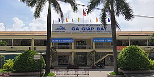
Giáp Bát station
Railway station in Hoàng Mai, Vietnam
Distance: Approx. 560 meters
Latitude and longitude: 20.9785,105.8404
Giáp Bát station is a railway station on the North–South railway (Reunification Express) in Vietnam. It serves the city of Hanoi.

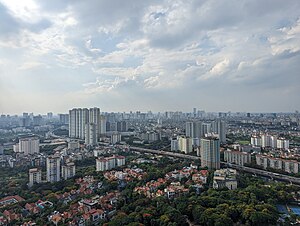
Linh Đàm
Neighborhood and Planning Area in Hoàng Mai, Hanoi, Vietnam
Distance: Approx. 1853 meters
Latitude and longitude: 20.9675,105.83638889
Linh Đàm is a neighborhood located in Hoàng Mai district, Hanoi. With a population of about 80,000 people, Linh Đàm is among the most densely populated neighborhoods in Vietnam. First settled in around the early 1600s, the area was mostly a swamp and sparsely-populated area until the early 1990s, when it was planned to relieve overpopulation in the urban core of Hanoi.
Weather in this IP's area
broken clouds
20 Celsius
20 Celsius
20 Celsius
20 Celsius
1014 hPa
64 %
1014 hPa
1012 hPa
10000 meters
1.08 m/s
1.32 m/s
134 degree
69 %
06:04:41
17:16:46