Country:
 Great Britain
Region:
City:
Latitude and Longitude:
Time Zone:
Postal Code:
IP information under different IP Channel
ip-api
Country
Region
City
ASN
Time Zone
ISP
Blacklist
Proxy
Latitude
Longitude
Postal
Route
IPinfo
Country
Region
City
ASN
Time Zone
ISP
Blacklist
Proxy
Latitude
Longitude
Postal
Route
MaxMind
Country
Region
City
ASN
Time Zone
ISP
Blacklist
Proxy
Latitude
Longitude
Postal
Route
Luminati
Country
GBRegion
eng
City
swanscombe
ASN
Time Zone
Europe/London
ISP
Convergence (group Networks) Limited
Latitude
Longitude
Postal
db-ip
Country
Region
City
ASN
Time Zone
ISP
Blacklist
Proxy
Latitude
Longitude
Postal
Route
ipdata
Country
Region
City
ASN
Time Zone
ISP
Blacklist
Proxy
Latitude
Longitude
Postal
Route
Popular places and events near this IP address
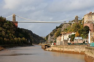
Clifton Suspension Bridge
Bridge spanning the Avon Gorge and the River Avon
Distance: Approx. 1640 meters
Latitude and longitude: 51.4549,-2.6279
The Clifton Suspension Bridge is a suspension bridge spanning the Avon Gorge and the River Avon, linking Clifton in Bristol to Leigh Woods in North Somerset. Since opening in 1864, it has been a toll bridge, the income from which provides funds for its maintenance. The bridge is built to a design by William Henry Barlow and John Hawkshaw, based on an earlier design by Isambard Kingdom Brunel.

Ashton Court
Mansion house and estate to the west of Bristol in England
Distance: Approx. 471 meters
Latitude and longitude: 51.4479,-2.6446
Ashton Court is a mansion house and estate to the west of Bristol in England. Although the estate lies mainly in North Somerset, it is owned by the City of Bristol. The mansion and stables are a Grade I listed building.

Avon Gorge
Gorge on the River Avon in Bristol, England
Distance: Approx. 1640 meters
Latitude and longitude: 51.4549,-2.6279
The Avon Gorge (grid reference ST560743) is a 1.5-mile (2.5-kilometre) long gorge on the River Avon in Bristol, England. The gorge runs south to north through a limestone ridge 1.5 miles (2.4 km) west of Bristol city centre, and about 3 miles (5 km) from the mouth of the river at Avonmouth. The gorge forms the boundary between the unitary authorities of North Somerset and Bristol, with the boundary running along the south bank.

Abbots Leigh
Village in Somerset, England
Distance: Approx. 1243 meters
Latitude and longitude: 51.4607,-2.6564
Abbots Leigh is a village and civil parish in North Somerset, England, about 3 miles (5 km) west of the centre of Bristol.

Leigh Woods National Nature Reserve
National nature reserve near Bristol, England
Distance: Approx. 1629 meters
Latitude and longitude: 51.4631,-2.6392
Leigh Woods is a 2-square-kilometre (0.77 sq mi) area of woodland on the south-west side of the Avon Gorge, close to the Clifton Suspension Bridge, within North Somerset opposite the English city of Bristol and north of the Ashton Court estate, of which it formed a part. Stokeleigh Camp, a hillfort thought to have been occupied from the third century BC to the first century AD and possibly also in the Middle Ages, lies within the reserve on the edge of the Nightingale Valley. On the bank of the Avon, within the reserve, are quarries for limestone and celestine which were worked in the 18th and 19th centuries are now derelict.
Nightingale Valley Halt railway station
Former railway station in England
Distance: Approx. 1535 meters
Latitude and longitude: 51.4561,-2.6303
Nightingale Valley Halt was a railway station near Bristol, England, on the Portishead Railway. It was situated approximately 190 metres north-west of the Clifton Suspension Bridge, and was for the benefit of visitors to Leigh Woods. It opened on 9 July 1928, and closed on 12 September 1932.

Kite Festival
Annual event in Bristol, England
Distance: Approx. 944 meters
Latitude and longitude: 51.4437,-2.64157
The Bristol International Kite Festival, full name Bristol International Festival of Kites & Air Creations, used to be held annually during September in Bristol, England. It takes place at the Ashton Court estate, which is owned by Bristol City Council, although it is actually in the district of North Somerset. The festival started in 1986 and celebrated its 25th anniversary in 2011.
Gane Pavilion
Temporary building (1936) near Bristol by Marcel Breuer
Distance: Approx. 471 meters
Latitude and longitude: 51.4479,-2.6446
The Gane Pavilion, also known as Gane's Pavilion, the Gane Show House and the Bristol Pavilion, was a temporary building designed by the modernist architect and furniture designer Marcel Breuer with F. R. S. Yorke and built in 1936 at Ashton Court near Bristol in England.

Stokeleigh Camp
Iron Age promontory fort in Somerset, England
Distance: Approx. 1163 meters
Latitude and longitude: 51.45694444,-2.6375
Stokeleigh Camp is an Iron Age promontory fort in Leigh Woods North Somerset near Bristol, England. The hill fort is one of three Iron Age fortifications overlooking the Avon Gorge, the others being Burgh Walls Camp south of the Nightingale Valley, of which almost no trace remains, and the other being Clifton Down Camp on the opposite side of the gorge, on Clifton Down near the Observatory. A prehistoric road is believed to have connected Stokeleigh Camp with Cadbury Camp near Tickenham in North Somerset.
Burgh Walls Camp
Iron Age hillfort in Somerset, England
Distance: Approx. 1460 meters
Latitude and longitude: 51.45194444,-2.62944444
Burgh Walls Camp is a multivallate Iron Age hill fort in the North Somerset district of Somerset, England. The hill fort is situated within Leigh Woods approximately 1.6 miles (2.6 km) north-east from the village of Long Ashton near Bristol, above the banks of the River Avon. The hillfort has some alternative names such as Bower Walls Camp, Burwalls, or Bowre Walls.

Leigh Woods, Somerset
Village in Somerset, England
Distance: Approx. 1040 meters
Latitude and longitude: 51.453,-2.636
Leigh Woods is a village in the North Somerset district of Somerset, England. It is just outside the boundary of the city and county of Bristol. The village is located to the south of Leigh Woods National Nature Reserve.

Holy Trinity Church, Abbots Leigh
Church in Somerset, England
Distance: Approx. 1535 meters
Latitude and longitude: 51.4633,-2.6572
Holy Trinity Church in Abbots Leigh within the English county of Somerset is a 15th-century Perpendicular Gothic building, restored and partially rebuilt in 1847–48 after a fire. It is a Grade II* listed building.
Weather in this IP's area
overcast clouds
11 Celsius
10 Celsius
10 Celsius
12 Celsius
1015 hPa
96 %
1015 hPa
1000 hPa
10000 meters
3.6 m/s
190 degree
100 %
07:39:56
18:11:07