Country:
 Canada
Region:
City:
Latitude and Longitude:
Time Zone:
Postal Code:
IP information under different IP Channel
ip-api
Country
Region
City
ASN
Time Zone
ISP
Blacklist
Proxy
Latitude
Longitude
Postal
Route
IPinfo
Country
Region
City
ASN
Time Zone
ISP
Blacklist
Proxy
Latitude
Longitude
Postal
Route
MaxMind
Country
Region
City
ASN
Time Zone
ISP
Blacklist
Proxy
Latitude
Longitude
Postal
Route
Luminati
Country
CARegion
qc
City
terrebonne
ASN
Time Zone
America/Toronto
ISP
VIDEOTRON
Latitude
Longitude
Postal
db-ip
Country
Region
City
ASN
Time Zone
ISP
Blacklist
Proxy
Latitude
Longitude
Postal
Route
ipdata
Country
Region
City
ASN
Time Zone
ISP
Blacklist
Proxy
Latitude
Longitude
Postal
Route
Popular places and events near this IP address

Lachenaie, Quebec
Human settlement in Terrebonne, Quebec, Canada
Distance: Approx. 1528 meters
Latitude and longitude: 45.71488889,-73.51608333
Lachenaie was an off-island suburb of Montreal, in southwestern Quebec, Canada on the Rivière des Mille-Îles. It is now part of the city of Terrebonne, and is in the Regional County Municipality of Les Moulins. In 2001, the population was 21,709.

Charlemagne, Quebec
City in Quebec, Canada
Distance: Approx. 4081 meters
Latitude and longitude: 45.71666667,-73.48333333
Charlemagne (pronounced [ʃaʁləmaɲ]) is a city in the Province of Québec, Canada, on the north shore of the Rivière des Prairies, 24 kilometres (15 mi) northeast of the city of Montréal’s downtown core. As of 2021, the population was 6,302. Charlemagne is, famously, the birthplace and childhood hometown of singer Céline Dion, best known for the song "My Heart Will Go On" from the 1997 film Titanic; the town council named one of its main streets after her without the recognition of a Québec commission.

L'Assomption River
River in Quebec, Canada
Distance: Approx. 4265 meters
Latitude and longitude: 45.71444444,-73.48083333
The Assomption River (in French Rivière l'Assomption, named after the Assumption of Mary) is the most important waterway in the Lanaudière region of Quebec, Canada. It is over 200 kilometres (120 mi) long, and has a drainage basin (watershed) of 4,220 square kilometres (1,630 sq mi). Its source is the Mont Tremblant massif.
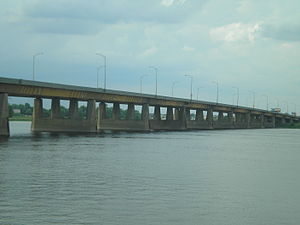
Le Gardeur Bridge
Bridge in Montreal
Distance: Approx. 4211 meters
Latitude and longitude: 45.70361111,-73.48361111
The Le Gardeur Bridge is a beam bridge that connects the east end of the island of Montreal, in Pointe-aux-Trembles, to Repentigny. The bridge has two sections across the Rivière des Prairies, which are separated by Île Bourdon. The length of the structures is 297 metres (974 ft) (west) and 565 metres (1,854 ft) (east).
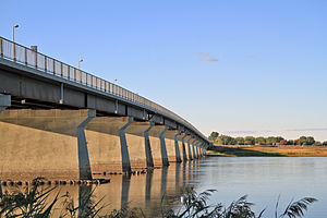
Charles de Gaulle Bridge
Bridge in between Montreal and Terrebonne
Distance: Approx. 2479 meters
Latitude and longitude: 45.70194444,-73.50888889
The Charles de Gaulle Bridge is a bridge that links the eastern tip of the island of Montreal, Quebec over the Rivière des Prairies to the Lanaudière region near the city of Charlemagne. The bridge is named after French President Charles de Gaulle, who inspired the Quebec sovereignty movement in the 1960s with his Vive le Québec libre speech in Montreal in 1967, the same year the bridge was built. The bridge is part of Quebec Autoroute 40 and is only one of two bridge crossings from Montreal to the Repentigny-Charlemagne region, the other being Pierre Le Gardeur Bridge, on Notre-Dame Street.

Laurier Railway Bridge
Bridge in Montreal
Distance: Approx. 4093 meters
Latitude and longitude: 45.70277778,-73.48555556
The Laurier Railway Bridge (often referred to as Pierre Le Gardeur railway bridge, after the road bridge next to it) carries the Canadian National Railway from Montreal (Rivière-des-Prairies–Pointe-aux-Trembles) to Charlemagne (North Shore) via Île Bourdon.

Lachenaie landfill
Distance: Approx. 3266 meters
Latitude and longitude: 45.7223,-73.576
The Lachenaie landfill is located in Terrebonne, Quebec, on the north-eastern shore of Montreal. Along with the Ste. Sophie landfill, these two sites collect garbage for the Greater Montreal Area.

Coulée Grou
Site of a battle of the Beaver Wars in Montreal, Quebec, Canada
Distance: Approx. 2995 meters
Latitude and longitude: 45.698909,-73.5038
Coulée Grou is the name of an area in Montreal, Quebec, Canada, that was the location of a battle of the Beaver Wars, also known as the Iroquois Wars, given in honor of Jean Grou, a Canadian pioneer. Grou had sailed as a young boy from Rouen in France (Normandy) to New France (French: Nouvelle-France) circa 1650–1665 and established a land-holding at Rivière-des-Prairies–Pointe-aux-Trembles, east of the modern city of Montreal. At a battle here on 2 July 1690, Jean Grou and three farm workers were captured and burned alive.

Repentigny station
Railway station in Quebec, Canada
Distance: Approx. 4558 meters
Latitude and longitude: 45.73555556,-73.48583333
Repentigny station is a commuter rail station operated by Exo in Repentigny, Quebec, Canada, a suburb north of Montreal. It is served by the Mascouche line. The station possesses a single side platform, although two rails pass through it; the second is used for non-stopping main line traffic.

Terrebonne station
Railway station in Quebec, Canada
Distance: Approx. 1945 meters
Latitude and longitude: 45.72833333,-73.52138889
Terrebonne station is a commuter rail station operated by Exo in Terrebonne, Quebec, Canada. It is served by the Mascouche line. Despite its name, it is located some 9 km from the town centre of Terrebonne, instead serving the district of Lachenaie, a former municipality that was merged with Terrebonne in 2001.

Pointe-aux-Prairies Nature Park
Large nature park in Montreal, Canada
Distance: Approx. 3815 meters
Latitude and longitude: 45.6833,-73.5139
Pointe-aux-Prairies Nature Park is a large nature park in the Rivière-des-Prairies–Pointe-aux-Trembles borough of Montreal, Quebec, Canada. The park is divided into three sections. The northern part is between Gouin Boulevard East and Autoroute 40.
École secondaire Pointe-aux-Trembles
School in Quebec.
Distance: Approx. 4378 meters
Latitude and longitude: 45.6853,-73.4972
École secondaire de la Pointe-aux-Trembles is a francophone secondary public school located on Sherbrooke East street in the district of Pointe-aux-Trembles, Quebec in Montreal. Part of the Commission scolaire de la Pointe-de-l'Île, it was originally in the Roman Catholic Commission scolaire Jérôme-Le Royer before the 1998 reorganization of school boards from religious communities to linguistic communities in Quebec. This school hosts 1,261 students from sec 1 to 5 (grade 7 to 11) and 90 teachers.
Weather in this IP's area
few clouds
5 Celsius
5 Celsius
3 Celsius
6 Celsius
1011 hPa
93 %
1011 hPa
1010 hPa
10000 meters
0.51 m/s
230 degree
16 %
07:01:50
18:20:57