Country:
 Canada
Region:
City:
Latitude and Longitude:
Time Zone:
Postal Code:
IP information under different IP Channel
ip-api
Country
Region
City
ASN
Time Zone
ISP
Blacklist
Proxy
Latitude
Longitude
Postal
Route
IPinfo
Country
Region
City
ASN
Time Zone
ISP
Blacklist
Proxy
Latitude
Longitude
Postal
Route
MaxMind
Country
Region
City
ASN
Time Zone
ISP
Blacklist
Proxy
Latitude
Longitude
Postal
Route
Luminati
Country
CARegion
qc
City
longueuil
ASN
Time Zone
America/Toronto
ISP
VIDEOTRON
Latitude
Longitude
Postal
db-ip
Country
Region
City
ASN
Time Zone
ISP
Blacklist
Proxy
Latitude
Longitude
Postal
Route
ipdata
Country
Region
City
ASN
Time Zone
ISP
Blacklist
Proxy
Latitude
Longitude
Postal
Route
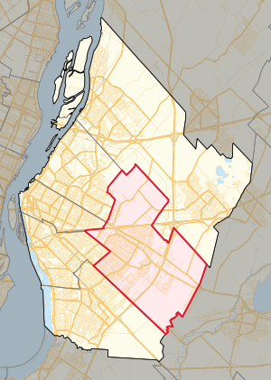
Popular places and events near this IP address
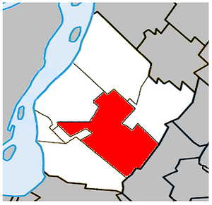
Saint-Hubert, Quebec
Borough of Longueuil in Quebec, Canada
Distance: Approx. 867 meters
Latitude and longitude: 45.4825,-73.41972222
Saint-Hubert ( - HEW-bərt, French: [sɛ̃t‿ybɛʁ] , locally [sẽɪ̯̃t͡s‿ybaɛ̯ʁ]) is a borough in the city of Longueuil, located in the Montérégie region of Quebec, Canada. It had been a separate city prior to January 1, 2002, when it along with several other neighbouring south shore municipalities were merged into Longueuil. Saint-Hubert had a population of 78,336 in 2006.
John H. Chapman Space Centre
Distance: Approx. 3996 meters
Latitude and longitude: 45.5198,-73.3936
The John H. Chapman Space Centre (French: Centre Spatial John H. Chapman) is the headquarters of the Canadian Space Agency. It is located in Longueuil, Quebec, Canada, in the borough of Saint-Hubert.

Brossard
City in Quebec, Canada
Distance: Approx. 3799 meters
Latitude and longitude: 45.46666667,-73.45
Brossard ( bross-AR, BROSS-ard, French: [bʁɔsaʁ], locally [bʁɔsɑːʁ, bʁɔsɑɔ̯ʁ]) is a municipality in the Montérégie region of Quebec, Canada and is part of the Greater Montreal area. According to the 2021 census, Brossard's population was 91,525. It shares powers with the urban agglomeration of Longueuil and was a borough of the municipality of Longueuil from 2002 to 2006.

MET – Montreal Metropolitan Airport
Airport in the Saint-Hubert borough of Longueuil, Quebec, Canada
Distance: Approx. 3647 meters
Latitude and longitude: 45.51805556,-73.41694444
MET – Montreal Metropolitan Airport (IATA: YHU, ICAO: CYHU) (French: MET – Aéroport métropolitain de Montréal), formerly known as Montréal Saint-Hubert - Longueuil Airport (Aéroport Montréal Saint-Hubert - Longueuil) or Montréal/Saint-Hubert Airport, and still commonly referred to as St-Hubert airport, is located in the Saint-Hubert borough of Longueuil, Quebec. The airport is located 16 km (9.9 mi) east of Downtown Montreal and 3 nautical miles (5.6 km; 3.5 mi) east of downtown Longueuil. As of 2023, it is ranked as Canada's 12th busiest airport by aircraft movements.
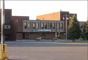
Centennial Regional High School
School in Greenfield Park , Quebec, Canada
Distance: Approx. 2891 meters
Latitude and longitude: 45.49111111,-73.44583333
Centennial Regional High School (CRHS, French: École secondaire régionale Centennial) is an English-language co-educational comprehensive public high school located in the Greenfield Park borough of Longueuil, Quebec, Canada, a suburb of Montreal. It was opened in 1972 and named to commemorate the centennial anniversary of Canada's confederation. The school's student body is culturally diverse.
Promenades Saint-Bruno
Shopping mall
Distance: Approx. 3263 meters
Latitude and longitude: 45.5053,-73.3785
Promenades St-Bruno (corporately known as CF Promenades St-Bruno) is a two-level shopping mall located in Saint-Bruno-de-Montarville, Quebec, Canada. Ground was broken in the spring of 1977 to build the mall and it was completed in August 1978. Les Promenades St-Bruno is the largest mall in the Montérégie and part of its consumer base come from cities as far as Saint-Hyacinthe and Sorel-Tracy.
Vachon (electoral district)
Provincial electoral district in Quebec, Canada
Distance: Approx. 889 meters
Latitude and longitude: 45.49,-73.4
Vachon is a provincial electoral district in the Montérégie region of Quebec, Canada that elects members to the National Assembly of Quebec. It is located within the city of Longueuil and includes most of the borough of Saint-Hubert. It was created for the 1981 election from a part of Taillon electoral district and is named after early Quebec aviation pioneer Roméo Vachon, who worked at Trans-Canada Airlines; the district includes Montréal/Saint-Hubert Airport.
Heritage Regional High School
Secondary school in Montreal, Quebec, Canada
Distance: Approx. 1520 meters
Latitude and longitude: 45.49,-73.39111111
Heritage Regional High School (HRHS) is a public secondary school located in Longueuil, Quebec, Canada. It was formed in the 2003 merger of Macdonald-Cartier High School of Saint-Hubert, Quebec, with Richelieu Valley Regional High School of McMasterville, Quebec.
Notre-Dame-du-Sacré-Cœur
Distance: Approx. 3764 meters
Latitude and longitude: 45.474427,-73.455062
Notre-Dame-du-Sacré-Cœur (also known as Notre-Dame) was a small municipality in southwestern Quebec, Canada, three kilometers (2 miles) from the southern shore of the Saint Lawrence River. It was a suburb of Montreal until it was annexed to the city of Brossard in 1978. The boundaries of Notre-Dame-du-Sacré-Coeur were fairly simple as the municipality had the exact shape of a rectangle.

Longueuil–Saint-Hubert station
Railway station in Quebec, Canada
Distance: Approx. 3195 meters
Latitude and longitude: 45.50805556,-73.43527778
Longueuil–Saint-Hubert station is a commuter rail station operated by Exo in the Saint-Hubert borough of Longueuil, Quebec, Canada. It is served by the Mont-Saint-Hilaire line.

Parc de la Cité
Distance: Approx. 58 meters
Latitude and longitude: 45.486,-73.409
Parc de la Cité, is a large park in Longueuil, Quebec, Canada. It is located at 6205 Davis Boulevard in the borough of Saint-Hubert.

Parc René-Veillet
Park in Canada
Distance: Approx. 3312 meters
Latitude and longitude: 45.48592,-73.45204
René-Veillet Park, located at #1050 Parklane Street in the heart of the Greenfield Park borough of Longueuil, in Quebec, Canada has a set of amenities for sports and other types of recreation. The plans for the Parklane Cottage (now renamed "Centre sportif René-Veillet") were designed in 1973. The park was developed in 1974-75, as well as the recreation center.
Weather in this IP's area
clear sky
4 Celsius
4 Celsius
2 Celsius
6 Celsius
1011 hPa
94 %
1011 hPa
1008 hPa
10000 meters
1.03 m/s
07:01:09
18:20:37