Country:
 Spain
SpainRegion:
City:
Latitude and Longitude:
Time Zone:
Postal Code:
IP information under different IP Channel
ip-api
Country
Region
City
ASN
Time Zone
ISP
Blacklist
Proxy
Latitude
Longitude
Postal
Route
IPinfo
Country
Region
City
ASN
Time Zone
ISP
Blacklist
Proxy
Latitude
Longitude
Postal
Route
MaxMind
Country
Region
City
ASN
Time Zone
ISP
Blacklist
Proxy
Latitude
Longitude
Postal
Route
Luminati
Country
ESRegion
ct
City
barcelona
ASN
Time Zone
Europe/Madrid
ISP
Equinix (EMEA) Acquisition Enterprises B.V.
Latitude
Longitude
Postal
db-ip
Country
Region
City
ASN
Time Zone
ISP
Blacklist
Proxy
Latitude
Longitude
Postal
Route
ipdata
Country
Region
City
ASN
Time Zone
ISP
Blacklist
Proxy
Latitude
Longitude
Postal
Route
Popular places and events near this IP address

Gran Via de les Corts Catalanes
Thoroughfare in Barcelona, Spain
Distance: Approx. 227 meters
Latitude and longitude: 41.38888889,2.17111111
Gran Via de les Corts Catalanes ("Great Way of the Catalan Courts"), more simply known as Gran Via [ˈɡɾam ˈbi.ə], is one of Barcelona's major avenues. With a length of 13.1 km (8.1 mi), it is the longest street in Catalonia and the 2nd longest in Spain, after Gran Vía de la Manga, in La Manga del Mar Menor, but is the one with most street numbers in Spain.

Barcelona Metro line 1
Rapid transit line in Barcelona, Spain
Distance: Approx. 8 meters
Latitude and longitude: 41.387,2.17
Line 1, shortened to L1, coloured red and often simply called Línia vermella ("Red Line"), is the second oldest Barcelona Metro line, after line L3. It is the longest line of the Barcelona Metro, and links L'Hospitalet de Llobregat and Santa Coloma de Gramenet. Originally operated by the independent Ferrocarril Metropolitano Transversal de Barcelona, it is today operated by Transports Metropolitans de Barcelona (TMB) and is part of the ATM fare-integrated main transport system.

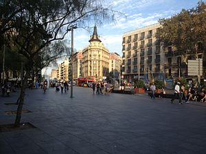
Plaça de Catalunya
Public square in Barcelona, Spain
Distance: Approx. 38 meters
Latitude and longitude: 41.38666667,2.17
Plaça de Catalunya (pronounced [ˈplasə ðə kətəˈluɲə], meaning in English "Catalonia Square"; sometimes referred to as Plaza de Cataluña, its Spanish name) is a large square in central Barcelona that is generally considered to be both its city centre and the place where the old city (see Barri Gòtic and Raval, in Ciutat Vella) and the 19th century-built Eixample meet. Some of the city's most important streets and avenues meet at Plaça Catalunya: Passeig de Gràcia, Rambla de Catalunya, La Rambla, and Portal de l'Àngel, in addition to Ronda de Sant Pere, Carrer de Vergara, and Carrer de Pelai. The plaza occupies an area of about 50,000 square metres.

Portal de l'Àngel
Thoroughfare in Barcelona, Spain
Distance: Approx. 158 meters
Latitude and longitude: 41.38666667,2.17194444
Portal de l'Àngel (Catalan pronunciation: [puɾˈtal də ˈlaɲʒəl]) is a pedestrian street in the Ciutat Vella district of Barcelona adjacent to Plaça Catalunya and part of the large shopping area that spans from Avinguda Diagonal to Barri Gòtic. It's one of the city's most visited streets and is always crowded with tourists and locals all year round. Portal de l'Àngel is noteworthy for being the most expensive street in Spain, with an average rental price of €265 per square meter in 2013.

Plaça de Catalunya station
Barcelona Metro station
Distance: Approx. 10 meters
Latitude and longitude: 41.38694444,2.17
Plaça de Catalunya station, also known as Barcelona-Plaça Catalunya, Plaça Catalunya or simply Catalunya is a major station complex in Barcelona located under Plaça de Catalunya, the city's central square and a large transport hub. Many Rodalies de Catalunya, Barcelona Metro and Ferrocarrils de la Generalitat de Catalunya lines go through it and many bus routes link it with all of the districts of the city and most of the municipalities in its metropolitan area. It is one of the oldest railway stations in Catalonia and one of the first stations of Barcelona Metro network.
Ronda de la Universitat, Barcelona
Distance: Approx. 269 meters
Latitude and longitude: 41.3867,2.1669
Ronda de la Universitat is a major thoroughfare of central Barcelona, Catalonia, Spain, in lower side of the Dreta de l'Eixample, in the Eixample district. It links two of the city's three main squares, running from Plaça de Catalunya towards Plaça Universitat. There it meets Gran Via de les Corts Catalanes and Ronda de Sant Antoni begins.

Carrer de Pelai, Barcelona
Street in Barcelona, Catalonia, Spain
Distance: Approx. 239 meters
Latitude and longitude: 41.38607,2.16752
Carrer de Pelai (official Catalan name; sometimes called, in Spanish, Calle de Pelayo) is a major shopping street in Barcelona, one of the busiest in the city at daytime. It forms the border between the districts of Ciutat Vella and Eixample in the center of the city, and runs from the intersection of Plaça de Catalunya with La Rambla and the El Triangle shopping centre to Plaça de la Universitat. It is named after King Pelagius of Asturias.

Carrer de Bergara, Barcelona
Street in Barcelona, Catalonia, Spain
Distance: Approx. 182 meters
Latitude and longitude: 41.3862,2.1682
Carrer de Bergara (sometimes, but not officially, Vergara, using the Spanish spelling of the Basque name) is a short street in central Barcelona, stretching from Plaça Catalunya towards Carrer de Pelai. It's in the Eixample district. It's named after the Basque city of Bergara, where an armistice was signed at the end the First Carlist War in 1839.

Font de Canaletes
Fountain in Barcelona, Spain
Distance: Approx. 192 meters
Latitude and longitude: 41.38527778,2.17013889
Font de Canaletes (Spanish: Fuente de Canaletas) is an ornate fountain, crowned by a lamp post, in Barcelona, Catalonia, in Rambla de Canaletes, the upper part of La Rambla, near Plaça de Catalunya. It is a fixture of football fans after Barça football matches since the 1930s. Tradition has that the one who drinks from the Font de Canaletes will come back to Barcelona, as the inscription on the floor suggests.

Avinguda de la Llum
Former underground mall in Barcelona
Distance: Approx. 197 meters
Latitude and longitude: 41.38583333,2.16833333
Avinguda de la Llum (Catalan for Avenue of Light; Spanish: Avenida de la Luz) is a now-closed underground mall in Barcelona, the first one of its kind to open in Europe, open between 1940 and 1990, on a 2000 square-metre site built in 1929 and boasting 68 commercial establishments, including a movie theater. It was underneath Carrer de Pelai, between Plaça de Catalunya, Carrer de Balmes, Carrer de Bergara and Plaça de la Universitat, upstairs of the Ferrocarrils de la Generalitat de Catalunya (FGC) station Catalunya, between its vaults and the street. Despite initially being part of an ambitious plan to build an underground city from Plaça Urquinaona to Plaça de la Universitat, the urban decay prevalent in the area from the 1960s onwards prompted its progressive abandonment.
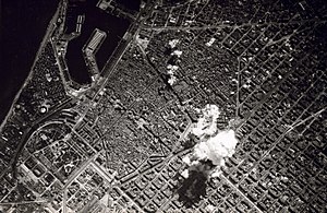
Bombing of Barcelona
1938 bombing during the Spanish civil war
Distance: Approx. 8 meters
Latitude and longitude: 41.387,2.17
The bombing of Barcelona was a series of airstrikes led by Fascist Italy and Nazi Germany supporting the Franco-led Nationalist rebel army, which took place from 16 to 18 March 1938, during the Spanish Civil War. Up to 1,300 people were killed and at least 2,000 were wounded.

Santa Anna de Barcelona
Historic site in Catalonia, Spain
Distance: Approx. 163 meters
Latitude and longitude: 41.38591,2.171409
The Church of Santa Anna (Catalan: Església de Santa Anna, Spanish: Iglesia de Santa Ana) is a church located in Barcelona, Catalonia, Spain. It was declared Bien de Interés Cultural in 1881.
Weather in this IP's area
few clouds
15 Celsius
14 Celsius
13 Celsius
16 Celsius
1018 hPa
75 %
1018 hPa
1014 hPa
10000 meters
2.57 m/s
320 degree
20 %
08:07:45
19:04:22