Country:
 USA
USARegion:
City:
Latitude and Longitude:
Time Zone:
Postal Code:
IP information under different IP Channel
ip-api
Country
Region
City
ASN
Time Zone
ISP
Blacklist
Proxy
Latitude
Longitude
Postal
Route
IPinfo
Country
Region
City
ASN
Time Zone
ISP
Blacklist
Proxy
Latitude
Longitude
Postal
Route
MaxMind
Country
Region
City
ASN
Time Zone
ISP
Blacklist
Proxy
Latitude
Longitude
Postal
Route
Luminati
Country
USRegion
ca
City
malibu
ASN
Time Zone
America/Los_Angeles
ISP
PEPPERDINE
Latitude
Longitude
Postal
db-ip
Country
Region
City
ASN
Time Zone
ISP
Blacklist
Proxy
Latitude
Longitude
Postal
Route
ipdata
Country
Region
City
ASN
Time Zone
ISP
Blacklist
Proxy
Latitude
Longitude
Postal
Route
Popular places and events near this IP address

Malibu High School
Public school in Malibu, California, United States
Distance: Approx. 2536 meters
Latitude and longitude: 34.02442,-118.82696
Malibu High School (MHS) is a public high school in Malibu, California. The school is one of three high schools in the Santa Monica–Malibu Unified School District and serves students in the city of Malibu and surrounding communities.

California's 33rd congressional district
U.S. House district for California
Distance: Approx. 5375 meters
Latitude and longitude: 34.04694444,-118.78333333
California's 33rd congressional district is a congressional district in the U.S. state of California. The district is currently represented by Democrat Pete Aguilar. From January 3, 2023, following the 2020 redistricting cycle, the district centered on San Bernardino.
Point Dume
Coastal landform in California, United States
Distance: Approx. 696 meters
Latitude and longitude: 34.00087222,-118.80683889
Point Dume is a promontory on the coast of Malibu, California that juts out into the Pacific Ocean. The point, a long bluff, forms the northern end of the Santa Monica Bay. Point Dume Natural Area affords a vista of the Palos Verdes Peninsula and Santa Catalina Island.
Ramirez Canyon Park
Park in Los Angeles County, California, United States
Distance: Approx. 4092 meters
Latitude and longitude: 34.03861111,-118.79416667
Ramirez Canyon Park is a public park owned by the state of California. Barbra Streisand donated this estate to the state-run Santa Monica Mountains Conservancy in 1993. The estate has 22.5 acres (9.1 ha) of lush vegetation, streams, and bridges.

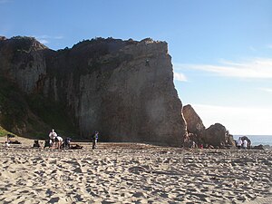
Zuma Beach
Public seashore, Los Angeles County, California
Distance: Approx. 2465 meters
Latitude and longitude: 34.021,-118.831
Zuma Beach is a county beach at 30000 Pacific Coast Highway (PCH) in Malibu, California. One of the largest and most popular beaches in Los Angeles County, California, it is known for its long, wide sands and excellent surf. It consistently ranks among the healthiest beaches for clean water conditions in Los Angeles County.
Malibu-Newton Canyon AVA
Distance: Approx. 3587 meters
Latitude and longitude: 34.0345,-118.7965
The Malibu-Newton Canyon Valley AVA is an American Viticultural Area in Los Angeles County, California. The boundaries of the AVA include Newton Canyon, located about 4 miles (6 km) from the Pacific Ocean within the city limits of Malibu. George Rosenthal planted the first vineyards planted in the area since Prohibition in 1987, and was successful in his petition for the creation of the AVA in 1996.
Malibu Vista, California
Unincorporated community in California, United States
Distance: Approx. 5917 meters
Latitude and longitude: 34.04777778,-118.77416667
Malibu Vista is an unincorporated community in Los Angeles County, California, United States. Malibu Vista is located in the Santa Monica Mountains 1.6 miles (2.6 km) north of the Pacific Ocean at Malibu. Malibu Vista, one of a handful of residential tracts in the Malibu–Topanga hills, is the one relatively closest to Point Dume, and is in the same canyon as Malibu Mar Vista (but closer to the beach).
Passages Malibu
For-profit addiction treatment facility
Distance: Approx. 4782 meters
Latitude and longitude: 34.02694444,-118.76777778
Passages Malibu Addiction Treatment Center, known as Passages Malibu, is a for-profit addiction treatment facility located in Malibu, California and founded by Pax and Chris Prentiss in 2001. Passages Ventura opened in 2009 in Port Hueneme, California.
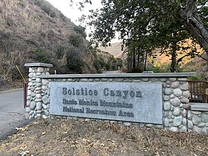
Solstice Canyon
Park in Malibu, California, United States
Distance: Approx. 6524 meters
Latitude and longitude: 34.0391,-118.7548
Solstice Canyon is a park within the Santa Monica Mountains National Recreation Area in Malibu, California. Located off Corral Canyon Road from Pacific Coast Highway, the canyon runs north-to-south about a mile east of Point Dume. Solstice Canyon opened on June 20, 1988 and was created out of land owned by Fred and Florence Roberts.
Cliffside Malibu
Hospital in California, United States
Distance: Approx. 3649 meters
Latitude and longitude: 34.034714,-118.829351
Cliffside Malibu is a drug rehabilitation center in Malibu, California, United States. It is notable for being frequently used by celebrities including Lindsay Lohan and Ty Lawson when they have been sentenced to rehabilitation. Kelly Stephenson has been the CEO of Cliffside Malibu since July 2018.
Montgomery Arts House for Music and Architecture
Distance: Approx. 1816 meters
Latitude and longitude: 34.020721,-118.818069
Montgomery Arts House for Music and Architecture is an Eric Lloyd Wright-designed house in Malibu, California completed in 2001.
Zuma and Trancas Canyons
Distance: Approx. 3892 meters
Latitude and longitude: 34.04,-118.815
Zuma and Trancas Canyons are an area of Federal parkland to the west of Malibu, California. It lies within the Santa Monica Mountains National Recreation Area and is the largest piece of Federal parkland in the NRA. Zuma Canyon contains a number of trails for hikers, of varying severity, and is the home of a range of wildlife, including the wrentit, known as the "Voice of the Chaparral". The park's eastern boundary is marked by Kanan Dume Road (county route N-9) and the north end of the parkland is crossed by the Backbone Trail, a 67-mile pathway through the Santa Monica Mountains.The name zuma is derived from a Chumash word meaning "abundance".
Weather in this IP's area
clear sky
16 Celsius
16 Celsius
14 Celsius
18 Celsius
1011 hPa
90 %
1011 hPa
1011 hPa
10000 meters
2.26 m/s
2.26 m/s
305 degree
06:41:40
18:56:05