Country:
Region:
City:
Latitude and Longitude:
Time Zone:
Postal Code:
IP information under different IP Channel
ip-api
Country
Region
City
ASN
Time Zone
ISP
Blacklist
Proxy
Latitude
Longitude
Postal
Route
Luminati
Country
Region
ca
City
simivalley
ASN
Time Zone
America/Los_Angeles
ISP
PEPPERDINE
Latitude
Longitude
Postal
IPinfo
Country
Region
City
ASN
Time Zone
ISP
Blacklist
Proxy
Latitude
Longitude
Postal
Route
db-ip
Country
Region
City
ASN
Time Zone
ISP
Blacklist
Proxy
Latitude
Longitude
Postal
Route
ipdata
Country
Region
City
ASN
Time Zone
ISP
Blacklist
Proxy
Latitude
Longitude
Postal
Route
Popular places and events near this IP address

Malibu, California
City in California, United States
Distance: Approx. 3842 meters
Latitude and longitude: 34.035,-118.695
Malibu ( MAL-ih-boo) is a beach city in the Santa Monica Mountains region of Los Angeles County, California, about 30 miles (48 km) west of Downtown Los Angeles. It is known for its Mediterranean climate, its strip of beaches stretching 21 miles (34 km) along the Pacific Ocean coast, and for its longtime status as the home of numerous affluent Hollywood celebrities and executives. Although a high proportion of its residents are entertainment industry figures with multi-million dollar mansions, Malibu also features several middle- and upper-middle-class neighborhoods.
Pepperdine University
Christian university in Los Angeles County, California
Distance: Approx. 2879 meters
Latitude and longitude: 34.03868333,-118.70758056
Pepperdine University () is a private Christian research university affiliated with the Churches of Christ with its main campus in Los Angeles County, California. Pepperdine's main campus consists of 830 acres (340 ha) overlooking the Pacific Ocean and the Pacific Coast Highway near Malibu, California. Founded by entrepreneur George Pepperdine in South Los Angeles in 1937, the school expanded to Malibu in 1972.

Firestone Fieldhouse
Arena in Malibu, California, United States
Distance: Approx. 2705 meters
Latitude and longitude: 34.038571,-118.709625
Firestone Fieldhouse is a multi-purpose arena in Malibu, California, on the campus of Pepperdine University. It was built in 1973 as the home to the Pepperdine Waves basketball and volleyball teams, who still play at the Fieldhouse today. It seats 3,104 for sporting events and up to 5,000 for concerts, graduation ceremonies, and lectures.

Eddy D. Field Stadium
Baseball stadium in Malibu, California, US
Distance: Approx. 2687 meters
Latitude and longitude: 34.040272,-118.711042
Eddy D. Field Stadium is home of the Pepperdine University Waves' baseball team located in Malibu, California. It was originally built in 1973, but underwent renovations in 1980 and 1999. It now holds up to 2,000 spectators, all box seats.
Pepperdine University School of Law
Law school in Malibu, California, US
Distance: Approx. 3054 meters
Latitude and longitude: 34.04399,-118.70932
The Pepperdine University Rick J. Caruso School of Law (formerly Pepperdine University School of Law) is the law school of Pepperdine University, a private research university in Los Angeles County, California. The school offers the Juris Doctor (JD), and various Masters of Laws (LLM) options in Dispute Resolution, International Commercial Arbitration, United States Law, and Entertainment, Media, and Sports Law. The school also offers joint degrees with its JD and Master of Dispute Resolution (MDR) in partnership with other Pepperdine University graduate schools.

Pepperdine University School of Public Policy
Public policy school of Pepperdine University
Distance: Approx. 3077 meters
Latitude and longitude: 34.0348,-118.7035
The Pepperdine University School of Public Policy (SPP) is a Master of Public Policy (MPP) degree program, located in Malibu, California with summer classes offered in Washington, D.C. It is one of four graduate schools at Pepperdine University. The MPP is customized with specializations in Applied Economic Policy, American Policy and Politics, International Relations and National Security, State and Local Policy, and Public Policy Dispute Resolution. The Master of Public Policy requires 50 units of coursework with four 3- or 4-unit courses each semester for two academic years (four semesters).

Raleigh Runnels Memorial Pool
Distance: Approx. 2673 meters
Latitude and longitude: 34.03886,-118.7102
The Raleigh Runnels Memorial Pool is an aquatics venue located on the campus of Pepperdine University in Malibu, California. The pool was constructed in 1975 and dedicated the following year to Raleigh Neal Runnels, the son of Pepperdine Chancellor Dr. Charles Runnels, who died of cancer at 17.
Passages Malibu
For-profit addiction treatment facility
Distance: Approx. 2969 meters
Latitude and longitude: 34.02694444,-118.76777778
Passages Malibu Addiction Treatment Center, known as Passages Malibu, is a for-profit addiction treatment facility located in Malibu, California and founded by Pax and Chris Prentiss in 2001. Passages Ventura opened in 2009 in Port Hueneme, California.

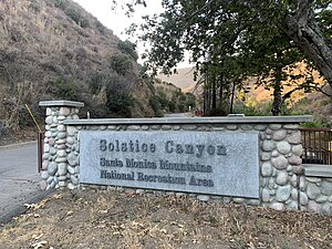
Solstice Canyon
Park in Malibu, California, United States
Distance: Approx. 2205 meters
Latitude and longitude: 34.0391,-118.7548
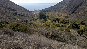
Solstice Canyon is a park within the Santa Monica Mountains National Recreation Area in Malibu, California. Located off Corral Canyon Road from Pacific Coast Highway, the canyon runs north-to-south about a mile east of Point Dume. Solstice Canyon opened on June 20, 1988 and was created out of land owned by Fred and Florence Roberts.

Corral Canyon
Valley in California, U.S.
Distance: Approx. 830 meters
Latitude and longitude: 34.03472222,-118.73472222
The Corral Canyon is a valley in Los Angeles County, California, United States. Located in the Santa Monica Mountains, it slopes down to the striking and diverse terrain of the Malibu coast. Corral Canyon State Park protects the southern portion of the valley and is managed and operated by the Mountains Recreation and Conservation Authority in partnership with the Santa Monica Mountains Conservancy.

Alumni Park (Pepperdine)
Distance: Approx. 2879 meters
Latitude and longitude: 34.03868333,-118.70758056
Alumni Park, is a private park owned by Pepperdine University in Malibu, California. The park is a 30 acre expanse of trails, lawns, hills, ponds and coral trees. The 40,000 square feet ponds are considered open reservoirs of reclaimed water.

El Nido, Los Angeles County, California
Unincorporated community in California, United States
Distance: Approx. 1845 meters
Latitude and longitude: 34.04361111,-118.73916667
El Nido (Spanish for "The Nest") is a residential neighborhood in Corral Canyon in unincorporated Los Angeles County, California, United States. The community, originally developed in the 1920s, is in the Santa Monica Mountains along the northern border of Malibu. There are two developments in Corral Canyon, El Nido is the lower of the two.
Weather in this IP's area
scattered clouds
15 Celsius
13 Celsius
12 Celsius
18 Celsius
1014 hPa
22 %
1014 hPa
1014 hPa
10000 meters
1.51 m/s
1.49 m/s
52 degree
42 %
06:22:28
16:55:17
