137.119.141.26 - IP Lookup: Free IP Address Lookup, Postal Code Lookup, IP Location Lookup, IP ASN, Public IP
Country:
Region:
City:
Location:
Time Zone:
Postal Code:
ISP:
ASN:
language:
User-Agent:
Proxy IP:
Blacklist:
IP information under different IP Channel
ip-api
Country
Region
City
ASN
Time Zone
ISP
Blacklist
Proxy
Latitude
Longitude
Postal
Route
db-ip
Country
Region
City
ASN
Time Zone
ISP
Blacklist
Proxy
Latitude
Longitude
Postal
Route
IPinfo
Country
Region
City
ASN
Time Zone
ISP
Blacklist
Proxy
Latitude
Longitude
Postal
Route
IP2Location
137.119.141.26Country
Region
tennessee
City
murfreesboro
Time Zone
America/Chicago
ISP
Language
User-Agent
Latitude
Longitude
Postal
ipdata
Country
Region
City
ASN
Time Zone
ISP
Blacklist
Proxy
Latitude
Longitude
Postal
Route
Popular places and events near this IP address

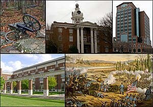
Murfreesboro, Tennessee
City in Tennessee, United States
Distance: Approx. 167 meters
Latitude and longitude: 35.84611111,-86.39194444
Murfreesboro is a city in, and county seat of, Rutherford County, Tennessee, United States. The population was 165,430 according to the 2023 census, up from 108,755 residents certified in 2010. Murfreesboro is located in the Nashville metropolitan area of Middle Tennessee, 34 miles (55 km) southeast of downtown Nashville.
First Battle of Murfreesboro
1862 battle of the American Civil War
Distance: Approx. 297 meters
Latitude and longitude: 35.847,-86.393
The First Battle of Murfreesboro was fought on July 13, 1862, in Rutherford County, Tennessee, as part of the American Civil War. Troops under Confederate cavalry commander Brig. Gen.
WETV-CD
TV station in Murfreesboro, Tennessee
Distance: Approx. 564 meters
Latitude and longitude: 35.84055556,-86.39083333
WETV-CD (channel 11) was a low-power, Class A independent television station in Murfreesboro, Tennessee, United States. Owned by The Rutherford Group, it was sister to radio station WGNS (1450 AM).

WGNS
Radio station in Murfreesboro, Tennessee
Distance: Approx. 564 meters
Latitude and longitude: 35.84055556,-86.39083333
WGNS (1450 AM) is a radio station based in Murfreesboro, Tennessee, United States. The call letters are an acronym representing the phrase, "Good Neighbor Station". The station covers Murfreesboro, Tennessee proper as well as the surrounding counties.
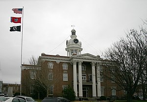
Rutherford County Courthouse (Tennessee)
United States historic place
Distance: Approx. 167 meters
Latitude and longitude: 35.84611111,-86.39194444
The Rutherford County Courthouse in Murfreesboro, Tennessee, is a Classical Revival building from 1859. It was listed on the National Register of Historic Places in 1973.
Allen Chapel A.M.E. Church (Murfreesboro, Tennessee)
Historic church in Tennessee, United States
Distance: Approx. 329 meters
Latitude and longitude: 35.84388889,-86.38722222
The Allen Chapel A.M.E. Church in Murfreesboro, Tennessee is a historic African Methodist Episcopal church at 224 S. Maney Avenue. It was built in 1889 and added to the National Register in 1995. It is a one-story brick building on a brick foundation.

First Presbyterian Church (Murfreesboro, Tennessee)
Historic church in Tennessee, United States
Distance: Approx. 168 meters
Latitude and longitude: 35.84706389,-86.38976944
Murfree Springs Presbyterian Church was founded in 1812 in a log cabin. In 1818 it changed its name to First Presbyterian Church and in 1820 moved to a brick meeting house on East Vine Street. First Presbyterian Church currently is a historic church at 210 N. Spring Street in Murfreesboro, Tennessee.

Bradley Academy Museum
United States historic place
Distance: Approx. 386 meters
Latitude and longitude: 35.84223889,-86.38916944
Bradley Academy Museum is a historic school building in Murfreesboro, Tennessee, that now serves as a museum and community center.

Gen. Joseph B. Palmer House
Historic house in Tennessee, United States
Distance: Approx. 459 meters
Latitude and longitude: 35.845025,-86.38516667
The Gen. Joseph B. Palmer House is a historic house in Murfreesboro, Tennessee, U.S.. It was built in 1867-1869 for Joseph B. Palmer, who served as a general in the Confederate States Army during the American Civil War of 1861–1865.

Collier-Lane-Crichlow House
Historic house in Tennessee, United States
Distance: Approx. 490 meters
Latitude and longitude: 35.84994444,-86.38936111
The Collier-Lane-Crichlow House was a historic house in Murfreesboro, Tennessee, United States. It was built circa 1850 for architect Sterling P. Jones, who designed in the Federal, Georgian and Greek Revival architectural styles. It was purchased by brothers Jessie A. Collier and Newton C. Collier in 1858.

Childress-Ray House
Historic house in Tennessee, United States
Distance: Approx. 260 meters
Latitude and longitude: 35.84766944,-86.38886944
The Childress-Ray House is a historic house in Murfreesboro, Tennessee, United States. It was built in 1847. In 1874, it was purchased by John Childress, the brother of U.S. First Lady Sarah Childress Polk, brother-in-law of U.S. President James K. Polk, and the father-in-law of Tennessee Governor John C. Brown.

Landsberger-Gerhardt House
Historic house in Tennessee, United States
Distance: Approx. 507 meters
Latitude and longitude: 35.85013889,-86.38973056
The Landsberger-Gerhardt House, also known as the Fite-Anderson House, is a historic house in Murfreesboro, Tennessee, U.S.. It was built in the Antebellum era for a merchant. It is listed on the National register of Historic Places.
Weather in this IP's area
clear sky
-7 Celsius
-7 Celsius
-9 Celsius
-6 Celsius
1031 hPa
90 %
1031 hPa
1003 hPa
10000 meters

