136.239.109.135 - IP Lookup: Free IP Address Lookup, Postal Code Lookup, IP Location Lookup, IP ASN, Public IP
Country:
Region:
City:
Location:
Time Zone:
Postal Code:
IP information under different IP Channel
ip-api
Country
Region
City
ASN
Time Zone
ISP
Blacklist
Proxy
Latitude
Longitude
Postal
Route
Luminati
Country
Region
al
City
vestaviahills
ASN
Time Zone
America/Chicago
ISP
DECATURTELCO
Latitude
Longitude
Postal
IPinfo
Country
Region
City
ASN
Time Zone
ISP
Blacklist
Proxy
Latitude
Longitude
Postal
Route
IP2Location
136.239.109.135Country
Region
alabama
City
vestavia hills
Time Zone
America/Chicago
ISP
Language
User-Agent
Latitude
Longitude
Postal
db-ip
Country
Region
City
ASN
Time Zone
ISP
Blacklist
Proxy
Latitude
Longitude
Postal
Route
ipdata
Country
Region
City
ASN
Time Zone
ISP
Blacklist
Proxy
Latitude
Longitude
Postal
Route
Popular places and events near this IP address

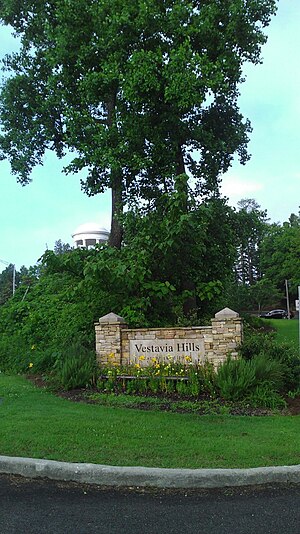
Vestavia Hills, Alabama
City in Alabama, United States
Distance: Approx. 1928 meters
Latitude and longitude: 33.43305556,-86.77888889
Vestavia Hills, colloquially known simply as Vestavia, is a city in Jefferson and Shelby counties in the U.S. state of Alabama. It is a suburb of Birmingham and it is made up of Vestavia, Liberty Park, and Cahaba Heights. The population was 39,102 at the 2020 census.
Samford University
Christian university in Homewood, Alabama, US
Distance: Approx. 1885 meters
Latitude and longitude: 33.4649,-86.7937
Samford University is a private Christian university in Homewood, Alabama, United States. It was founded by Baptists in 1841 as Howard College and located until 1887 in Marion, Alabama. In the fall of 2024, the university enrolled 6,101 students from 45 states, 1 U.S. territory, and 16 countries.
Seibert Hall
Distance: Approx. 1893 meters
Latitude and longitude: 33.4643,-86.7959
Seibert Hall is a 4,240-seat multi-purpose arena in Homewood, Alabama. It was built in 1961. It was home to the Samford University Bulldogs basketball team.

Pete Hanna Stadium
Stadium in Homewood, Alabama, USA
Distance: Approx. 1760 meters
Latitude and longitude: 33.463236,-86.795254
Pete Hanna Stadium (formerly Seibert Stadium) is a 6,700-seat multi-purpose stadium in Homewood, Alabama. It is home to the Samford University Bulldogs college football team. The facility opened in 1958 and is named for F. Page Seibert, who in 1961, donated money for the completion of the stadium.

McWhorter School of Pharmacy
College at Samford University in Alabama, USA
Distance: Approx. 1790 meters
Latitude and longitude: 33.46463611,-86.79037222
The McWhorter School of Pharmacy is the pharmacy school of Samford University. It was established in 1927, closed in 1929 and reopened in 1932.
Beeson Divinity School
Distance: Approx. 1810 meters
Latitude and longitude: 33.4642499,-86.79351
Beeson Divinity School of Samford University is an in-person, interdenominational, evangelical divinity school located in Birmingham, Alabama, United States. The current dean is Douglas A. Sweeney. The school offers several degrees Master of Divinity, Master of Arts in Christian Counseling, Master of Arts in Theological Studies, a Master of Theology and the Doctor of Philosophy in Theology for the Church.
Pete Hanna Center
Distance: Approx. 1898 meters
Latitude and longitude: 33.4638,-86.7973
The Pete Hanna Center is the building housing the 4,974-seat Thomas E. and Marla H. Corts Arena on the campus of Samford University in Homewood (a suburb of Birmingham), in the U.S. state of Alabama. It is home to the Samford Bulldogs basketball and volleyball teams, which previously played in Seibert Hall. The facility opened in October 2007 and is named for Pete Hanna, the owner, president and chief executive officer of Hanna Steel Corporation.
Homewood High School
High school in Homewood, Alabama, United States
Distance: Approx. 1370 meters
Latitude and longitude: 33.46083333,-86.79027778
Homewood High School (HHS) is a public high school, serving grades 9–12, in the Homewood, Alabama suburb of Birmingham. It is the only high school in the Homewood City School System. The principal is Joel Henneke.
Andrew Westmoreland
American academic administrator
Distance: Approx. 1935 meters
Latitude and longitude: 33.4657,-86.79214
Andrew Westmoreland is a retired American academic administrator. He was the 18th President of Samford University in Birmingham, Alabama since 2006 to 2021. From 1998 to 2006, he was the president of Ouachita Baptist University in Arkadelphia, Arkansas.
Joe Lee Griffin Stadium
Baseball venue in Birmingham, Alabama
Distance: Approx. 1822 meters
Latitude and longitude: 33.463393,-86.79645
Joe Lee Griffin Stadium is a baseball venue located in Birmingham, Alabama, USA. It is home to the Samford Bulldogs college baseball team of the Division I Southern Conference. It has a capacity of 1,000 spectators. The facility was extensively renovated in 2000.
Thomas E. Corts
American university president
Distance: Approx. 1935 meters
Latitude and longitude: 33.4657,-86.79214
Thomas Edward Corts (1941–2009) was an American university president. He served as President of Wingate College in North Carolina from 1974 to 1983, and the 17th President of Samford University in Birmingham, Alabama from 1983 to 2006.
Edgewood Lake (Alabama)
Former lake in Homewood, Alabama
Distance: Approx. 1640 meters
Latitude and longitude: 33.45611111,-86.80305556
Edgewood Lake was located in Homewood, Alabama, from 1913 until the 1940s when the lake was drained. The lake was formed by damming Shades Creek near Green Springs Highway. Developed as part of the town of Edgewood, the 117-acre (47 ha) lake was the center of a planned auto racing track that was never completed.
Weather in this IP's area
scattered clouds
0 Celsius
-2 Celsius
-1 Celsius
2 Celsius
1019 hPa
82 %
1019 hPa
994 hPa
10000 meters
1.79 m/s
2.53 m/s
326 degree
47 %
