Country:
 Norway
Region:
City:
Latitude and Longitude:
Time Zone:
Postal Code:
IP information under different IP Channel
ip-api
Country
Region
City
ASN
Time Zone
ISP
Blacklist
Proxy
Latitude
Longitude
Postal
Route
IPinfo
Country
Region
City
ASN
Time Zone
ISP
Blacklist
Proxy
Latitude
Longitude
Postal
Route
MaxMind
Country
Region
City
ASN
Time Zone
ISP
Blacklist
Proxy
Latitude
Longitude
Postal
Route
Luminati
Country
 US
USASN
Time Zone
America/Chicago
ISP
Telia Norge AS
Latitude
Longitude
Postal
db-ip
Country
Region
City
ASN
Time Zone
ISP
Blacklist
Proxy
Latitude
Longitude
Postal
Route
ipdata
Country
Region
City
ASN
Time Zone
ISP
Blacklist
Proxy
Latitude
Longitude
Postal
Route
Popular places and events near this IP address

Gamle Oslo
Borough in Norway
Distance: Approx. 433 meters
Latitude and longitude: 59.9129,10.7819
Gamle Oslo is a borough of the city of Oslo, Norway. The name means "Old Oslo", and the district contains Old Town. The borough has several landmarks and large parks, including the Edvard Munch Museum, the Botanical Gardens and a medieval park.
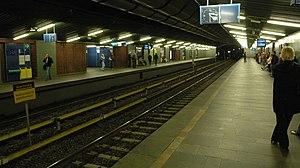
Tøyen metro station
Oslo metro station
Distance: Approx. 308 meters
Latitude and longitude: 59.915,10.77611111
Tøyen is a rapid transit station located in the Common Tunnel of Oslo Metro in Norway. Located in the borough of Gamle Oslo, it was also called "Tøyen-Munchmuseet" due to its proximity to the former art museum. The sign on platform 4 formerly said Munchmuseet underneath the station name, but it has been covered over with blue tape.
Nonneseter Abbey, Oslo
Benedictine nunnery located in Oslo, Norway
Distance: Approx. 544 meters
Latitude and longitude: 59.90861111,10.76805556
Nonneseter Abbey, Oslo (Nonneseter kloster i Oslo), was a Benedictine convent located in Oslo, Norway, active between the 12th and 16th centuries.

Kampen, Norway
Distance: Approx. 324 meters
Latitude and longitude: 59.9137,10.7794
Kampen is a neighborhood in Oslo, Norway. It is located Gamle Oslo borough, between Tøyen, Hasle, Vålerenga and Galgeberg.
Botsfengselet
Prison in Oslo, Norway
Distance: Approx. 358 meters
Latitude and longitude: 59.90944444,10.77166667
Botsfengselet is a former national prison for long-term prisoners in Oslo, Norway. Its location is at the former Åkebergløkka, Grønlandsleiret 41. The prison was designed by architect Heinrich Ernst Schirmer.

Åkebergveien
Distance: Approx. 240 meters
Latitude and longitude: 59.91024444,10.77421944
Åkebergveien is a street in Oslo, Norway. The street is named after the former farm Åkeberg. Åkebergveien 11 formerly belonged to the brewery Ytteborgs Aktiebryggeri.

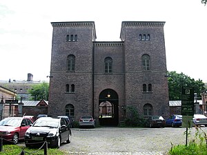
Oslo Prison
Prison in Norway
Distance: Approx. 333 meters
Latitude and longitude: 59.90944444,10.77333333
Oslo Prison (Norwegian: Oslo fengsel) is the district prison of Oslo, Norway. It is the largest prison in Norway, with a capacity of around 350 detainees. The prison was called Oslo kretsfengsel until 2001.

Grønland Church
Church in Oslo, Norway
Distance: Approx. 394 meters
Latitude and longitude: 59.91107,10.767664
Grønland Church (Grønland kirke) is a church located in the neighbourhood of Grønland in the borough of Gamle Oslo in Oslo, Norway. Grønland Church congregation was formed in 1861. Grønland Church was consecrated on March 3, 1869, by Bishop Jens Lauritz Arup.

St. Hallvard's Church and Monastery
Church in Oslo, Norway
Distance: Approx. 287 meters
Latitude and longitude: 59.91265278,10.76908889
St. Hallvard's Church and Monastery (Norwegian: St. Hallvard kirke og kloster) on Enerhaugen in Oslo, Norway, not far from the former medieval St.

Enerhaugen
Area of Oslo, Norway
Distance: Approx. 278 meters
Latitude and longitude: 59.91293389,10.769327
Enerhaugen is today a neighborhood in Oslo, Norway which among others includes six apartment buildings on Tøyen in the borough of Gamle Oslo, located north of the neighborhood of Grønland. The site is located on a hill just south of Tøyen manor, and was largely undeveloped in the first half of the 1800s, where it then became a sort of suburb of Oslo. The streets of today's Enerhaugen is Sørligata, Enerhaugggata and Smedgata.

Kampen Church, Oslo
Church in Oslo, Norway
Distance: Approx. 437 meters
Latitude and longitude: 59.91195,10.78197111
Kampen Church is a church in the neighborhood of Kampen in Oslo, Norway. The church was consecrated 29 November 1882. After a fire in Kampen in 1878, the plans for the reconstruction of the neighborhood included a new church.

Klosterenga
Park in Oslo municipality, Norway
Distance: Approx. 458 meters
Latitude and longitude: 59.908351,10.775614
Klosterenga or Klosterenga park is a park in Oslo, located in the transition between Old Town and Grønland. The park route extends up to Galgeberg. It was made as part of a housing project.
Weather in this IP's area
overcast clouds
13 Celsius
12 Celsius
11 Celsius
14 Celsius
1017 hPa
96 %
1017 hPa
1013 hPa
10000 meters
0.96 m/s
2.96 m/s
141 degree
100 %
08:06:23
17:56:55