136.235.243.2 - IP Lookup: Free IP Address Lookup, Postal Code Lookup, IP Location Lookup, IP ASN, Public IP
Country:
 USA
USARegion:
City:
Location:
Time Zone:
Postal Code:
ISP:
ASN:
language:
User-Agent:
Proxy IP:
Blacklist:
IP information under different IP Channel
ip-api
Country
Region
City
ASN
Time Zone
ISP
Blacklist
Proxy
Latitude
Longitude
Postal
Route
db-ip
Country
Region
City
ASN
Time Zone
ISP
Blacklist
Proxy
Latitude
Longitude
Postal
Route
IPinfo
Country
Region
City
ASN
Time Zone
ISP
Blacklist
Proxy
Latitude
Longitude
Postal
Route
IP2Location
136.235.243.2Country
usRegion
california
City
carmichael
Time Zone
America/Los_Angeles
ISP
Language
User-Agent
Latitude
Longitude
Postal
ipdata
Country
Region
City
ASN
Time Zone
ISP
Blacklist
Proxy
Latitude
Longitude
Postal
Route
Popular places and events near this IP address
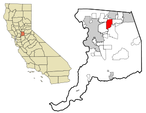
Carmichael, California
Census-designated place in California, United States
Distance: Approx. 1378 meters
Latitude and longitude: 38.63944444,-121.32138889
Carmichael is a census-designated place (CDP) in Sacramento County, California, United States. It is an unincorporated suburb in the Greater Sacramento metropolitan area. The population was 79,793 at the 2020 census.

American River College
Community college in Sacramento, California
Distance: Approx. 2825 meters
Latitude and longitude: 38.64946,-121.34623
American River College (ARC) is a public community college in unincorporated Sacramento, California. It is part of the California Community Colleges System.

Jensen Botanical Gardens
Botanical garden in California
Distance: Approx. 1389 meters
Latitude and longitude: 38.6394,-121.321
The Charles C. Jensen Botanical Gardens are botanical gardens located at 8520 Fair Oaks Boulevard, Carmichael, California. They are open during the daylight hours without charge. The gardens exhibit a variety of flora including camellias, dogwoods, azaleas, and rhododendrons.
Del Campo High School
Public high school near Sacramento, California
Distance: Approx. 3248 meters
Latitude and longitude: 38.65451111,-121.31188889
Del Campo High School, is a public high school in Fair Oaks, California. It is a member of the San Juan Unified School District and serves western Fair Oaks and eastern Carmichael.
Cordova High School (California)
Public high school in Rancho Cordova, California
Distance: Approx. 3579 meters
Latitude and longitude: 38.60055556,-121.3075
Cordova High School is a comprehensive public high school in Rancho Cordova, California. It is one of five high schools in Folsom Cordova Unified School District. The school opened in 1963 with the first graduating class in 1965.

American River Parkway
Distance: Approx. 2629 meters
Latitude and longitude: 38.62,-121.3
The American River Parkway is a 32-mile (51 km) urban regional recreation area that runs along the American River throughout Sacramento County, California, consisting of many smaller parks and boat launching points. It can be accessed by various exits off U.S. Route 50 in Sacramento County. Levees line the river to prevent flooding of developed areas.
Carmichael Park
Distance: Approx. 238 meters
Latitude and longitude: 38.6275,-121.33083333
Carmichael Park is a major 38-acre (150,000 m2) park in Carmichael, California, an unincorporated suburb of Sacramento, California. The park includes 5 ballfields, 6 tennis courts and a dog park. The Community Clubhouse, Veterans' Memorial Building, the Daniel Bishop Memorial Pavilion for the Performing Arts, and the Great Wall of Carmichael are all located within the park.
Epic Bible College
Private Bible college in Sacramento, California
Distance: Approx. 3527 meters
Latitude and longitude: 38.64516667,-121.36263889
Epic Bible College (formerly known as Trinity Life Bible College or TLBC) is a private Bible college in Sacramento, California.
Yalisumni, California
Distance: Approx. 3038 meters
Latitude and longitude: 38.6071,-121.3063
Yalisumni is a former Nisenan settlement in El Dorado County, California. It was located near Salmon Falls on the south side of the South Fork of the American River; its precise location is unknown. It was a source of workers for John Sutter's New Helvetia settlement, located in present-day Sacramento between Yalisumni and another Nisenan settlement, Pujuni.
KQPT-LP
Radio station in Sacramento, California
Distance: Approx. 421 meters
Latitude and longitude: 38.625375,-121.32522778
KQPT-LP was a low-power FM radio station broadcasting out of Sacramento, California and licensed to Sacramento Area Peace Action. It began broadcasting as KAKP-LP on August 27, 2017. Sacramento Area Peace Action surrendered KQPT-LP's license to the Federal Communications Commission on June 7, 2023, and it was cancelled the next day.
Effie Yeaw Nature Center
Nature center in Carmichael, California
Distance: Approx. 1891 meters
Latitude and longitude: 38.61748406,-121.31153141
Effie Yeaw Nature Center is a nature center inside Ancil Hoffman Park in the city of Carmichael, California. The Effie Yeaw Nature Center is part of the American River Parkway. The Effie Yeaw Nature Center is east of the city of Sacramento and has a replica of a Nisenan Tribe Village hut.

Casa de los Gobernadores
Building in Carmichael, California
Distance: Approx. 2565 meters
Latitude and longitude: 38.605925,-121.321256
The Casa de los Gobernadores (Spanish for "House of the Governors") is a mansion that was originally built to serve as the official residence of the governor of California, located in Carmichael, California, in Greater Sacramento. Today, it serves as a private residence.
Weather in this IP's area
clear sky
14 Celsius
13 Celsius
13 Celsius
15 Celsius
1021 hPa
61 %
1021 hPa
1018 hPa
10000 meters
2.57 m/s
260 degree