136.228.50.119 - IP Lookup: Free IP Address Lookup, Postal Code Lookup, IP Location Lookup, IP ASN, Public IP
Country:
 USA
USARegion:
City:
Location:
Time Zone:
Postal Code:
ISP:
ASN:
language:
User-Agent:
Proxy IP:
Blacklist:
IP information under different IP Channel
ip-api
Country
Region
City
ASN
Time Zone
ISP
Blacklist
Proxy
Latitude
Longitude
Postal
Route
db-ip
Country
Region
City
ASN
Time Zone
ISP
Blacklist
Proxy
Latitude
Longitude
Postal
Route
IPinfo
Country
Region
City
ASN
Time Zone
ISP
Blacklist
Proxy
Latitude
Longitude
Postal
Route
IP2Location
136.228.50.119Country
usRegion
michigan
City
charlevoix
Time Zone
America/Detroit
ISP
Language
User-Agent
Latitude
Longitude
Postal
ipdata
Country
Region
City
ASN
Time Zone
ISP
Blacklist
Proxy
Latitude
Longitude
Postal
Route
Popular places and events near this IP address
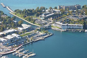
Charlevoix, Michigan
City in Michigan, United States
Distance: Approx. 4407 meters
Latitude and longitude: 45.31805556,-85.25833333
Charlevoix ( SHAR-lə-voy) is a city in the U.S. state of Michigan. It is the county seat of Charlevoix County. Part of Northern Michigan, Charlevoix is located on an isthmus between Lake Michigan and Lake Charlevoix, bisected by the short Pine River.

Marion Township, Charlevoix County, Michigan
Civil township in Michigan, United States
Distance: Approx. 3646 meters
Latitude and longitude: 45.25138889,-85.24638889
Marion Township is a civil township of Charlevoix County in the U.S. state of Michigan. The population was 1,657 at the 2020 census.

Belvedere Club
US home association
Distance: Approx. 1433 meters
Latitude and longitude: 45.29222222,-85.26888889
The Belvedere Club, located south of Charlevoix, Michigan is a summer home association of 91 cottages between Round Lake and Lake Charlevoix in Northern Michigan founded in 1878. Members are generally from upper class households and originate from the Midwest and South. Many families have been resorting to the club for generations.

Charlevoix South Pier Light Station
Lighthouse in Michigan, United States
Distance: Approx. 4567 meters
Latitude and longitude: 45.32024,-85.26491
The Charlevoix South Pier Light Station is located on Lake Michigan at the entrance to Lake Charlevoix in Charlevoix County in the U.S. state of Michigan at the end of the south pier/breakwater of the channel leading to Round Lake in the city of Charlevoix.

Charlevoix Municipal Airport
Airport
Distance: Approx. 2844 meters
Latitude and longitude: 45.30472222,-85.27527778
Charlevoix Municipal Airport (ICAO: KCVX, FAA LID: CVX) is a city-owned, public-use airport located one nautical mile (2 km) southwest of the central business district of Charlevoix, a city in Charlevoix County, Michigan, United States. It is mostly used for general aviation, but also offers passenger service to Beaver Island via Island Airways and Fresh Air Aviation. As per Federal Aviation Administration records, the airport had 17,854 passenger boardings (enplanements) in calendar year 2008, 15,427 enplanements in 2009, and 14,966 in 2010.

WMKT
Radio station in Charlevoix, Michigan
Distance: Approx. 1610 meters
Latitude and longitude: 45.27277778,-85.25222222
WMKT (1270 AM) is a radio station licensed to Charlevoix, Michigan, broadcasting a talk radio format. The station also broadcasts on two FM translators on W272CR 102.3 (formerly 92.1) and W277DY 103.3 and streams online. The station features local programming with local news and weather forecasts by Nick Rhudy every weekday during the 6 AM to Noon hours.

Castle Farms
United States historic place
Distance: Approx. 3217 meters
Latitude and longitude: 45.27861111,-85.22944444
Castle Farms is a special events facility located in Charlevoix, Michigan. It was constructed in 1918 by Albert Loeb, who was the Vice President of Sears, Roebuck and Company, and it was designed by Arthur Heun.

US 31–Island Lake Outlet Bridge
Bridge in Charlevoix, Michigan
Distance: Approx. 4493 meters
Latitude and longitude: 45.3189,-85.2587
The US 31–Island Lake Outlet Bridge is a double-leaf bascule bridge in downtown Charlevoix in the U.S. state of Michigan. The bridge carries U.S. Highway 31 (known locally as Bridge Street) across Island Lake Outlet (also known as the Pine River Channel) that ultimately connects Lake Charlevoix to Lake Michigan. It is the fifth bridge to cross the channel there with the first being a pedestrian-only structure that was built in the nineteenth century.

Charlevoix City Park Site
Archaeological site in Michigan, United States
Distance: Approx. 4256 meters
Latitude and longitude: 45.31666667,-85.25833333
The Charlevoix City Park Site is an archaeological site located between Bridge Street and Round Lake in Charlevoix, Michigan. It was listed on the National Register of Historic Places in 1972. The site is a Woodland period occupation, approximately AD 1000 - AD 1300.

Pine River Site
Archaeological site in Michigan, United States
Distance: Approx. 4518 meters
Latitude and longitude: 45.31944444,-85.26111111
The Pine River Site, also designated 20CX19, is an archaeological site located in Charlevoix, Michigan. It was listed on the National Register of Historic Places in 1972. This site is a multicomponent site, with evidence of occupation during the Archaic (c.

Charlevoix station (Michigan)
United States historic place
Distance: Approx. 4755 meters
Latitude and longitude: 45.3175,-85.24305556
The Chicago and West Michigan Railroad Charlevoix Station is a railroad depot located on Chicago Avenue in Charlevoix, Michigan. It was listed in the National Register of Historic Places in 1995.
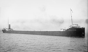
SS Amasa Stone
Distance: Approx. 4634 meters
Latitude and longitude: 45.31814,-85.292155
SS Amasa Stone was a 545-foot (166 m) Great Lakes freighter that was sunk as a breakwater in 1965, Charlevoix, Michigan. She was built for the Mesaba Steamship Company by the Detroit Shipbuilding Company of Wyandotte, Michigan. She was launched on March 25, 1905, as hull #158.
Weather in this IP's area
overcast clouds
-7 Celsius
-13 Celsius
-8 Celsius
-6 Celsius
1032 hPa
71 %
1032 hPa
1006 hPa
10000 meters
5.14 m/s
20 degree
100 %