Country:
 USA
USARegion:
City:
Latitude and Longitude:
Time Zone:
Postal Code:
IP information under different IP Channel
ip-api
Country
Region
City
ASN
Time Zone
ISP
Blacklist
Proxy
Latitude
Longitude
Postal
Route
IPinfo
Country
Region
City
ASN
Time Zone
ISP
Blacklist
Proxy
Latitude
Longitude
Postal
Route
MaxMind
Country
Region
City
ASN
Time Zone
ISP
Blacklist
Proxy
Latitude
Longitude
Postal
Route
Luminati
Country
USASN
Time Zone
America/Chicago
ISP
CENTURYLINK-US-LEGACY-QWEST
Latitude
Longitude
Postal
db-ip
Country
Region
City
ASN
Time Zone
ISP
Blacklist
Proxy
Latitude
Longitude
Postal
Route
ipdata
Country
Region
City
ASN
Time Zone
ISP
Blacklist
Proxy
Latitude
Longitude
Postal
Route
Popular places and events near this IP address
Charles Schwab Cup Championship
Golf tournament
Distance: Approx. 724 meters
Latitude and longitude: 33.4816,-112.0636
The Charles Schwab Cup Championship is the final event of the season on the U.S.-based PGA Tour Champions, the world's leading golf tour for male professionals aged 50 and above. Played in late October or early November each year, it is PGA Tour Champions' equivalent of the PGA Tour's Tour Championship, and was formerly known as the Senior Tour Championship. Like the Tour Championship, it has a small field (30 from 1990 through 2015, and 36 from 2016 forward) and no half-way cut.

Rhythm Room
Music venue in Phoenix, Arizona
Distance: Approx. 860 meters
Latitude and longitude: 33.494352,-112.059724
The Rhythm Room is a roots, blues, and concert club located in Phoenix, Arizona. It is the venue of nationally known acts on an almost nightly basis. In 2003 the club was named by the Phoenix New Times as the "Best Club for Blues" in its "Best of Phoenix" awards.

Osborn/Central Avenue station
Light rail station in Phoenix, Arizona
Distance: Approx. 826 meters
Latitude and longitude: 33.48666667,-112.07375
Osborn/Central Avenue (also known as Park Central) is a station on Valley Metro Rail in Phoenix, Arizona, United States. It is the seventh stop southbound and the twenty-second stop northbound on the initial 20-mile starter line.

Central Avenue Corridor
Employment and residential corridor in Phoenix
Distance: Approx. 849 meters
Latitude and longitude: 33.4926,-112.0723
The Central Avenue Corridor is a significant stretch of north–south Central Avenue in Phoenix, Arizona. Roughly bounded by Camelback Road to its north, and McDowell Road to its south, this is one of Phoenix's most vital and heavily trafficked stretches of roads. It is also one of the region's largest centers of employment, with nearly 60,000 people being employed within a three-mile (5 km) radius of this swath of Central Avenue.
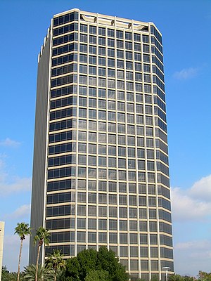
Phoenix Plaza
Mixed use office complex in Phoenix, Arizona
Distance: Approx. 1018 meters
Latitude and longitude: 33.481317,-112.072477
Phoenix Plaza is a mixed use office complex located in midtown Phoenix, Arizona. It was built between 1988 and 1990 at a cost of US$158 million. There is 1,600,000 square feet (150,000 m2) of office space plus 225 hotel rooms.

Phoenix Corporate Center
High-rise in Arizona, United States
Distance: Approx. 970 meters
Latitude and longitude: 33.4826,-112.0732
The Phoenix Corporate Tower (formerly known as First Federal Savings Building) is a 26-story high-rise office building in Phoenix, Arizona. It was built in 1965 and designed in the International Style. The tower was built two miles north of Downtown Phoenix in the Central Corridor.

3300 North Central Avenue
High-rise in Phoenix, Arizona
Distance: Approx. 878 meters
Latitude and longitude: 33.4871,-112.0744
3300 North Central Avenue (also known as 3300 Tower) is a high-rise located along Central Avenue in Uptown Phoenix, Arizona, United States. The tower rises 27 floors and 356 feet (109 m) in height. Designed by Skidmore, Owings and Merrill, 3300 North Central Avenue was built in 1980.
Great American Tower
High-rise in Phoenix, Arizona
Distance: Approx. 922 meters
Latitude and longitude: 33.4856,-112.0745
The 3200 N Central Building, formally known as Great American Tower, is a high-rise office building located along Central Avenue in the Uptown area of Phoenix, Arizona, United States. The tower rises 24 floors and 320 feet (98 m) in height. Owned by DPC Companies and Bridge Commercial Real Estate, 3200 N Central was built in 1985.

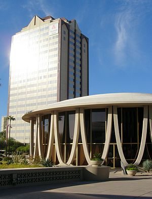
Phoenix Financial Center
High-rise business complex in Arizona
Distance: Approx. 748 meters
Latitude and longitude: 33.48805556,-112.07305556
The Phoenix Financial Center consists of a high-rise office building and two adjacent rotunda buildings located along Central Avenue in the Midtown district of Phoenix, Arizona, United States. They were built in 1963 by the Financial Corporation of Arizona. Ground was broken for the facility in September 1963, and the complex was dedicated for opening on September 28, 1964.
The Fry Bread House
Restaurant in Phoenix, Arizona
Distance: Approx. 841 meters
Latitude and longitude: 33.494613,-112.060628
The Fry Bread House is a restaurant in Phoenix, Arizona, serving fry bread, a Native American dish of dough fried in lard, Crisco, or oil, which the restaurant serves with various toppings or fillings. Exact recipes and ingredients vary but those typical of frybread are flour, salt, and lard, reflecting the commodities doled out on the reservations by the U.S. federal government. The Fry Bread House was opened in 1992 by Cecilia Miller, a member of the Tohono O'odham Nation of Native Americans.
Grand Central Tower (Phoenix)
High-rise in Arizona
Distance: Approx. 835 meters
Latitude and longitude: 33.4891,-112.0739
The Grand Central Tower (originally known as the Guaranty Bank Building) is a high-rise building in Phoenix, Arizona. It is an office building designed in international style and constructed between 1959 and 1960 for developer David H. Murdock. Upon completion, it became the city's tallest building, taking that 31 year distinction away from the Westward Ho which opened in 1929.
Phoenix Country Club
Arizona country club
Distance: Approx. 693 meters
Latitude and longitude: 33.482,-112.063
Phoenix Country Club is a country club in the southwestern United States, located in Phoenix, Arizona. The club was founded 124 years ago in 1899 and was moved to its current location in 1921. Golf Connoisseur Magazine rated Phoenix Country Club among top 100 Most Prestigious Private Clubs in America in 2006.
Weather in this IP's area
scattered clouds
31 Celsius
30 Celsius
29 Celsius
33 Celsius
1009 hPa
28 %
1009 hPa
972 hPa
10000 meters
3.6 m/s
80 degree
40 %
06:07:32
18:44:18