136.227.128.79 - IP Lookup: Free IP Address Lookup, Postal Code Lookup, IP Location Lookup, IP ASN, Public IP
Country:
Region:
City:
Location:
Time Zone:
Postal Code:
ISP:
ASN:
language:
User-Agent:
Proxy IP:
Blacklist:
IP information under different IP Channel
ip-api
Country
Region
City
ASN
Time Zone
ISP
Blacklist
Proxy
Latitude
Longitude
Postal
Route
db-ip
Country
Region
City
ASN
Time Zone
ISP
Blacklist
Proxy
Latitude
Longitude
Postal
Route
IPinfo
Country
Region
City
ASN
Time Zone
ISP
Blacklist
Proxy
Latitude
Longitude
Postal
Route
IP2Location
136.227.128.79Country
Region
ohio
City
springfield
Time Zone
America/New_York
ISP
Language
User-Agent
Latitude
Longitude
Postal
ipdata
Country
Region
City
ASN
Time Zone
ISP
Blacklist
Proxy
Latitude
Longitude
Postal
Route
Popular places and events near this IP address
Wittenberg University
Private university in Springfield, Ohio, U.S.
Distance: Approx. 3869 meters
Latitude and longitude: 39.935,-83.8125
Wittenberg University is a private liberal arts college in Springfield, Ohio. It has 1,326 full-time students drawn from 33 states and 9 foreign countries. Wittenberg University is associated with the Evangelical Lutheran Church in America.
WDHT
Radio station in Urbana, Ohio
Distance: Approx. 3253 meters
Latitude and longitude: 39.953,-83.869
WDHT (102.9 FM "Hot 102.9") is an urban-leaning rhythmic contemporary radio station in Urbana, Ohio serving the Dayton–Springfield area. WDHT is currently owned by Alpha Media, which also owns WING, WROU-FM, WCLI-FM and WGTZ. Its transmitter site on Miller Road in Springfield is shared with that of WULM, as this was previously the transmitting site of the former WBLY/WAZU. Its studios are in Kettering, Ohio.

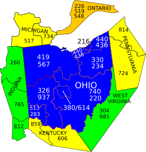
Area codes 937 and 326
Area codes for Dayton and part of southwestern Ohio, United States
Distance: Approx. 2552 meters
Latitude and longitude: 39.92230556,-83.8265
Area codes 937 and 326 are telephone area codes in the North American Numbering Plan (NANP) assigned to a numbering plan area (NPA) that encompasses much of the southwestern part of the U.S. state of Ohio, including Dayton and Springfield. Area code 937 was established in September 1996, in a split of area code 513. Area code 326 was added to the numbering plan area to form an overlay complex in March 2020.

Clark County Heritage Center
History Museum in Springfield, Ohio
Distance: Approx. 3881 meters
Latitude and longitude: 39.922819,-83.810779
The Clark County Heritage Center is a Romanesque architecture-style building in central Springfield, Ohio, United States. Originally built for the city's offices in 1890, it was replaced in 1979 with the current Springfield City Hall and is now the location of the Clark County Historical Society (founded in 1897), which includes a museum, research library and archives. The building has been listed on the National Register of Historic Places.
Upper Valley Mall
Shopping mall in Near Springfield, Ohio
Distance: Approx. 2609 meters
Latitude and longitude: 39.9488889,-83.8541667
Upper Valley Mall was a shopping mall located near Springfield, Ohio, northeast of Dayton. Built in 1971 by the Edward J. DeBartolo Corporation of Youngstown, the mall at closing had no anchor stores. The Upper Valley Mall was located west of Springfield, off US 68, in German Township, Clark County.

Tecumseh Building
United States historic place
Distance: Approx. 3799 meters
Latitude and longitude: 39.92355556,-83.81166667
The Tecumseh Building, also known as the Francis J. Drolla Building, is a historic building in downtown Springfield, Ohio, United States. Located at 34 West High Street, it was designed by J.A. Poss and W.E. Russ and is described as being an example of "Early Commercial" architecture. It was added to the National Register of Historic Places in 2000 for its architectural significance.

Masonic Temple (Springfield, Ohio)
United States historic place
Distance: Approx. 3659 meters
Latitude and longitude: 39.92333333,-83.81333333
The Masonic Temple is a historic structure in Springfield, Ohio, United States. Located along High Street in downtown Springfield, the temple was designed by Howard Dwight Smith and the firm of Miller & Reeves. Local Freemasons have met at the temple since construction was finished in January 1927.

St. John's Evangelical Lutheran Church (Springfield, Ohio)
Historic church in Ohio, United States
Distance: Approx. 3556 meters
Latitude and longitude: 39.92583333,-83.81444444
St. John's Evangelical Lutheran Church is a historic Lutheran church in downtown Springfield, Ohio, United States. Founded as a German-speaking parish in Springfield's early days, it grew rapidly during its first few decades, and its present large church building was constructed in the 1890s under the direction of one of Springfield's leading architects.

Pennsylvania House (Springfield, Ohio)
United States historic place
Distance: Approx. 1991 meters
Latitude and longitude: 39.92555556,-83.83277778
The Pennsylvania House is a historic inn and tavern in western Springfield, Ohio, United States. Built circa 1822, this three-story brick Federal structure lies along the original National Road and near the old road that connects Springfield with Dayton, Ohio. In the early years of the nineteenth century, the National and Dayton-Springfield Roads were major transportation arteries for those bound for the West and for Cincinnati respectively.
Sugar Grove, Clark County, Ohio
Unincorporated community in Ohio, U.S.
Distance: Approx. 477 meters
Latitude and longitude: 39.9258333,-83.8616667
Sugar Grove is an unincorporated community in Clark County, Ohio, US.
Durbin, Ohio
Unincorporated community in Ohio, U.S.
Distance: Approx. 3225 meters
Latitude and longitude: 39.91111111,-83.88888889
Durbin is an unincorporated community in Clark County, in the U.S. state of Ohio.
Limestone City, Ohio
Unincorporated community in Ohio, U.S.
Distance: Approx. 2315 meters
Latitude and longitude: 39.91194444,-83.87666667
Limestone City is an unincorporated community in Clark County, in the U.S. state of Ohio.
Weather in this IP's area
overcast clouds
-5 Celsius
-10 Celsius
-5 Celsius
-3 Celsius
1026 hPa
88 %
1026 hPa
986 hPa
8047 meters
3.6 m/s
320 degree
100 %