136.200.241.64 - IP Lookup: Free IP Address Lookup, Postal Code Lookup, IP Location Lookup, IP ASN, Public IP
Country:
 USA
USARegion:
City:
Location:
Time Zone:
Postal Code:
ISP:
ASN:
language:
User-Agent:
Proxy IP:
Blacklist:
IP information under different IP Channel
ip-api
Country
Region
City
ASN
Time Zone
ISP
Blacklist
Proxy
Latitude
Longitude
Postal
Route
db-ip
Country
Region
City
ASN
Time Zone
ISP
Blacklist
Proxy
Latitude
Longitude
Postal
Route
IPinfo
Country
Region
City
ASN
Time Zone
ISP
Blacklist
Proxy
Latitude
Longitude
Postal
Route
IP2Location
136.200.241.64Country
usRegion
california
City
sacramento
Time Zone
America/Los_Angeles
ISP
Language
User-Agent
Latitude
Longitude
Postal
ipdata
Country
Region
City
ASN
Time Zone
ISP
Blacklist
Proxy
Latitude
Longitude
Postal
Route
Popular places and events near this IP address
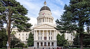
Sacramento, California
Capital city of California, United States
Distance: Approx. 449 meters
Latitude and longitude: 38.58166667,-121.49444444
Sacramento ( SAK-rə-MEN-toh; Spanish: [sakɾaˈmento]; Spanish for 'sacrament') is the capital city of the U.S. state of California and the seat of Sacramento County. Located at the confluence of the Sacramento and American Rivers in Northern California's Sacramento Valley, Sacramento's 2020 population of 524,943 makes it the fourth-most populous city in Northern California, the sixth-most populous in the state, the ninth-most populous state capital,and the 35th most populous in the United States. Sacramento is the seat of the California Legislature and the governor of California.

Alkali Flat/La Valentina station
Distance: Approx. 387 meters
Latitude and longitude: 38.58555556,-121.48805556
Alkali Flat/La Valentina station is an at-grade light rail station on the Blue Line of the SacRT light rail system operated by the Sacramento Regional Transit District. The station is located alongside 12th Street at its intersection with D Street, in the Alkali Flat Historic District, after which the station is named, in the city of Sacramento, California.

Pacific Legal Foundation
American libertarian public interest law firm
Distance: Approx. 223 meters
Latitude and longitude: 38.5834,-121.4924
The Pacific Legal Foundation (PLF) is an American nonprofit public interest law firm established for the purpose of defending and promoting individual freedom. PLF attorneys provide pro bono legal representation, file amicus curiae briefs, and hold administrative proceedings with the stated goal of supporting property rights, equality and opportunity, and the separation of powers. The organization is the first and oldest libertarian public interest law firm, having been founded in 1973.

Mesick House
Historic house in California, United States
Distance: Approx. 130 meters
Latitude and longitude: 38.58582778,-121.49388611
Mesick House is a historic home constructed in 1875 in the Second Empire and Italianate Victorian architecture styles. It is one of four High Victorians remaining in Sacramento that display a mansard roof (the others being Stanford Mansion, Heilbron Mansion, and Governors Mansion). The home gets its name from its original owner, Mary Mesick.

J. Neely Johnson House
Historic house in California, United States
Distance: Approx. 193 meters
Latitude and longitude: 38.58460278,-121.49053056
The J. Neely Johnson House is a Greek Revival style Neoclassical historic home built in 1853, located in Sacramento, California. It was added to the National Register of Historic Places in 1976. In 1856 it was a home of John Neely Johnson, fourth governor of California.

Federal Building (Sacramento)
United States historic place
Distance: Approx. 395 meters
Latitude and longitude: 38.58236111,-121.49483333
The Federal Building, formerly the U.S. Post Office, Courthouse and Federal Building, is located in Downtown Sacramento, California.
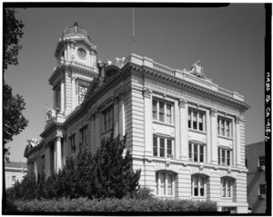
Sacramento City Hall
Distance: Approx. 401 meters
Latitude and longitude: 38.58189,-121.49355
Sacramento City Hall is a five-story, 267,000-square-foot building that combines modern and historic structures in Sacramento, California. The building can house up to 730 staff members. Prominent local architect Rudolph A. Herold designed the building in 1908.
Sacramento County Public Law Library
Distance: Approx. 81 meters
Latitude and longitude: 38.58473,-121.49285
The Sacramento County Public Law Library (SCPLL) is a public law library in the capital city of the State of California. In 1891 the state of California enacted statutes mandating an independent law library in every county. Since its inception SCPLL has provided free public access to legal information.

Cal/EPA Building
Skyscraper in California, United States
Distance: Approx. 447 meters
Latitude and longitude: 38.58138889,-121.4925
The Cal/EPA Building is a 25-floor, 372 ft commercial office skyscraper in Downtown Sacramento that serves as the headquarters for the California Environmental Protection Agency (Cal/EPA). It also known as the Joe Serna Jr. Building, named to honor the late mayor of Sacramento, Joe Serna Jr.

Alkali Flat Historic District
Historic district in Sacramento, California
Distance: Approx. 264 meters
Latitude and longitude: 38.584444,-121.489722
The Alkali Flat Historic District is a historic district in Sacramento, California. It is the oldest surviving neighborhood in Sacramento. The older Alkali Flat buildings and homes were built between 1853 and 1869 by the Sacramento's upper class.

Saint Andrews African Methodist Episcopal Church (Sacramento, California)
Historical church in California, US
Distance: Approx. 334 meters
Latitude and longitude: 38.584217,-121.496033
The Saint Andrews African Methodist Episcopal Church is an African Methodist Episcopal Church in Sacramento, California, founded in 1850. It was the first African American church in California and the first AME Church on the West Coast of the United States. It was originally located at 715 Seventh Street, which is marked by a historical plaque.

Julius Wetzlar House
Historic house in California, United States
Distance: Approx. 297 meters
Latitude and longitude: 38.58283333,-121.49158333
The Julius Wetzlar House located in Sacramento, California is a historic house built in 1871 and designed in an Italianate style.
Weather in this IP's area
clear sky
6 Celsius
5 Celsius
4 Celsius
7 Celsius
1025 hPa
89 %
1025 hPa
1024 hPa
10000 meters
1.54 m/s
310 degree