136.175.64.58 - IP Lookup: Free IP Address Lookup, Postal Code Lookup, IP Location Lookup, IP ASN, Public IP
Country:
Region:
City:
Location:
Time Zone:
Postal Code:
IP information under different IP Channel
ip-api
Country
Region
City
ASN
Time Zone
ISP
Blacklist
Proxy
Latitude
Longitude
Postal
Route
Luminati
Country
Region
pa
City
lewistown
ASN
Time Zone
America/New_York
ISP
MIFFLIN-COUNTY-WIRELESS
Latitude
Longitude
Postal
IPinfo
Country
Region
City
ASN
Time Zone
ISP
Blacklist
Proxy
Latitude
Longitude
Postal
Route
IP2Location
136.175.64.58Country
Region
pennsylvania
City
state college
Time Zone
America/New_York
ISP
Language
User-Agent
Latitude
Longitude
Postal
db-ip
Country
Region
City
ASN
Time Zone
ISP
Blacklist
Proxy
Latitude
Longitude
Postal
Route
ipdata
Country
Region
City
ASN
Time Zone
ISP
Blacklist
Proxy
Latitude
Longitude
Postal
Route
Popular places and events near this IP address

State College, Pennsylvania
Home rule municipality in Pennsylvania, United States
Distance: Approx. 251 meters
Latitude and longitude: 40.79138889,-77.85861111
State College is a borough and home rule municipality in Centre County, Pennsylvania, United States. It is a college town, dominated economically, culturally, and demographically by the presence of the University Park campus of The Pennsylvania State University. State College is the largest designated borough in Pennsylvania.
Pennsylvania State University
Public university in the United States
Distance: Approx. 561 meters
Latitude and longitude: 40.79833333,-77.86
The Pennsylvania State University (commonly referred to as Penn State and sometimes by the acronym PSU) is a public state-related land-grant research university with campuses and facilities throughout Pennsylvania, United States. Founded in 1855 as Farmers' High School of Pennsylvania, Penn State was named the state's first land-grant university eight years later, in 1863. Its primary campus, known as Penn State University Park, is located in State College and College Township.

Old Main (Pennsylvania State University)
University administration, Clock Tower in University Park, Pennsylvania
Distance: Approx. 418 meters
Latitude and longitude: 40.79647,-77.86286
Old Main (originally called "Main Building") is The Pennsylvania State University's first building of major significance. First completed in 1867, the current incarnation of the building was completed in 1930. Today, Old Main serves as the administrative center of Penn State, housing the offices of the president and other officials.

Schreyer Honors College
College Honors Program
Distance: Approx. 520 meters
Latitude and longitude: 40.79771,-77.85815
The Schreyer Honors College (or SHC) is the honors program of the Pennsylvania State University. Founded in 1980 as the University Scholars Program, it was expanded and renamed in 1997 in response to a $30 million gift by William and Joan Schreyer. Schreyer was one of three honors colleges, along with those at Arizona State and Mississippi, to be listed by Reader's Digest in its "America's 100 Best" list published in May, 2005.

Central Pennsylvania Festival of the Arts
Distance: Approx. 169 meters
Latitude and longitude: 40.79441,-77.86157
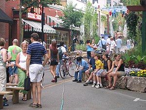
The Central Pennsylvania Festival of the Arts, officially abbreviated as CPFA, is held each summer in State College, Pennsylvania and on the main (University Park) campus of Pennsylvania State University. Penn State students and locals commonly refer to the event as Arts Fest.
Schlow Centre Region Library
Distance: Approx. 36 meters
Latitude and longitude: 40.7934,-77.8598
The Schlow Centre Region Library, formerly known as the State College Public Library and the Schlow Memorial Library, serves the State College, Pennsylvania area.

Octacube (sculpture)
Sculpture in Pennsylvania State University's mathematics department
Distance: Approx. 510 meters
Latitude and longitude: 40.79763889,-77.86213889
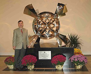
The Octacube is a large, stainless steel sculpture displayed in the mathematics department of Pennsylvania State University in State College, PA. The sculpture represents a mathematical object called the 24-cell or "octacube". Because a real 24-cell is four-dimensional, the artwork is actually a projection into the three-dimensional world. Octacube has very high intrinsic symmetry, which matches features in chemistry (molecular symmetry) and physics (quantum field theory).
Donald P. Bellisario College of Communications
Distance: Approx. 529 meters
Latitude and longitude: 40.79647,-77.86487
The Donald P. Bellisario College of Communications is the undergraduate and graduate college dedicated to the study of journalism, mass communications and media at Pennsylvania State University. Re-established in 2017 under its new name after the producer, screenwriter and benefactor Donald P. Bellisario, the Bellisario College is home to four departments: Advertising/Public Relations, Journalism, Film Production and Media Studies, and Telecommunications and Media Industries. Offering five undergraduate majors, a master's degree in media studies, and a Ph.D. program in mass communications, the college is the largest accredited program of its kind in the United States.
State Theatre (State College, Pennsylvania)
Distance: Approx. 167 meters
Latitude and longitude: 40.793634,-77.862133
The State Theatre is a 554-seat non-profit community theatre in State College, Pennsylvania. It currently operates as one of the cultural hubs of music, cinema, and live performances for downtown State College and the Centre County region.
Holmes–Foster–Highlands Historic District
Historic district in Pennsylvania, United States
Distance: Approx. 160 meters
Latitude and longitude: 40.79194444,-77.86083333
The Holmes–Foster–Highlands Historic District is a national historic district located in State College, Centre County, Pennsylvania. It was added to the National Register of Historic Places in 1995.

Farmers' High School
United States historic place
Distance: Approx. 407 meters
Latitude and longitude: 40.79638889,-77.86277778
Farmers' High School is a national historic district located on the campus of the Pennsylvania State University in University Park / State College, Centre County, Pennsylvania. The district includes 37 contributing buildings and 1 contributing object in the Old Campus area of Penn State. The district includes Old Main (1930), the Faculty Club (1976), Nittany Lion Inn (1930), Recreation Hall (1928), West Halls Complex (1922-1937), University Club (1916), the President's Mansion (1864, 1940), Pattee Library (1938), Schwab Auditorium (1902), and a number of fraternities, sororities, and classroom buildings.
Camelot (State College, Pennsylvania)
Historic house in Pennsylvania, United States
Distance: Approx. 523 meters
Latitude and longitude: 40.78888889,-77.85805556
Camelot is a historic home located at State College, Centre County, Pennsylvania. It was built starting in 1922, and is a two-story rambling frame dwelling, covered with stucco and dressed in limestone. It features a roof that consists of a series of five main interconnecting gables with gable overhang.
Weather in this IP's area
overcast clouds
-2 Celsius
-8 Celsius
-3 Celsius
-1 Celsius
1019 hPa
66 %
1019 hPa
967 hPa
10000 meters
6.17 m/s
8.75 m/s
270 degree
100 %

