Country:
Region:
City:
Latitude and Longitude:
Time Zone:
Postal Code:
IP information under different IP Channel
ip-api
Country
Region
City
ASN
Time Zone
ISP
Blacklist
Proxy
Latitude
Longitude
Postal
Route
Luminati
Country
ASN
Time Zone
America/Chicago
ISP
AMAZON-AES
Latitude
Longitude
Postal
IPinfo
Country
Region
City
ASN
Time Zone
ISP
Blacklist
Proxy
Latitude
Longitude
Postal
Route
db-ip
Country
Region
City
ASN
Time Zone
ISP
Blacklist
Proxy
Latitude
Longitude
Postal
Route
ipdata
Country
Region
City
ASN
Time Zone
ISP
Blacklist
Proxy
Latitude
Longitude
Postal
Route
Popular places and events near this IP address

Gadsby's Tavern
Historic commercial building in Virginia, United States
Distance: Approx. 123 meters
Latitude and longitude: 38.80555556,-77.04361111
Gadsby's Tavern is a complex of historic buildings at 134 and 138 North Royal Street at the corner of Cameron Street in the Old Town district of Alexandria, Virginia. The complex includes a c.1785 tavern, the 1792 City Tavern and Hotel, and an 1878 hotel addition. The taverns were a central part of the social, economic, political, and educational life of the city of Alexandria at the time.

Carlyle House
Historic house in Virginia, United States
Distance: Approx. 233 meters
Latitude and longitude: 38.80527778,-77.04222222
Carlyle House is a historic mansion in Alexandria, Virginia, United States, built by Scottish merchant John Carlyle from 1751 to 1752 in the Georgian style. It is situated in the city's Old Town at 121 North Fairfax Street between Cameron and King Street. To the west, the Gadsby's Tavern is found one block away and Christ Church is three blocks away.

Alexandria Historic District
National Historic Landmark District in Alexandria, Virginia, United States
Distance: Approx. 235 meters
Latitude and longitude: 38.80333333,-77.04638889
The Alexandria Historic District is a National Historic Landmark District in Alexandria, Virginia. Encompassing all of the city's Old Town and some adjacent areas, this area contains one of the nation's best-preserved assemblages of the late-18th and early-19th century urban architecture. The district was locally designated (as the Old and Historic Alexandria district) in 1946 and was declared a National Historic Landmark in 1966.

Stabler-Leadbeater Apothecary Shop
Historic commercial building in Virginia, United States
Distance: Approx. 212 meters
Latitude and longitude: 38.80472222,-77.0425
The Stabler-Leadbeater Apothecary Shop/Museum is a historic apothecary's shop in Alexandria, Virginia, that has been preserved as a museum. During its working life, it was owned by generations of a Quaker family. Eventually, a dramatic decline in sales during the Great Depression forced the shop to close its doors.

Bank of Alexandria (Alexandria, Virginia)
Historic commercial building in Virginia, United States
Distance: Approx. 209 meters
Latitude and longitude: 38.80527778,-77.0425
The Bank of Alexandria is a historic bank building located at Alexandria, Virginia, United States. It was built in 1807, and consists of a three-story main block, with a two-story east wing. The main block is five bays wide and 7 bays deep.

St. Paul's Episcopal Church (Alexandria, Virginia)
Historic church in Virginia, United States
Distance: Approx. 230 meters
Latitude and longitude: 38.80305556,-77.04527778
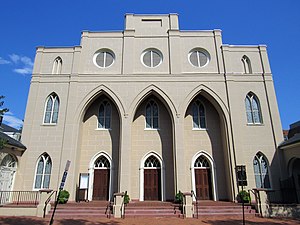
St. Paul's Episcopal Church is an historic Episcopal church in the Anglican Communion located in the Old Town area of Alexandria, Virginia. The church, consecrated in 1818, was designed by Benjamin Latrobe, the second architect of the United States Capitol.

Marshall House (Alexandria, Virginia)
Hotel in Virginia, United States
Distance: Approx. 53 meters
Latitude and longitude: 38.80469444,-77.04456944
The Marshall House was an inn that stood at 480 King Street (near the southeast corner of King Street and South Pitt Street) in Alexandria, Virginia. At the beginning of the American Civil War in 1861, the house was the site of the killing of Col. Elmer E. Ellsworth during the Union Army's takeover of Alexandria.

Alexandria City Hall
United States historic place
Distance: Approx. 112 meters
Latitude and longitude: 38.805,-77.04361111
The Alexandria City Hall also known as the Alexandria Market House & City Hall, in Alexandria, Virginia, is a building built in 1871 and designed by Adolph Cluss. In 1984, the building was listed on the U.S. National Register of Historic Places. The site was originally a market from 1749 and a courthouse from 1752.

Appomattox (statue)
Bronze statue in Virginia, United States
Distance: Approx. 239 meters
Latitude and longitude: 38.80391667,-77.04719444
Appomattox is a bronze statue commemorating soldiers from Alexandria, Virginia, who had died while fighting for the Confederacy during the American Civil War. The memorial was located in the center of the intersection of South Washington Street (Virginia Route 400) and Prince Street in the Old Town neighborhood of Alexandria. The National Park Service placed the monument on the National Register of Historic Places during 2017.
Alexandria Fire Department
Fire department in Alexandria, Virginia, US
Distance: Approx. 206 meters
Latitude and longitude: 38.80472222,-77.04722222
The Alexandria Fire Department (AFD) provides fire protection and emergency medical services to the city of Alexandria, Virginia. Established in 1866, the department is responsible for 15 square miles (39 km2) with a population of over 159,000.

Mansion House Hospital
Hotel in Virginia, United States
Distance: Approx. 233 meters
Latitude and longitude: 38.80527778,-77.04222222
Mansion House Hospital was a Union hospital during the American Civil War, formed after Union occupation of Alexandria, Virginia and the seizure of the Mansion House Hotel.

Hollensbury Spite House
Building in Virginia, United States
Distance: Approx. 234 meters
Latitude and longitude: 38.80719444,-77.04508333
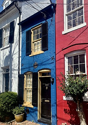
The Hollensbury Spite House is a spite house located at 523 Queen Street in Alexandria, Virginia. The narrow building measures 7-feet 6-inches (2.3 m) wide and is often called the skinniest house in the United States. The house has drawn international attention, being covered by numerous news outlets, and was once featured on The Oprah Winfrey Show.
Weather in this IP's area
light rain
9 Celsius
8 Celsius
8 Celsius
10 Celsius
1017 hPa
90 %
1017 hPa
1016 hPa
10000 meters
1.54 m/s
90 degree
100 %
06:50:11
16:55:26