Country:
 USA
USARegion:
City:
Latitude and Longitude:
Time Zone:
Postal Code:
IP information under different IP Channel
ip-api
Country
Region
City
ASN
Time Zone
ISP
Blacklist
Proxy
Latitude
Longitude
Postal
Route
IPinfo
Country
Region
City
ASN
Time Zone
ISP
Blacklist
Proxy
Latitude
Longitude
Postal
Route
MaxMind
Country
Region
City
ASN
Time Zone
ISP
Blacklist
Proxy
Latitude
Longitude
Postal
Route
Luminati
Country
USASN
Time Zone
America/Chicago
ISP
Stark Industries Solutions Ltd
Latitude
Longitude
Postal
db-ip
Country
Region
City
ASN
Time Zone
ISP
Blacklist
Proxy
Latitude
Longitude
Postal
Route
ipdata
Country
Region
City
ASN
Time Zone
ISP
Blacklist
Proxy
Latitude
Longitude
Postal
Route
Popular places and events near this IP address

Westin Peachtree Plaza Hotel
Skyscraper hotel in downtown Atlanta, Georgia, United States
Distance: Approx. 140 meters
Latitude and longitude: 33.75943,-84.38855
The Westin Peachtree Plaza, Atlanta, is a skyscraper hotel on Peachtree Street in downtown Atlanta, Georgia, adjacent to the Peachtree Center complex and the former Davison's/Macy's flagship store with 1,073 rooms. At 723.0 ft (220.37 m) and 73 stories, a total building area of 1,196,240 sq ft (111,134 m2) and a 187 ft (57 m) diameter, the tower is the fourth-tallest hotel in the Western Hemisphere, and the 30th tallest all-hotel building in the world.

Tabernacle (concert hall)
Concert hall in Downtown Atlanta, Georgia, United States
Distance: Approx. 197 meters
Latitude and longitude: 33.75874,-84.39139
The Tabernacle is a mid-size concert hall located in Downtown Atlanta, Georgia. Opening in 1911 as a church, the building was converted into a music venue in 1996. It is owned and managed by concert promoter Live Nation Entertainment and has a capacity of 2,600 people.

American Cancer Society Center
Building in Atlanta, GA
Distance: Approx. 151 meters
Latitude and longitude: 33.761,-84.391
The American Cancer Society Center (ACS Center) is a large convention center and office building in downtown Atlanta, adjacent to Centennial Olympic Park. The building contains about 1,500,000 square feet (140,000 m2), including a partially underground parking garage and loading area. The building, originally called the Inforum Technology Center or Inforum, was designed by the prominent Atlanta architect John Portman, who previously designed the AmericasMart buildings.

Peachtree Center
Human settlement in Atlanta, Georgia, US
Distance: Approx. 208 meters
Latitude and longitude: 33.7604,-84.3877
Peachtree Center is a district located in Downtown Atlanta, Georgia. Most of the structures that make up the district were designed by Atlanta architect John C. Portman Jr. A defining feature of the Peachtree Center is a network of enclosed pedestrian sky bridges suspended above the street-level, which have garnered criticism for discouraging pedestrian street life.

AmericasMart
Distance: Approx. 206 meters
Latitude and longitude: 33.760473,-84.387751
AmericasMart Atlanta is a wholesale trade center located in Downtown Atlanta, Georgia. The exhibition center is one of the largest permanent wholesale trade centers in the world. AmericasMart Atlanta consists of three buildings totaling seven million square feet.
Capital City Club
United States historic place
Distance: Approx. 217 meters
Latitude and longitude: 33.76083333,-84.38777778
The Capital City Club is a private social club located in Atlanta, Georgia. Chartered on May 21, 1883, it is one of the oldest private clubs in the South.

Hotel District
Neighborhood in Atlanta, United States
Distance: Approx. 217 meters
Latitude and longitude: 33.75969,-84.387589
The Hotel District is a neighborhood in Downtown Atlanta, Georgia, United States. The district's name is derived from it being the home to many hotels, one of them being the famous Westin Peachtree Plaza Hotel. The Hotel District is generally considered to be bounded by the Downtown Connector to the east, Five Points to the south, Centennial Olympic Park to the west, and Midtown to the north.

Henry Grady Hotel
Distance: Approx. 206 meters
Latitude and longitude: 33.75944444,-84.38777778
The Henry Grady Hotel was a hotel in downtown Atlanta, Georgia, United States. The building, designed by architect G. Lloyd Preacher, was completed in 1924 at the intersection of Peachtree Street and Cain Street, on land owned by the government of Georgia that had previously been occupied by the official residence of the governor. The hotel, which was named after journalist Henry W. Grady, was owned by the state and leased to operators.
1947 Women's Western Open
Distance: Approx. 217 meters
Latitude and longitude: 33.76083333,-84.38777778
The 1947 Women's Western Open was a golf competition held at Capital City Club, the 18th edition of the event. Louise Suggs won the championship in match play competition by defeating Dorothy Kirby in the final match, 4 and 2.
1953 Women's Western Open
Distance: Approx. 217 meters
Latitude and longitude: 33.76083333,-84.38777778
The 1953 Women's Western Open was a golf competition held at Capital City Club, the 24th edition of the event. Louise Suggs won the championship in match play competition by defeating Patty Berg in the final match, 6 and 5.

Leyden House
Distance: Approx. 218 meters
Latitude and longitude: 33.758979,-84.387889
The Leyden House (1858 or 1859–1913) was one of Atlanta's most historic homes. It was located on 124 Peachtree Street NE between Cain (now Andrew Young International Blvd.) and Ellis streets. The architect was John Boutell.

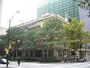
Bona Allen Building
Building in Atlanta, Georgia
Distance: Approx. 169 meters
Latitude and longitude: 33.7586,-84.3906
The Bona Allen Building is a historic nine-story office building, built in 1917, in downtown Atlanta, Georgia. It was designed by architect John F. Downing. It later became known as the Turner Building.
Weather in this IP's area
clear sky
12 Celsius
10 Celsius
10 Celsius
13 Celsius
1032 hPa
65 %
1032 hPa
994 hPa
10000 meters
3.09 m/s
80 degree
07:45:02
18:59:51