Country:
 USA
USARegion:
City:
Latitude and Longitude:
Time Zone:
Postal Code:
IP information under different IP Channel
ip-api
Country
Region
City
ASN
Time Zone
ISP
Blacklist
Proxy
Latitude
Longitude
Postal
Route
IPinfo
Country
Region
City
ASN
Time Zone
ISP
Blacklist
Proxy
Latitude
Longitude
Postal
Route
MaxMind
Country
Region
City
ASN
Time Zone
ISP
Blacklist
Proxy
Latitude
Longitude
Postal
Route
Luminati
Country
USRegion
ca
City
berkeley
ASN
Time Zone
America/Los_Angeles
ISP
AS-SONICTELECOM
Latitude
Longitude
Postal
db-ip
Country
Region
City
ASN
Time Zone
ISP
Blacklist
Proxy
Latitude
Longitude
Postal
Route
ipdata
Country
Region
City
ASN
Time Zone
ISP
Blacklist
Proxy
Latitude
Longitude
Postal
Route
Popular places and events near this IP address

Belmont, California
City in the US state of California
Distance: Approx. 496 meters
Latitude and longitude: 37.51805556,-122.29166667
Belmont is a city in San Mateo County in the U.S. state of California. It is in the San Francisco Bay Area, on the San Francisco Peninsula about halfway between San Francisco and San Jose. It was originally part of Rancho de las Pulgas, for which one of its main roads, the Alameda de las Pulgas, is named.
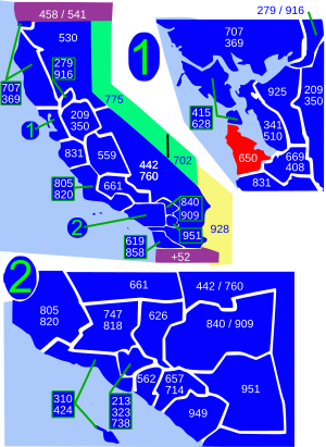
Area code 650
Area code for San Mateo County and parts of Santa Clara County, California
Distance: Approx. 1686 meters
Latitude and longitude: 37.5,-122.3
Area code 650 is a telephone area code in the North American Numbering Plan (NANP) for the San Francisco Bay Area in the U.S. state of California. It was split from area code 415 on August 2, 1997, and includes most of San Mateo County (except the northernmost portion), part of San Francisco, and the northwestern portion of Santa Clara County including Palo Alto, Mountain View, and Los Altos. Prior to October 2021, area code 650 had telephone numbers assigned for the central office code 988.

Ralston Hall
Historic house in Belmont, California
Distance: Approx. 651 meters
Latitude and longitude: 37.5175,-122.28611111
Ralston Hall Mansion located in Belmont, California, was the country house of William Chapman Ralston, a San Francisco businessman, a founder of the Bank of California, and a financier of the Comstock Lode. It is an opulent Italianate Villa, modified with touches of Steamboat Gothic and Victorian details. It is a California Historical Landmark and is designated a National Historic Landmark.
San Carlos Charter Learning Center
Charter school in California, United States
Distance: Approx. 685 meters
Latitude and longitude: 37.5096,-122.2857
The San Carlos Charter Learning Center (SCCLC) is a charter school in San Carlos, California, United States. It was the first charter school in California and the second in the nation. It was created in 1994.
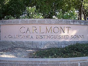
Carlmont High School
Public high school in Belmont, California
Distance: Approx. 823 meters
Latitude and longitude: 37.5063,-122.2901
Carlmont High School is a public high school in Belmont, California, United States serving grades 9–12 as part of the Sequoia Union High School District. Carlmont is a California Distinguished School. Carlmont was founded in 1952 as "a school within a school" at Sequoia High School, with four hundred fifty freshman and sophomore students.
Notre Dame High School (Belmont, California)
Catholic school for women in California, US
Distance: Approx. 529 meters
Latitude and longitude: 37.5153,-122.286
Notre Dame High School, Belmont is a Catholic women's college preparatory high school located in the San Mateo County suburb of Belmont, California. The school is operated by the Sisters of Notre Dame de Namur for the Archdiocese of San Francisco. The school's mission is driven by the teachings of Saint Julie Billiart, the foundress of the Sisters of Notre Dame de Namur.
Notre Dame de Namur University
Private Catholic university in Belmont, California, United States
Distance: Approx. 755 meters
Latitude and longitude: 37.51729,-122.28443
Notre Dame de Namur University (NDNU) is a private Catholic university in Belmont, California. It is the third oldest college in California and the first college in the state authorized to grant the baccalaureate degree to women. In 2021, the university began to transition to only operate as a graduate school.

Belmont station (Caltrain)
Train station in Belmont, California, U.S.
Distance: Approx. 1599 meters
Latitude and longitude: 37.52138889,-122.27638889
Belmont station is a Caltrain station in Belmont, California that replaced the Southern Pacific Railroad station nearby. It is served by local and limited service trains. The modern elevated station was constructed in 1997 as part of a grade separation project.
Tierra Linda Middle School
Public middle school
Distance: Approx. 834 meters
Latitude and longitude: 37.5093571,-122.2838193
Tierra Linda Middle School is a middle school in San Carlos, California, United States, founded in 1953. It is one of two middle schools within the San Carlos Elementary School District, and since 2018, has served students in grades 6–8. Due to changing enrollment, the school was closed in 1982, but reopened in 2000.
Charles Armstrong School
Distance: Approx. 770 meters
Latitude and longitude: 37.51083333,-122.28361111
Charles Armstrong School, located in Belmont, California, is an independent, non-profit, co-educational lower and middle day school specializing in teaching students with language-based learning differences, such as dyslexia. Armstrong helps its students re-enter traditional public and private schools with the learning tools necessary to be language proficient. Tuition, grants and donations support Charles Armstrong School, which is the only school of its kind in the San Francisco Bay Area.
Davey Glen Park
Distance: Approx. 1343 meters
Latitude and longitude: 37.524862,-122.286134
Davey Glen Park is a 1-acre (4,000 m2) piece of parkland set aside by the city of Belmont, California, in 2000 as part of an upscale housing development nearby. Donation of land for parks or in-lieu fees are required by the city for such development. In this case, The developer donated land valued at approximately $450,000 to the City of Belmont Parks Department in 2000 for use as a park.

Nathanial Brittan Party House
United States historic place
Distance: Approx. 2256 meters
Latitude and longitude: 37.50041667,-122.27219444
The Nathanial Brittan Party House, also known as Nathaniel Brittan Party House, Brittan Party House, Brittan Lodge, is located at 125 Dale Avenue in San Carlos, California, and was built in 1872. It was listed on the National Register of Historic Places in 1994.
Weather in this IP's area
clear sky
21 Celsius
21 Celsius
17 Celsius
25 Celsius
1011 hPa
66 %
1011 hPa
1007 hPa
10000 meters
7.72 m/s
10 degree
06:54:58
19:10:37