Country:
 USA
USARegion:
City:
Latitude and Longitude:
Time Zone:
Postal Code:
IP information under different IP Channel
ip-api
Country
Region
City
ASN
Time Zone
ISP
Blacklist
Proxy
Latitude
Longitude
Postal
Route
IPinfo
Country
Region
City
ASN
Time Zone
ISP
Blacklist
Proxy
Latitude
Longitude
Postal
Route
MaxMind
Country
Region
City
ASN
Time Zone
ISP
Blacklist
Proxy
Latitude
Longitude
Postal
Route
Luminati
Country
USRegion
ca
City
oakland
ASN
Time Zone
America/Los_Angeles
ISP
AS-SONICTELECOM
Latitude
Longitude
Postal
db-ip
Country
Region
City
ASN
Time Zone
ISP
Blacklist
Proxy
Latitude
Longitude
Postal
Route
ipdata
Country
Region
City
ASN
Time Zone
ISP
Blacklist
Proxy
Latitude
Longitude
Postal
Route
Popular places and events near this IP address
East Bay Municipal Utility District
Distance: Approx. 1453 meters
Latitude and longitude: 37.8,-122.2
East Bay Municipal Utility District (EBMUD), colloquially referred to as "East Bay Mud", is a public utility district which provides water and sewage treatment services for an area of approximately 331 square miles (860 km2) in the eastern side of the San Francisco Bay. As of 2018, EBMUD provides drinking water for approximately 1.4 million people in portions of Alameda County and Contra Costa County in California, including the cities of Richmond, El Cerrito, Hercules, San Pablo, Pinole, Lafayette, Moraga, Orinda, Danville, Oakland, Piedmont, Emeryville, Berkeley, Albany, Alameda, San Leandro, neighboring unincorporated regions, and portions of cities such as Hayward and San Ramon. Sewage treatment services are provided for 685,000 people in an 88-square-mile area (as of 2018).

Head-Royce School
Private school in Oakland, California, United States
Distance: Approx. 1008 meters
Latitude and longitude: 37.80802,-122.20515
Head-Royce School (Head-Royce or HRS) is a private co-educational college-preparatory K-12 school in Oakland, California. The forerunner of Head-Royce was the Anna Head School for Girls in Berkeley, founded in 1887. Relocated to its current site in 1964, Anna Head School for Girls merged with the neighboring Royce School in 1979 to form the present-day Head-Royce School.
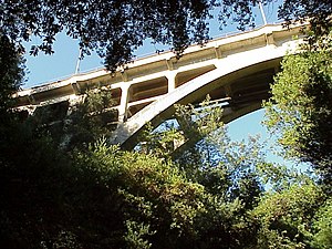
Leimert Bridge
Bridge in Oakland, California
Distance: Approx. 911 meters
Latitude and longitude: 37.81228333,-122.213325
Leimert Bridge is located in the Oakmore neighborhood of Oakland, California. It spans 357 ft (109 m) and is 117 ft (36 m) high above Sausal Creek. It is a cement and steel arch bridge.
Ascension Greek Orthodox Cathedral of Oakland
Church in California, United States of America
Distance: Approx. 1400 meters
Latitude and longitude: 37.809578,-122.20115
The Ascension Greek Orthodox Cathedral is an Eastern Orthodox cathedral church in Oakland, California. It is located at 4700 Lincoln Avenue.

Oakland California Temple
Latter-day Saints Temple in Oakland, California, US
Distance: Approx. 1503 meters
Latitude and longitude: 37.8078,-122.1991
The Oakland California Temple (formerly the Oakland Temple) is a temple of the Church of Jesus Christ of Latter-day Saints in Oakland, California. Notable for its five-spire design influenced by Asian architecture, the temple stands on a hill with panoramic views of the San Francisco Bay Area. The complex, sometimes referred to as Temple Hill, includes a visitors' center, a church employment center, a materials distribution center, an auditorium, an inter-stake center, a rooftop terrace, and gardens where photoshoots for quinceañeras and other celebrations take place.

Dimond District, Oakland, California
Neighborhood of Oakland in Alameda, California, United States
Distance: Approx. 271 meters
Latitude and longitude: 37.80333333,-122.21277778
The Dimond District () is a neighborhood centered on the intersection of MacArthur Boulevard and Fruitvale Avenue in East Oakland, California, in the United States. It is located about two miles east of Lake Merritt, north of the Fruitvale District, and west of the Laurel District. It lies at an elevation of 213 feet (65 m).
Glenview, Oakland, California
Neighborhood of Oakland in Alameda, California, United States
Distance: Approx. 557 meters
Latitude and longitude: 37.80612683,-122.22149283
Glenview is a neighborhood in Oakland, California developed in the early decades of the 20th century, mostly with mid-sized 2 and 3-bedroom craftsman bungalows. The neighborhood lies in the Oakland foothills, bordering Dimond Park on the eastern side of the district, and Park Boulevard on the northwestern side. The upper portion of the neighborhood sits on the west side of Park Boulevard and is bordered by the Trestle Glen neighborhood as well as the City of Piedmont.
Oakmore, Oakland, California
Distance: Approx. 1088 meters
Latitude and longitude: 37.81120833,-122.20685
Oakmore is a neighborhood in Oakland, California located east of Park Boulevard and north of Dimond Park. This neighborhood was built in the 1920s and 1930s for people who worked in San Francisco and took the Key Route to work. The Key System was a primary user of the Leimert Bridge, which connects Oakmore to Park Boulevard.
Crocker Highlands, Oakland, California
Distance: Approx. 1350 meters
Latitude and longitude: 37.81333333,-122.22583333
Crocker Highlands is a neighborhood located in the north-eastern area of Oakland, California, United States.
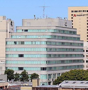
Highland Hospital (Oakland, California)
Hospital in California, United States
Distance: Approx. 1558 meters
Latitude and longitude: 37.7983,-122.2316
Highland Hospital is a public hospital in Alameda County, Oakland, California. It is operated by the Alameda Health System. It is the primary trauma center and a county hospital in Alameda County.

Highland Park, Oakland, California
Neighborhood of Oakland, California, US
Distance: Approx. 1274 meters
Latitude and longitude: 37.79777778,-122.2275
Highland Park is a neighborhood in Oakland in Alameda County, California. It lies at an elevation of 194 feet (59 m).

Altenheim (Oakland, California)
Historic place in Oakland, California
Distance: Approx. 602 meters
Latitude and longitude: 37.800786,-122.2208
Altenheim are historical buildings in Oakland, California. The Altenheim buildings were started in 1908. The buildings were listed to the National Register of Historic Places on January 10, 2007.
Weather in this IP's area
few clouds
21 Celsius
20 Celsius
17 Celsius
26 Celsius
1011 hPa
67 %
1011 hPa
1004 hPa
10000 meters
5.66 m/s
290 degree
20 %
06:54:36
19:10:22