Country:
 USA
USARegion:
City:
Latitude and Longitude:
Time Zone:
Postal Code:
IP information under different IP Channel
ip-api
Country
Region
City
ASN
Time Zone
ISP
Blacklist
Proxy
Latitude
Longitude
Postal
Route
IPinfo
Country
Region
City
ASN
Time Zone
ISP
Blacklist
Proxy
Latitude
Longitude
Postal
Route
MaxMind
Country
Region
City
ASN
Time Zone
ISP
Blacklist
Proxy
Latitude
Longitude
Postal
Route
Luminati
Country
USRegion
ca
City
petaluma
ASN
Time Zone
America/Los_Angeles
ISP
AS-SONICTELECOM
Latitude
Longitude
Postal
db-ip
Country
Region
City
ASN
Time Zone
ISP
Blacklist
Proxy
Latitude
Longitude
Postal
Route
ipdata
Country
Region
City
ASN
Time Zone
ISP
Blacklist
Proxy
Latitude
Longitude
Postal
Route
Popular places and events near this IP address
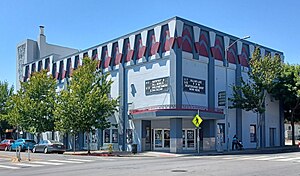
Phoenix Theater
All-ages nightclub in Petaluma, California
Distance: Approx. 3222 meters
Latitude and longitude: 38.235001,-122.643056
The Phoenix Theater is an all-ages nightclub located in Petaluma, California. The club has been in existence since 1905 and has changed in both structure and purpose, mostly due to severe damage caused by several fires.

Lagunitas Brewing Company
1993-2015 craft brewery; then became Heineken subsidiary
Distance: Approx. 3429 meters
Latitude and longitude: 38.2725,-122.6625
The Lagunitas Brewing Company, founded in 1993 in Petaluma, California, is a subsidiary of Heineken International. Before Heineken bought a 50% share of the company in 2015, the company met the definition of a craft brewery. Two years prior it ranked fifth top-selling craft brewery in the US. Heineken purchased the remainder of the company in 2017.

Old Petaluma Opera House
United States historic place
Distance: Approx. 3407 meters
Latitude and longitude: 38.235,-122.64083333
The Old Petaluma Opera House (also known as the Maclay Building) is a historic building located in downtown Petaluma, California.
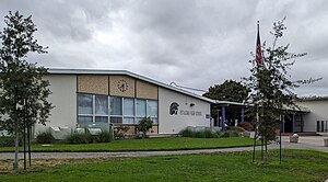
Petaluma High School
Public school in Petaluma, California, United States
Distance: Approx. 3386 meters
Latitude and longitude: 38.22694444,-122.64611111
Petaluma High School is located one mile from historic downtown Petaluma in California. It is a comprehensive public high school with approximately 1,310 students in grades 9–12, serving the west side of Petaluma and many of the rural areas that surround the city in both Sonoma County and Marin County.
Petaluma Gap
Geographical region in California
Distance: Approx. 2024 meters
Latitude and longitude: 38.25055,-122.69969
The Petaluma Gap is a geographical region in Sonoma County, California which extends in a band from the Pacific Ocean to San Pablo Bay. It is an area of low land 22 to 31 miles (35 to 50 kilometers) wide in the coast ranges of the northern San Francisco Bay Area. The western edge of the gap is located in the coastal lowlands between Bodega Bay and Tomales Bay.
St. Vincent de Paul High School (Petaluma, California)
Private, coeducational school in Petaluma, , California, United States
Distance: Approx. 2425 meters
Latitude and longitude: 38.24361111,-122.65027778
St. Vincent de Paul High School is a private, Roman Catholic high school in Petaluma, California. It is located in the Roman Catholic Diocese of Santa Rosa in California Alumni have attended Brown University, Harvard University, Stanford University, and schools in the University of California system, among others.

Lichau Creek
River in California, United States
Distance: Approx. 3336 meters
Latitude and longitude: 38.27416667,-122.6775
Lichau Creek is an 8.9-mile-long (14.3 km) southwest-flowing stream in Sonoma County, California, United States, which flows through the town of Penngrove and discharges into the Petaluma River. The original name of the creek is O'Hara Creek and is named after the settler, John O'Hara, who purchased and owned the land through which the creek flows. O'Hara was born in 1833 in County Sligo, Ireland and settled in Penngrove sometime between 1852 and 1857 and died in 1911 at the age of 78 years.
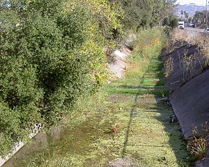
Washington Creek
River in California, United States
Distance: Approx. 3446 meters
Latitude and longitude: 38.24527778,-122.63861111
Washington Creek is a southward-flowing stream in Sonoma County, California, United States which enters the city of Petaluma and discharges to the Petaluma River.

Petaluma Wildlife & Natural Science Museum
Museum in Petaluma, California
Distance: Approx. 3334 meters
Latitude and longitude: 38.22777778,-122.64611111
Petaluma Wildlife & Natural Science Museum is a student-run museum located in the city of Petaluma, California. It is the largest student-run museum in the United States. Its mission is "to inspire the next generation through practical environmental education and conservation." It is a 501(c)3 non-profit organization, relying on donations to fund expenses.

Petaluma North station
Distance: Approx. 3262 meters
Latitude and longitude: 38.267786,-122.655857
Petaluma North station is a planned Sonoma–Marin Area Rail Transit station in Petaluma, California located at Corona Road and North McDowell Boulevard. The station was planned as an infill station to be constructed after the initial phase of the system's construction had been completed. The site may include a 150-space parking facility.

Philip Sweed House
United States historic place
Distance: Approx. 2916 meters
Latitude and longitude: 38.236242,-122.64623
The Philip Sweed House, in Petaluma, California, is a Queen Anne-style house built in 1892. It has sometimes, mistakenly, been reported as the "Philip Swede House." The house is located at the intersection of Keokuk and Prospect Streets. It was listed on the National Register of Historic Places in 1992.

Petaluma Gap AVA
American Viticultural Area
Distance: Approx. 2447 meters
Latitude and longitude: 38.2225,-122.6825
Petaluma Gap is an American Viticultural Area (AVA) established on January 8, 2018 by the Alcohol and Tobacco Tax and Trade Bureau (TTB), Treasury. The area spans 202,476 acres (316 sq mi) stretching through an 30 miles (48 km) inland valley from the Pacific coast at Bodega Bay southeast to Highway 37 at Sears Point on San Pablo Bay straddling the border of northern Marin and southern Sonoma counties. The AVA lies entirely within the North Coast AVA and partially in the Sonoma Coast AVA with eighty commercially-producing vineyards cultivating 4,000 acres (1,619 ha) and nine bonded wineries.
Weather in this IP's area
clear sky
22 Celsius
22 Celsius
19 Celsius
26 Celsius
1010 hPa
51 %
1010 hPa
1007 hPa
10000 meters
4.63 m/s
300 degree
06:56:22
19:12:18