135.131.142.234 - IP Lookup: Free IP Address Lookup, Postal Code Lookup, IP Location Lookup, IP ASN, Public IP
Country:
 USA
USARegion:
City:
Location:
Time Zone:
Postal Code:
ISP:
ASN:
language:
User-Agent:
Proxy IP:
Blacklist:
IP information under different IP Channel
ip-api
Country
Region
City
ASN
Time Zone
ISP
Blacklist
Proxy
Latitude
Longitude
Postal
Route
db-ip
Country
Region
City
ASN
Time Zone
ISP
Blacklist
Proxy
Latitude
Longitude
Postal
Route
IPinfo
Country
Region
City
ASN
Time Zone
ISP
Blacklist
Proxy
Latitude
Longitude
Postal
Route
IP2Location
135.131.142.234Country
usRegion
wisconsin
City
madison
Time Zone
America/Chicago
ISP
Language
User-Agent
Latitude
Longitude
Postal
ipdata
Country
Region
City
ASN
Time Zone
ISP
Blacklist
Proxy
Latitude
Longitude
Postal
Route
Popular places and events near this IP address

Roman Catholic Diocese of Madison
Diocese of the Catholic Church in Wisconsin
Distance: Approx. 2371 meters
Latitude and longitude: 43.05111111,-89.51833333
The Diocese of Madison (Latin: Diœcesis Madisonensis) is a Latin Church diocese in the southwestern part of Wisconsin in the United States. The diocese has approximately 167,000 Catholics in 102 parishes with 98 priests in active ministry. The bishop of Madison is Donald J. Hying.

Capital Brewery
Brewery in Middleton, Wisconsin
Distance: Approx. 2598 meters
Latitude and longitude: 43.094868,-89.516261
Capital Brewery is a brewery in Middleton, Wisconsin. Founded on March 14, 1984, by Ed Janus in Madison, Wisconsin, it is now situated in a former egg processing plant. The company first began production in 1986 and now produces over 20,000 barrels of beer annually.

Vel Phillips Memorial High School
Public high school in Madison, Wisconsin
Distance: Approx. 1245 meters
Latitude and longitude: 43.06374,-89.50079
Vel Phillips Memorial High School (formerly James Madison Memorial High School (JMM) ) or simply "VPM" is a public high school on the west side of Madison, Wisconsin, United States. It was built in 1966 and is part of the Madison Metropolitan School District. It is home to the MMSD Planetarium.

West Towne Mall
Shopping mall in Wisconsin, U.S.
Distance: Approx. 1685 meters
Latitude and longitude: 43.05722222,-89.50583333
West Towne Mall is a shopping mall located in Madison, Wisconsin, U.S., owned by CBL Properties. It was the first enclosed shopping center within 70 miles (110 km) of Madison with its grand opening on October 15, 1970. The mall was designed by the architect Lou Resnick and developed by Jacobs, Visconsi, and Jacobs Co., of Cleveland, Ohio, the developer of Brookfield Square in Milwaukee.
WIBA-FM
Radio station in Sauk City, Wisconsin
Distance: Approx. 2603 meters
Latitude and longitude: 43.056,-89.535
WIBA-FM (101.5 MHz) is a radio station licensed to Sauk City, Wisconsin, United States, serving Madison and south central Wisconsin. The station is owned and operated by iHeartMedia (formerly Clear Channel Communications) and broadcasts a classic rock music format on its primary HD radio, while its HD2 channel carries an oldies format that is simulcast to analog translator station W265CV (100.9 FM).
St. Ambrose Academy
School located in Wisconsin, U.S.A.
Distance: Approx. 1910 meters
Latitude and longitude: 43.05482777,-89.51486212
St. Ambrose Academy is a Roman Catholic elementary school and high school located on the west side of Madison, Wisconsin.

WERN
Public radio station in Madison, Wisconsin
Distance: Approx. 2603 meters
Latitude and longitude: 43.056,-89.535
WERN (88.7 FM) is a non-commercial public radio station in Madison, Wisconsin. It is part of Wisconsin Public Radio (WPR), and is the flagship of WPR's News Network along with AM sister station WHA. The studios are at 821 University Avenue in Madison. WERN is a Class B FM station, with an effective radiated power (ERP) of 20,500 watts.

Herbert and Katherine Jacobs Second House
House in Madison, Wisconsin
Distance: Approx. 1911 meters
Latitude and longitude: 43.07388889,-89.53472222
Herbert and Katherine Jacobs Second House, often called Jacobs II, is a historic house designed by Frank Lloyd Wright and built in 1946–1948 west of Madison, Wisconsin, United States. The house was the second of two that Wright designed for journalist Herbert Jacobs and his wife Katherine. Its design is unusual among Wright's works; he called the style the "Solar Hemicycle" due to its semicircular layout and use of natural materials and orientation to conserve solar energy.
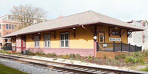
Middleton station
Distance: Approx. 2583 meters
Latitude and longitude: 43.095,-89.51111111
The Middleton Depot is a railway depot built by the Chicago, Milwaukee, St. Paul and Pacific Railroad (also known as The Milwaukee Road) in 1895 in Middleton, Wisconsin. In 1999 it was listed on the National Register of Historic Places.
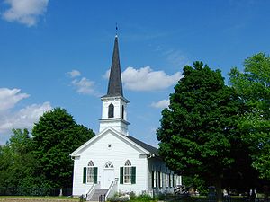
First Lutheran Church (Middleton, Wisconsin)
Historic church in Wisconsin, United States
Distance: Approx. 2092 meters
Latitude and longitude: 43.07523,-89.5367
First Lutheran Church is located in Middleton, Wisconsin, at the corner of Old Sauk Road and Pleasant View Road. The congregation of First Lutheran Church was established in 1852 and this sanctuary was built in 1866 by German immigrants. It has not had an active congregation since 1947.

Holy Name Seminary (Madison, Wisconsin)
United States historic place
Distance: Approx. 2471 meters
Latitude and longitude: 43.051,-89.522
Holy Name Seminary is a former Catholic high school seminary begun in the 1960s on the west side of Madison, Wisconsin. In 2015 the seminary building and some associated structures were added to the National Register of Historic Places as an excellent example of the Neo-Colonial Revival architecture style. The building currently houses offices for the Diocese of Madison as well as an apartment community named Holy Name Heights.

Dr. Newman C. Rowley House
Historic house in Wisconsin, United States
Distance: Approx. 2621 meters
Latitude and longitude: 43.09527778,-89.50888889
The Dr. Newman C. Rowley House is a fine brick house built in 1868 in Middleton, Wisconsin. In 1999 it was listed on the National Register of Historic Places and is now a museum of the Middleton Area Historic Society.
Weather in this IP's area
broken clouds
-5 Celsius
-8 Celsius
-6 Celsius
-4 Celsius
1026 hPa
54 %
1026 hPa
988 hPa
10000 meters
2.06 m/s
75 %