Country:
 USA
USARegion:
City:
Latitude and Longitude:
Time Zone:
Postal Code:
IP information under different IP Channel
ip-api
Country
Region
City
ASN
Time Zone
ISP
Blacklist
Proxy
Latitude
Longitude
Postal
Route
IPinfo
Country
Region
City
ASN
Time Zone
ISP
Blacklist
Proxy
Latitude
Longitude
Postal
Route
MaxMind
Country
Region
City
ASN
Time Zone
ISP
Blacklist
Proxy
Latitude
Longitude
Postal
Route
Luminati
Country
USASN
Time Zone
America/Chicago
Latitude
Longitude
Postal
db-ip
Country
Region
City
ASN
Time Zone
ISP
Blacklist
Proxy
Latitude
Longitude
Postal
Route
ipdata
Country
Region
City
ASN
Time Zone
ISP
Blacklist
Proxy
Latitude
Longitude
Postal
Route
Popular places and events near this IP address
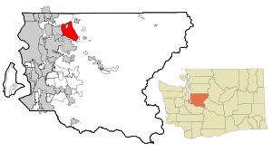
Union Hill-Novelty Hill, Washington
Census-designated place in Washington, United States
Distance: Approx. 1940 meters
Latitude and longitude: 47.67861111,-122.04916667
Union Hill-Novelty Hill is a census-designated place (CDP) in King County, Washington, United States. The area was first recognized by the Census Bureau in the 2000 census. The population was 22,683 at the 2020 census.
The Overlake School
Private school in Redmond, Washington, United States
Distance: Approx. 2638 meters
Latitude and longitude: 47.6938,-122.0702
The Overlake School is a grades 5–12 private, non-sectarian, co-educational, college preparatory school in Redmond, Washington, United States that was founded in 1967 by Charles Clarke.
Redmond High School (Washington)
Public school in Redmond, Washington, United States
Distance: Approx. 5375 meters
Latitude and longitude: 47.69527778,-122.10666667
Redmond High School (RHS) is a four-year public high school located in Redmond, Washington, United States. It is one of four high schools in the Lake Washington School District (LWSD). Opened in 1964, Redmond High School is the second oldest high school in the Lake Washington School District.

The Bear Creek School
Private Christian school in Redmond, Washington, US
Distance: Approx. 2643 meters
Latitude and longitude: 47.681208,-122.065446
The Bear Creek School is a preschool through grade twelve private school in Redmond, Washington. Educating around 840 students, the school is a non-denominational Christian religious school, focusing on college preparation. It was established in 1988.

Evans Creek Preserve
Distance: Approx. 5759 meters
Latitude and longitude: 47.642,-122.046
Evans Creek Preserve is a 179-acre (72 ha) natural area that was donated to the City of Sammamish, Washington, in 2000. The site includes portions of Evans Creek and other water features, wetlands, and meadows, as well as steep terrain. The site provides habitat for black bears, beavers, hawks, deer, and songbirds.

Washington's 45th legislative district
Distance: Approx. 4190 meters
Latitude and longitude: 47.7,-122.09
Washington's 45th legislative district is one of 49 electoral districts in Washington state for representation in the state legislature. It extends from Kirkland on the west, Duvall on the east, and Sammamish on the south. The district's legislators are state senator Manka Dhingra and state representatives Roger Goodman (position 1) and Larry Springer (position 2), all Democrats.

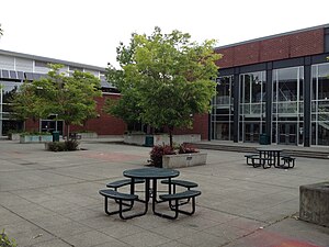
Tesla STEM High School
High school in Redmond, WA
Distance: Approx. 4967 meters
Latitude and longitude: 47.64861111,-122.0375
Tesla STEM High School (officially Nikola Tesla Science, Technology, Engineering & Math High School, formerly STEM High School) is a magnet high school in Redmond, Washington operated by the Lake Washington School District. It serves as a lottery-selected choice program and offers a STEM-based curriculum.

Marymoor Village station
Future light rail station in Redmond, Washington
Distance: Approx. 6259 meters
Latitude and longitude: 47.6674,-122.1092
Marymoor Village station is a future Link light rail station near Marymoor Park in Redmond, Washington. The station is located along the south side of State Route 520 southwest of its interchange with State Route 202 near Downtown Redmond. It also includes a 1,400-stall park and ride in a garage built on the site.
White, Washington
Unincorporated community in Washington, US
Distance: Approx. 4320 meters
Latitude and longitude: 47.7075,-122.08861111
White is an unincorporated community in King County, in the U.S. state of Washington.
East Redmond, Washington
Former town in Washington, United States
Distance: Approx. 3939 meters
Latitude and longitude: 47.68916667,-122.08722222
East Redmond was a short-lived town in King County, Washington that existed from 1956 to 1965. The town, then located to the east of Redmond in the Seattle metropolitan area, was formed as a result of a land use dispute between neighbors. East Redmond, with a population of fewer than 400 people, was found to have not met the state's minimum population requirement for incorporation and was dis-incorporated by a decision of the Washington Supreme Court in 1965.

Vincent School
United States historic place
Distance: Approx. 4760 meters
Latitude and longitude: 47.67388889,-121.97833333
The Vincent School, also known as Vincent Schoolhouse, was an early twentieth century schoolhouse in the rural community of Vincent, near Carnation, Washington, USA. Construction of the school began in 1905 and it was added to the National Register of Historic Places in 2004. The building is currently used as a community center.

William and Estella Adair Farm
Historic place in Carnation, Washington, US
Distance: Approx. 5412 meters
Latitude and longitude: 47.68472222,-121.96388889
The William and Estella Adair Farm, named the Broadacre Farm in 1922, is a 115-acre dairy farm in Carnation, Washington, that illustrates the evolution of a typical dairy farming operation in the Snoqualmie Valley. Established in 1910, it was added to the National Register of Historic Places in 2002.
Weather in this IP's area
overcast clouds
8 Celsius
8 Celsius
6 Celsius
9 Celsius
1024 hPa
85 %
1024 hPa
1002 hPa
10000 meters
0.89 m/s
2.68 m/s
162 degree
100 %
07:32:06
18:13:54