134.6.122.210 - IP Lookup: Free IP Address Lookup, Postal Code Lookup, IP Location Lookup, IP ASN, Public IP
Country:
Region:
City:
Location:
Time Zone:
Postal Code:
IP information under different IP Channel
ip-api
Country
Region
City
ASN
Time Zone
ISP
Blacklist
Proxy
Latitude
Longitude
Postal
Route
Luminati
Country
Region
tx
City
midlothian
ASN
Time Zone
America/Chicago
ISP
GRANITE
Latitude
Longitude
Postal
IPinfo
Country
Region
City
ASN
Time Zone
ISP
Blacklist
Proxy
Latitude
Longitude
Postal
Route
IP2Location
134.6.122.210Country
Region
louisiana
City
baton rouge
Time Zone
America/Chicago
ISP
Language
User-Agent
Latitude
Longitude
Postal
db-ip
Country
Region
City
ASN
Time Zone
ISP
Blacklist
Proxy
Latitude
Longitude
Postal
Route
ipdata
Country
Region
City
ASN
Time Zone
ISP
Blacklist
Proxy
Latitude
Longitude
Postal
Route
Popular places and events near this IP address

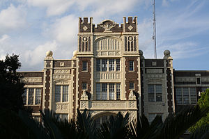
Baton Rouge Magnet High School
Public magnet school in Baton Rouge, Louisiana, United States
Distance: Approx. 775 meters
Latitude and longitude: 30.44531,-91.15967
Baton Rouge Magnet High School (BRMHS or Baton Rouge High) is a public magnet school in Baton Rouge, Louisiana, United States, founded in 1880. It is part of the East Baton Rouge Parish School System with a student body of approximately 1500 students. The current building was built in 1926, and, as Baton Rouge High School, was listed on the National Register of Historic Places in 1986.
Roman Catholic Diocese of Baton Rouge
Diocese of the Catholic Church
Distance: Approx. 1602 meters
Latitude and longitude: 30.45805556,-91.14027778
The Diocese of Baton Rouge (Latin Dioecesis Rubribaculensis; French Diocèse de Bâton-Rouge; Spanish: Diócesis de Baton Rouge), is a Latin Church ecclesiastical territory or diocese in the Florida Parishes region of the U.S. state of Louisiana. It is a suffragan in the ecclesiastical province of the Metropolitan Archdiocese of New Orleans. The current bishop is Michael Duca.

Baton Rouge Community College
Public college in Baton Rouge, Louisiana, US
Distance: Approx. 1849 meters
Latitude and longitude: 30.44888889,-91.13555556
Baton Rouge Community College is a public community college in Baton Rouge, Louisiana. Established on June 28, 1995, the college settled into a permanent location in 1998. The 60-acre (240,000 m2) campus consists of six main buildings: Governors Building, Louisiana Building, Cypress Building, Bienvenue Student Center, the Magnolia Library and Performing Arts Pavilion, and the Bonne Santé Wellness Center.

Baton Rouge National Cemetery
Historic military cemetery in Louisiana, United States
Distance: Approx. 1271 meters
Latitude and longitude: 30.4496296,-91.1678788
Baton Rouge National Cemetery is a United States National Cemetery located in East Baton Rouge Parish, in the city of Baton Rouge, Louisiana. It encompasses 7.7 acres (3.1 ha), and as of 2020, had over 5,000 interments. The cemetery was added to the National Register of Historic Places on July 9, 1997.
Catholic High School (Baton Rouge, Louisiana)
School in Baton Rouge, Louisiana, United States
Distance: Approx. 1121 meters
Latitude and longitude: 30.44083333,-91.15638889
Catholic High School is a private, Catholic college-preparatory day school run by the United States Province of the Brothers of the Sacred Heart in Baton Rouge, Louisiana. It was founded in 1894 as St. Vincent's Academy.
Garden District, Baton Rouge, Louisiana
United States historic place
Distance: Approx. 1618 meters
Latitude and longitude: 30.4399,-91.16585
The Garden District is a residential neighborhood located in Baton Rouge's Mid-City area where Park Boulevard intersects Government Street. The Garden District is an established historic area with many upscale homes and an active civic association [1]. The Garden District is actually a conglomerate of three historic districts as defined by the Louisiana National Register of Historic Places.
St. Joseph's Academy (Baton Rouge)
School in Baton Rouge, , Louisiana, United States
Distance: Approx. 1619 meters
Latitude and longitude: 30.43638889,-91.15694444
St. Joseph's Academy (SJA) is an all-girls Catholic school established in 1868 by the Sisters of St. Joseph of Medaille.

Magnolia Cemetery (Baton Rouge, Louisiana)
Cemetery in Louisiana, US
Distance: Approx. 1232 meters
Latitude and longitude: 30.45101,-91.16754
Magnolia Cemetery is a 10-acre (4.0 ha) cemetery in Baton Rouge, Louisiana.
WHYR-LP
Radio station in Baton Rouge, Louisiana
Distance: Approx. 1526 meters
Latitude and longitude: 30.44972222,-91.17055556
WHYR-LP (96.9 FM) (sometimes pronounced "wire") is a community radio station licensed to Baton Rouge, Louisiana, United States. The station is owned by the Baton Rouge Progressive Network. WHYR-LP airs an eclectic mix of music, from Cajun music and local hip-hop to traditional blues, folk, gospel, and country.
Baton Rouge General Medical Center – Mid-City Campus
Distance: Approx. 221 meters
Latitude and longitude: 30.44938,-91.15309
Baton Rouge General - Mid City, also known as Mid City or The General, is a long term care, not-for-profit, community-owned hospital located in Baton Rouge, Louisiana. This hospital, established in the early 1900s, was the first official hospital to operate in the region. The hospital offers many services, including skilled nursing, wound care, and physical therapy.

Reiley-Reeves House
United States historic place
Distance: Approx. 1779 meters
Latitude and longitude: 30.44089,-91.16924
The Reiley-Reeves House is a historic house located in the Garden District of Baton Rouge, Louisiana, at 810 Park Avenue. It was constructed in c.1910-11 for planter George Junkin Reiley in the Queen Anne Revival style and it is one of the few homes from early 1900s still standing in the city, and it's the only remaining home in the city with a Queen Anne style turret and steeple. The house was listed on the National Register of Historic Places on May 24, 1979.
Capitol High School (Louisiana)
School in Louisiana, US
Distance: Approx. 1298 meters
Latitude and longitude: 30.4591,-91.1642
Capitol High School is a public high school named after the Louisiana State Capitol in Baton Rouge, Louisiana.
Weather in this IP's area
clear sky
16 Celsius
16 Celsius
15 Celsius
17 Celsius
1023 hPa
62 %
1023 hPa
1021 hPa
10000 meters
5.14 m/s
10 degree
