Country:
Region:
City:
Latitude and Longitude:
Time Zone:
Postal Code:
IP information under different IP Channel
ip-api
Country
Region
City
ASN
Time Zone
ISP
Blacklist
Proxy
Latitude
Longitude
Postal
Route
Luminati
Country
Region
ns
City
halifax
ASN
Time Zone
America/Halifax
ISP
CANET-ASN-4
Latitude
Longitude
Postal
IPinfo
Country
Region
City
ASN
Time Zone
ISP
Blacklist
Proxy
Latitude
Longitude
Postal
Route
db-ip
Country
Region
City
ASN
Time Zone
ISP
Blacklist
Proxy
Latitude
Longitude
Postal
Route
ipdata
Country
Region
City
ASN
Time Zone
ISP
Blacklist
Proxy
Latitude
Longitude
Postal
Route
Popular places and events near this IP address

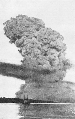
Halifax Explosion
1917 maritime disaster in Halifax, Nova Scotia, Canada
Distance: Approx. 620 meters
Latitude and longitude: 44.66916667,-63.59638889
On the morning of 6 December 1917, the French cargo ship SS Mont-Blanc collided with the Norwegian vessel SS Imo in the harbour of Halifax, Nova Scotia, Canada. Mont-Blanc, laden with high explosives, caught fire and exploded, devastating the Richmond district of Halifax. At least 1,782 people were killed, largely in Halifax and Dartmouth, by the blast, debris, fires, or collapsed buildings, and an estimated 9,000 others were injured.

North End, Halifax
Subdivision in Nova Scotia, Canada
Distance: Approx. 155 meters
Latitude and longitude: 44.66313889,-63.60127778
The North End of Halifax is a neighbourhood of Halifax, Nova Scotia occupying the northern part of Halifax Peninsula immediately north of Downtown Halifax.
CJCH-DT
CTV television station in Halifax, Nova Scotia
Distance: Approx. 630 meters
Latitude and longitude: 44.65863889,-63.60022222
CJCH-DT (channel 5) is a television station in Halifax, Nova Scotia, Canada, part of the CTV Television Network. Owned and operated by network parent Bell Media, the station maintains studios on Robie and Russell Streets in Halifax, and its transmitter is located on Washmill Lake Drive on the city's west side. CJCH-DT is the flagship of the CTV Atlantic regional system, producing all of the system's programming except for some commercials and local news inserts on the other stations.
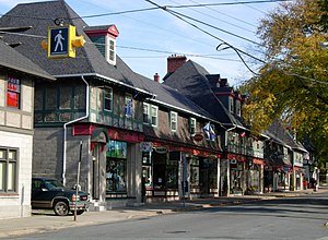
Hydrostone
Neighbourhood in Halifax Regional Municipality, Nova Scotia, Canada
Distance: Approx. 205 meters
Latitude and longitude: 44.66444444,-63.60277778
Hydrostone is a neighbourhood in the North End of the Halifax Peninsula in the Halifax Regional Municipality, Nova Scotia, Canada. It consists of ten short parallel streets and is bordered by Duffus Street to the north, Young Street to the south, Isleville Street to the west and Novalea Drive to the east. The Hydrostone District has about 9.3 ha (23 acres) of landmass.
Richmond, Nova Scotia
Former development in Halifax, Nova Scotia
Distance: Approx. 287 meters
Latitude and longitude: 44.66658333,-63.59852778
Richmond was a Canadian urban community occupying the northern extremity of the peninsular City of Halifax. (Now part of the Halifax Regional Municipality.) It was the epicentre of the Halifax Explosion of 6 December 1917, the worst disaster in Canadian history, in which as many as 2000 people died and thousands more were injured. From the 1770s Richmond was home to Fort Needham, and in 1819 Richmond Grove (lower Duffus Street) was the site of the famous fatal duel between Richard John Uniacke Jr and William Bowie.

Halifax Needham
Provincial electoral district in Nova Scotia, Canada
Distance: Approx. 123 meters
Latitude and longitude: 44.6632,-63.6
Halifax Needham is a provincial electoral district in Halifax, Nova Scotia, Canada, that elects one member of the Nova Scotia House of Assembly. It has existed since 1967, though its boundaries have changed periodically. Halifax Needham encompasses what is largely known as the North End of Halifax.

Shambhala School
Private school in Halifax, Nova Scotia, Canada
Distance: Approx. 418 meters
Latitude and longitude: 44.661617,-63.596512
The Shambhala School is a non-denominational private school in Halifax, Nova Scotia based on Shambhala Buddhist principles. It employs a creative curriculum, integrating both academics and art. It runs from pre-primary through grade 12.

CJCH-FM
Radio station in Halifax, Nova Scotia
Distance: Approx. 554 meters
Latitude and longitude: 44.65933333,-63.59966667
CJCH-FM (101.3 MHz) is a commercial radio station in Halifax, Nova Scotia, Canada. The station broadcasts a Top 40/CHR format branded on-air as 101.3 Virgin Radio, and is owned by Bell Media. CJCH's studios and offices are located at the intersection of Russell and Agricola streets in Halifax (behind TV sister station CJCH-DT).

Veith House
Place in Nova Scotia, Canada
Distance: Approx. 371 meters
Latitude and longitude: 44.66472222,-63.59555556
Veith House is an organization whose mission is to meet the needs of children, individuals and families, with empowerment as an ever-present goal. It is located at 3115 Veith St in the North End of the Halifax Regional Municipality, Nova Scotia, Canada. It is just down the hill from one of Halifax's landmarks, The Hydrostone.

SS Mont-Blanc
French cargo ship
Distance: Approx. 551 meters
Latitude and longitude: 44.6688,-63.5973
SS Mont-Blanc was a cargo steamship that was built in Middlesbrough, England in 1899 for a French shipping company. On Thursday morning, December 6, 1917, she entered Halifax Harbour in Nova Scotia, Canada laden with a full cargo of highly volatile explosives. As she made her way through the Narrows towards Bedford Basin, she was involved in a collision with Imo, a Norwegian ship.
Mulgrave Park
Neighbourhood in Halifax Regional Municipality, Nova Scotia, Canada
Distance: Approx. 472 meters
Latitude and longitude: 44.6685,-63.601
Mulgrave Park is a residential neighbourhood in North End Halifax, Nova Scotia. It consists of local public housing along Barrington Street. It is also referred to as MGP by most residents.
Nova Scotia Cotton Manufacturing Company
Cotton mill in Halifax explosion
Distance: Approx. 721 meters
Latitude and longitude: 44.65783333,-63.60066667
The Nova Scotia Cotton Manufacturing Company was a cotton mill located in Halifax, Nova Scotia which was founded in 1882 and destroyed with great loss of life by the Halifax Explosion in 1917. The company was formed as part of an effort to industrialize the Maritime provinces of Canada and switch from merchant shipping to manufacturing under Canada's National Policy. Typical of the regional enthusiasm for industry in the 1880s, the company was quickly capitalized by 32 local investors within two weeks, drawn from a who's who of Halifax manufacturers, merchants and business leaders including railway engineer Sandford Fleming.
Weather in this IP's area
clear sky
5 Celsius
1 Celsius
4 Celsius
6 Celsius
1011 hPa
79 %
1011 hPa
1006 hPa
10000 meters
4.47 m/s
310 degree
5 %
07:00:56
16:55:19
