134.244.160.43 - IP Lookup: Free IP Address Lookup, Postal Code Lookup, IP Location Lookup, IP ASN, Public IP
Country:
Region:
City:
Location:
Time Zone:
Postal Code:
IP information under different IP Channel
ip-api
Country
Region
City
ASN
Time Zone
ISP
Blacklist
Proxy
Latitude
Longitude
Postal
Route
Luminati
Country
ASN
Time Zone
America/Chicago
ISP
SIEMENS-PLM
Latitude
Longitude
Postal
IPinfo
Country
Region
City
ASN
Time Zone
ISP
Blacklist
Proxy
Latitude
Longitude
Postal
Route
IP2Location
134.244.160.43Country
Region
new jersey
City
iselin
Time Zone
America/New_York
ISP
Language
User-Agent
Latitude
Longitude
Postal
db-ip
Country
Region
City
ASN
Time Zone
ISP
Blacklist
Proxy
Latitude
Longitude
Postal
Route
ipdata
Country
Region
City
ASN
Time Zone
ISP
Blacklist
Proxy
Latitude
Longitude
Postal
Route
Popular places and events near this IP address

Colonia, New Jersey
Place in Middlesex County, New Jersey, United States
Distance: Approx. 2505 meters
Latitude and longitude: 40.594133,-74.31377
Colonia is an unincorporated community and census-designated place (CDP) in Woodbridge Township, Middlesex County, New Jersey, United States. As of the 2020 United States census, the CDP's population was 18,609.

Iselin, New Jersey
Populated place in Middlesex County, New Jersey, US
Distance: Approx. 419 meters
Latitude and longitude: 40.569295,-74.321106
Iselin () is an unincorporated community and census-designated place (CDP) located within Woodbridge Township, in Middlesex County, in the U.S. state of New Jersey. As of the 2020 United States census, Iselin's population was 20,088, up from 18,695 in 2010. Previously known as "Perrytown" and "Unionville", Iselin received its current name after New York City investment banker and philanthropist Adrian Iselin, who established a finishing school in the 1870s for girls from wealthy New York families there.
Menlo Park, New Jersey
Populated place in Middlesex County, New Jersey, US
Distance: Approx. 1861 meters
Latitude and longitude: 40.565,-74.3375
Menlo Park is an unincorporated community within Edison Township in Middlesex County, in the U.S. state of New Jersey. In 1876, Thomas Edison set up his home and research laboratory in Menlo Park, at the time an unsuccessful real estate development named after the town of Menlo Park, California. In this lab, which was one of the first to pursue practical, commercial applications of research, Edison invented the phonograph and developed a commercially viable incandescent light bulb filament.

Metropark station
NJ Transit and Amtrak station
Distance: Approx. 1127 meters
Latitude and longitude: 40.5681,-74.3298
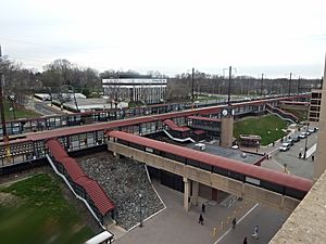
Metropark station is an intermodal transportation hub on the Northeast Corridor in the Iselin section of Woodbridge Township in Middlesex County, New Jersey that is located 24.6 miles southwest of New York Penn Station. It is owned and operated by NJ Transit and serves Amtrak and NJ Transit's Northeast Corridor Line. NJ Transit runs peak period 'loop' buses in coordination with train schedules.
Menlo Park Terrace, New Jersey
Populated place in Middlesex County, New Jersey, US
Distance: Approx. 2134 meters
Latitude and longitude: 40.55333333,-74.32416667
Menlo Park Terrace is an unincorporated community and census-designated place (CDP) in Woodbridge Township, Middlesex County, New Jersey, United States. As of the 2020 census, its population was 2,806.

Thomas Alva Edison Memorial Tower and Museum
United States historic place
Distance: Approx. 2103 meters
Latitude and longitude: 40.56305556,-74.33944444
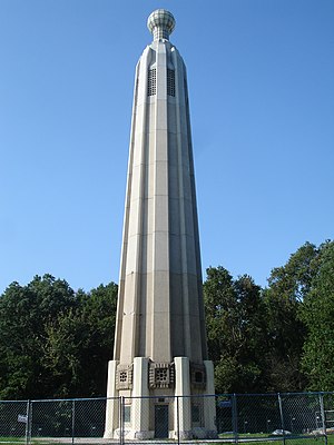
The Thomas Edison Center at Menlo Park, also known as the Menlo Park Museum / Edison Memorial Tower, is a memorial to inventor and businessman Thomas Alva Edison, located in the Menlo Park area of Edison, Middlesex County, New Jersey. The tower was dedicated on February 11, 1938, on what would have been the inventor's 91st birthday. The tower marks the location of Edison's Menlo Park laboratory, the world's first organized research and development site.

Roosevelt Park (Edison, New Jersey)
Distance: Approx. 2571 meters
Latitude and longitude: 40.555108,-74.338409
Roosevelt Park is a 217-acre park located in central east Edison, New Jersey, at Parsonage Road and U.S. Route 1, just west of Menlo Park Mall. Established in 1933 in what was then Raritan Township, the park is considered the oldest park in the Middlesex County Park System. It is owned and operated by the county government.
Colonia High School
High school in Middlesex County, New Jersey, US
Distance: Approx. 2261 meters
Latitude and longitude: 40.59194444,-74.32083333
Colonia High School is a four-year comprehensive public high school that serves students in ninth through twelfth grades in the Colonia section of Woodbridge Township in Middlesex County, in the U.S. state of New Jersey. It operates as part of the Woodbridge Township School District, along with two other high schools, John F. Kennedy Memorial High School and Woodbridge High School. The school has been accredited by the Middle States Association of Colleges and Schools Commission on Elementary and Secondary Schools since 1973; In Fall 2018, the school's accreditation status was extended for seven years, through July 2026.
John F. Kennedy Memorial High School (New Jersey)
High school in Middlesex County, New Jersey, US
Distance: Approx. 960 meters
Latitude and longitude: 40.57311,-74.306177
John F. Kennedy Memorial High School (J.F.K.) is one of three four-year comprehensive public high schools that serve students in ninth through twelfth grades from Woodbridge Township in Middlesex County, in the U.S. state of New Jersey, operating as part of the Woodbridge Township School District. The other two high schools in the district are Colonia High School and Woodbridge High School. The school has been accredited by the Middle States Association of Colleges and Schools Commission on Elementary and Secondary Schools since 1968 and expires in July 2026; In Fall 2018, the school's accreditation status was extended for seven years.

Woodbridge Center
Shopping mall in Middlesex County, New Jersey, US
Distance: Approx. 2281 meters
Latitude and longitude: 40.556666,-74.299213
Woodbridge Center is a major two-level shopping mall located in Woodbridge Township, in the U.S. state of New Jersey, at the intersection of U.S. Route 1 and U.S. Route 9. As of 2022, the mall features Macy's, Boscov's, JCPenney, and Dick's Sporting Goods. The land that Woodbridge Center now stands on used to be the location of Maple Hill Dairy farm and old clay pits.

Edison State Park
State park in New Jersey, United States
Distance: Approx. 2485 meters
Latitude and longitude: 40.55805556,-74.34055556
The Edison State Park is located in the Menlo Park section of Edison, New Jersey. It is located on Christie Street, the first street in the world to be lit up by lightbulb, just off Lincoln Highway, near the Metropark Train Station. It covers a total area of 37 acres (0.15 km2).
Little India (Middlesex County, New Jersey)
South Asian shopping district in Edison, New Jersey
Distance: Approx. 799 meters
Latitude and longitude: 40.57393,-74.32642
Oak Tree Road is a predominantly South Asian shopping, business, and dining district centered on a road designated County Route 604 in Middlesex County, in Central New Jersey. The district, which has been called "Little India," is set amidst a suburban residential area that is home to many South Asian families.
Weather in this IP's area
scattered clouds
6 Celsius
1 Celsius
5 Celsius
7 Celsius
1006 hPa
66 %
1006 hPa
1004 hPa
10000 meters
10.8 m/s
17.49 m/s
280 degree
40 %