134.215.104.120 - IP Lookup: Free IP Address Lookup, Postal Code Lookup, IP Location Lookup, IP ASN, Public IP
Country:
 USA
USARegion:
City:
Location:
Time Zone:
Postal Code:
ISP:
ASN:
language:
User-Agent:
Proxy IP:
Blacklist:
IP information under different IP Channel
ip-api
Country
Region
City
ASN
Time Zone
ISP
Blacklist
Proxy
Latitude
Longitude
Postal
Route
db-ip
Country
Region
City
ASN
Time Zone
ISP
Blacklist
Proxy
Latitude
Longitude
Postal
Route
IPinfo
Country
Region
City
ASN
Time Zone
ISP
Blacklist
Proxy
Latitude
Longitude
Postal
Route
IP2Location
134.215.104.120Country
usRegion
oregon
City
redmond
Time Zone
America/Los_Angeles
ISP
Language
User-Agent
Latitude
Longitude
Postal
ipdata
Country
Region
City
ASN
Time Zone
ISP
Blacklist
Proxy
Latitude
Longitude
Postal
Route
Popular places and events near this IP address
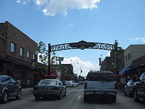
Redmond, Oregon
City in Oregon, United States
Distance: Approx. 11 meters
Latitude and longitude: 44.2725,-121.17388889
Redmond is a city in Deschutes County, Oregon, United States. The population was 33,274 at the 2020 census, and according to 2023 census estimates, the city is estimated to have a population of 37,009. The city is on the eastern side of Oregon's Cascade Range, in the High Desert in Central Oregon.

Hooker Creek Events Center
Distance: Approx. 4193 meters
Latitude and longitude: 44.2355,-121.183
The Hooker Creek Events Center is a 7,500-seat multi-purpose arena in Redmond, Oregon, United States. The largest of several buildings on the Deschutes County Expo Center, it hosts sporting events and concerts. It opened in 2000.

Redmond High School (Oregon)
Public school in Redmond, Oregon, United States
Distance: Approx. 1339 meters
Latitude and longitude: 44.2714,-121.19061
Redmond High School (RHS) is a public high school in Redmond, Oregon, United States.

Roberts Field
Airport in Redmond serving Central Oregon, United States
Distance: Approx. 2815 meters
Latitude and longitude: 44.25416667,-121.14972222
Redmond Municipal Airport (IATA: RDM, ICAO: KRDM, FAA LID: RDM) (Roberts Field) is in Deschutes County, Oregon, United States. It is owned and operated by the city of Redmond, Oregon. It is the main commercial airport in Central Oregon, with nonstop scheduled passenger airline flights to several hubs in the western U.S. as well as seasonally to Dallas.
KRDM
Radio station in Redmond, Oregon
Distance: Approx. 2339 meters
Latitude and longitude: 44.27805556,-121.14555556
KRDM (1240 AM, "La Bronca") is a commercial regional Mexican radio station in Bend, Oregon. The station first went on air in 2004 broadcasting a news/talk format. Legendary Central Oregon radio host Bobby Smith was the only live and local air talent on the station.

Central Christian Schools
Private school in Redmond, Deschutes County, Oregon, United States
Distance: Approx. 2059 meters
Latitude and longitude: 44.255806,-121.163082
Central Christian Schools is a private Christian school in Redmond, Oregon, United States. The school has been accredited through the Association of Christian Schools International since 1992, and through the Northwest Accreditation Commission since 2002. The Central Christian Tigers compete in the OSAA Mountain Valley 1A league.

New Redmond Hotel
United States historic place
Distance: Approx. 67 meters
Latitude and longitude: 44.27228,-121.17461
The New Redmond Hotel is a historic commercial hotel in Redmond, Oregon, United States. The hotel was built in 1928 after the original Redmond Hotel, (sometimes referred to as "Hotel Redmond") was destroyed in a fire. It is a three-story Georgian-style brick masonry building located on 6th Street in downtown Redmond.

Milton Odem House
United States historic place
Distance: Approx. 591 meters
Latitude and longitude: 44.27113,-121.18102
The Milton Odem House is a small bungalow home located in Redmond, Oregon. The house was built in 1937 by Ole K. Olson for Milton Odem, a local theater owner. It is one of the best examples of residential Streamline Moderne architecture in Oregon.

Edwin Brown High School
Public school in Redmond, Deschutes County, Oregon, United States
Distance: Approx. 485 meters
Latitude and longitude: 44.276276,-121.177163
Edwin Brown High School, also known as Edwin Brown Alternative High School, was an alternative high school in Redmond, Oregon, United States. It merged into Redmond High School in late 2009.

First Presbyterian Church of Redmond
Historic church in Oregon, United States
Distance: Approx. 258 meters
Latitude and longitude: 44.27474,-121.17513
Built in 1912, the First Presbyterian Church of Redmond is the oldest standing church structure in the city of Redmond, Oregon, United States. It is also the second-oldest religious building in Deschutes County. The church was built in the Gothic Revival style with Queen Anne architectural detailing.
St. Charles Medical Center – Redmond
Hospital in Oregon, United States
Distance: Approx. 1739 meters
Latitude and longitude: 44.288,-121.1702
St. Charles Medical Center – Redmond is a hospital in Redmond, Oregon, United States. It is a level 3 trauma center.

General Duffy's Waterhole
Taphouse and event venue in Redmond, Oregon, US
Distance: Approx. 184 meters
Latitude and longitude: 44.27137,-121.17236
General Duffy's Waterhole is a beer and cider taphouse with a food court and two large events venues located in Redmond, Oregon. It opened for business in 2019. Shortly after opening, Duffy's began hosting weekly street markets next to the taphouse.
Weather in this IP's area
clear sky
1 Celsius
-4 Celsius
-0 Celsius
2 Celsius
1022 hPa
57 %
1022 hPa
910 hPa
10000 meters
4.63 m/s
310 degree