Country:
 USA
USARegion:
City:
Latitude and Longitude:
Time Zone:
Postal Code:
IP information under different IP Channel
ip-api
Country
Region
City
ASN
Time Zone
ISP
Blacklist
Proxy
Latitude
Longitude
Postal
Route
IPinfo
Country
Region
City
ASN
Time Zone
ISP
Blacklist
Proxy
Latitude
Longitude
Postal
Route
MaxMind
Country
Region
City
ASN
Time Zone
ISP
Blacklist
Proxy
Latitude
Longitude
Postal
Route
Luminati
Country
USRegion
nj
City
northbergen
ASN
Time Zone
America/New_York
ISP
DIGITALOCEAN-ASN
Latitude
Longitude
Postal
db-ip
Country
Region
City
ASN
Time Zone
ISP
Blacklist
Proxy
Latitude
Longitude
Postal
Route
ipdata
Country
Region
City
ASN
Time Zone
ISP
Blacklist
Proxy
Latitude
Longitude
Postal
Route
Popular places and events near this IP address
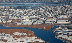
North Bergen, New Jersey
Township in Hudson County, New Jersey, US
Distance: Approx. 131 meters
Latitude and longitude: 40.794163,-74.024947
North Bergen is a township in the northern part of Hudson County, in the U.S. state of New Jersey. As of the 2020 United States census, the township's population was 63,361, an increase of 2,588 (+4.3%) from the 2010 census count of 60,773, which in turn reflected an increase of 2,681 (+4.6%) from the 58,092 counted in the 2000 census. The township was incorporated in 1843.
Flower Hill Cemetery (North Bergen, New Jersey)
Distance: Approx. 540 meters
Latitude and longitude: 40.788157,-74.02514
Flower Hill Cemetery is located in North Bergen, New Jersey. It is cojoined with Hoboken Cemetery and Machpelah Cemetery.
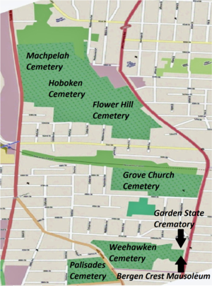
Hoboken Cemetery
Distance: Approx. 540 meters
Latitude and longitude: 40.788157,-74.02514
The Hoboken Cemetery is located at 5500 Tonnelle Avenue in North Bergen, New Jersey, United States. in the New Durham section. It was owned by the City of Hoboken.
Union Township, Hudson County, New Jersey
Distance: Approx. 1104 meters
Latitude and longitude: 40.7884,-74.0131
Union Township was a township that existed in Hudson County, New Jersey, United States. The township existed from 1861 to 1898. Union Township ("Town of Union") was incorporated as a township by an Act of the New Jersey Legislature on February 28, 1861, from portions of North Bergen Township.

Tonnelle Avenue station
Light rail station in New Jersey, US
Distance: Approx. 835 meters
Latitude and longitude: 40.787327,-74.03119
Tonnelle Avenue station is a ground-level station on the Hudson–Bergen Light Rail (HBLR) located at 51st Street in North Bergen, New Jersey. The station opened for service on February 25, 2006. Service from the station travels to West Side Avenue in Jersey City at all times.
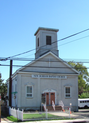
New Durham, North Bergen
Populated place in Hudson County, New Jersey, US
Distance: Approx. 1160 meters
Latitude and longitude: 40.78472222,-74.03305556
New Durham is a neighborhood in North Bergen Township in Hudson County, in the U.S. state of New Jersey. It is located near the foot of Union Turnpike and Bergen Turnpike, and south of the Tonnelle Avenue Station of the Hudson Bergen Light Rail. It is one of the few residential areas along the otherwise industrial/commercial Tonnelle Ave, and site of one of the town's main post offices.

Grove Church Cemetery
Cemetery in Hudson County, New Jersey, US
Distance: Approx. 1101 meters
Latitude and longitude: 40.7831566,-74.0259734
The Grove Church Cemetery is a nonsectarian cemetery, located on the western slope of the Hudson Palisades, along with several other cemeteries in a string of green open space, in Hudson County, New Jersey, United States. The Grove Church, who owns the cemetery, is one of the oldest religious bodies in the area, and it has had an operating cemetery since 1847. Throughout its history, prominent families have been buried there, as well as American Civil war veterans.

Machpelah Cemetery (North Bergen, New Jersey)
Cemetery in New Jersey, US
Distance: Approx. 540 meters
Latitude and longitude: 40.7881566,-74.0251401
The Machpelah Cemetery, also spelled as "Macpelah Cemetery", or "Macphelah Cemetery", is a cemetery in Hudson County, New Jersey.

Maisland
Populated place in Hudson County, New Jersey, US
Distance: Approx. 819 meters
Latitude and longitude: 40.78718,-74.03065
Maisland, or Mais Land, was an area in Hudson County, New Jersey.
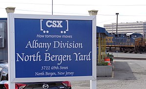
North Bergen Yard
Distance: Approx. 447 meters
Latitude and longitude: 40.793,-74.03
The North Bergen Yard is freight rail yard and intermodal terminal in North Bergen, New Jersey parallel to Tonnelle Avenue between 49th and 69th Streets. Located within the North Jersey Shared Assets Area, the facility is part of CSX Transportation (CSXT) and the origination point of its CSX River Subdivision at the southern end of the Albany Division. On its west side, the New York, Susquehanna and Western Railway (NYSW) runs the length of the yard and operates a bulk transloading operation immediately adjacent to it.
69th Street station (NJ Transit)
Distance: Approx. 1003 meters
Latitude and longitude: 40.801873,-74.026798
69th Street is a proposed interchange station in North Bergen in Hudson County, New Jersey. It would serve passengers on two lines under consideration by NJ Transit, the Passaic–Bergen–Hudson Transit Project and the Northern Branch Corridor Project, the latter of which is an extension of the Hudson–Bergen Light Rail. The station would located at-grade west the North Bergen Yard and Tonnelle Avenue.
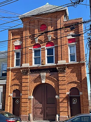
Excelsior Engine Co. No. 2 Firehouse
United States historic place
Distance: Approx. 661 meters
Latitude and longitude: 40.79102778,-74.01730556
The Excelsior Engine Co. No. 2 Firehouse is a historic former fire station built in 1897 and located at 6106 Polk Street in the town of West New York in Hudson County, New Jersey, United States.
Weather in this IP's area
clear sky
12 Celsius
12 Celsius
10 Celsius
14 Celsius
1014 hPa
80 %
1014 hPa
1007 hPa
10000 meters
4.63 m/s
300 degree
06:30:28
19:17:07