Country:
Region:
City:
Latitude and Longitude:
Time Zone:
Postal Code:
IP information under different IP Channel
ip-api
Country
Region
City
ASN
Time Zone
ISP
Blacklist
Proxy
Latitude
Longitude
Postal
Route
Luminati
Country
ASN
Time Zone
Asia/Hong_Kong
ISP
Telstra Global
Latitude
Longitude
Postal
IPinfo
Country
Region
City
ASN
Time Zone
ISP
Blacklist
Proxy
Latitude
Longitude
Postal
Route
db-ip
Country
Region
City
ASN
Time Zone
ISP
Blacklist
Proxy
Latitude
Longitude
Postal
Route
ipdata
Country
Region
City
ASN
Time Zone
ISP
Blacklist
Proxy
Latitude
Longitude
Postal
Route
Popular places and events near this IP address

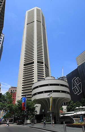
25 Martin Place
Skyscraper in Sydney, Australia
Distance: Approx. 92 meters
Latitude and longitude: -33.868019,151.209324
25 Martin Place (formerly and still commonly known as the MLC Centre) is a skyscraper in Sydney, Australia. Originally named the "MLC Centre" after MLC Limited, and still commonly referred to by that name, in 2021 the name was removed by its owner, Dexus, which now refers to the building simply by its street address of 25 Martin Place.

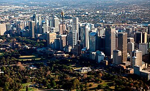
Sydney central business district
Suburb of Sydney, New South Wales, Australia
Distance: Approx. 62 meters
Latitude and longitude: -33.86888889,151.20833333
The Sydney central business district (CBD) is the historical and main commercial centre of Sydney. The CBD is Sydney's city centre, or Sydney City, and the two terms are used interchangeably. Colloquially, the CBD or city centre is often referred to simply as "Town" or "the City".

Rowe Street, Sydney
Street in Sydney, Australia
Distance: Approx. 87 meters
Latitude and longitude: -33.8682,151.2084
Rowe Street is a narrow laneway in the central business district of Sydney in New South Wales, Australia. Originally, Rowe Street ran between Castlereagh Street and Pitt Street, parallel to Martin Place. However, it now runs east–west off Pitt Street.
Australian Institute of Company Directors
Distance: Approx. 62 meters
Latitude and longitude: -33.868989,151.209631
The Australian Institute of Company Directors (AICD) is a non-profit membership organization for directors. The AICD is a founding member of the Global Network of Director Institutes (GNDI).

Theatre Royal Sydney
Theatre in Sydney, Australia
Distance: Approx. 91 meters
Latitude and longitude: -33.868,151.2088
Theatre Royal Sydney (TRS) is a theatre in Sydney, Australia. Earlier theatres also called the Theatre Royal, on the same site, date back to 1833. The current building, designed by modernist architect Harry Seidler, was built in 1976 and has offered a broad range of entertainment since the 1990s.
Soul Pattinson Building
Building in Sydney, Australia
Distance: Approx. 94 meters
Latitude and longitude: -33.8694874,151.2084154
The Soul Pattinson Building is a Victorian Italianate retail and office building located at 158–160 Pitt Street, Sydney, Australia. The Soul Pattinson Building is located between the Pitt Street Mall and Castlereagh Street, and opposite the Strand Arcade.

Glasshouse (Sydney)
Shopping mall in New South Wales, Australia
Distance: Approx. 35 meters
Latitude and longitude: -33.869099,151.208886
Glasshouse (previously known as Stockland Glasshouse, Glasshouse Shopping Centre and Glasshouse on the Mall) is an office and retail building in the Sydney central business district. It is located on the corner of King Street and Pitt Street Mall, adjacent to Westfield Sydney and is opposite MidCity, The Strand Arcade and Sydney Arcade. Glasshouse is a 25 floor office complex with retail on the floors below.

Kings Hotel, Sydney CBD
Heritage-listed pub in Sydney, Australia
Distance: Approx. 46 meters
Latitude and longitude: -33.8688,151.2085
Kings Hotel is a heritage-listed former pub and now commercial premises located at 138–140 Pitt Street, in the Sydney central business district, in the City of Sydney local government area of New South Wales, Australia. It was built from 1879. It is also known as Trickett's Hotel and Sugar House.

The Sydney Club
Heritage-listed building in Sydney, Australia
Distance: Approx. 67 meters
Latitude and longitude: -33.8683,151.2086
The Sydney Club is a heritage-listed club premises at 122 Pitt Street, in the Sydney central business district, in the City of Sydney local government area of New South Wales, Australia. It was designed by Mansfield Brothers and built from 1886 to 1887 by A & A Scott. It is also known as Million House.

Grahame's Corner
Heritage-listed building in Sydney, Australia
Distance: Approx. 57 meters
Latitude and longitude: -33.8691,151.2085
Grahame's Corner is a heritage-listed commercial and office building located at 142-144 Pitt Street, in the Sydney central business district, in the City of Sydney local government area of New South Wales, Australia. It was designed by G. A. Morell and built from 1877 to 1882. It is also known as Grahams Corner and the AMFIS Building.

Trust Building
Building in Sydney, Australia
Distance: Approx. 100 meters
Latitude and longitude: -33.8693,151.2099
The Trust Building is a heritage-listed office and commercial building and former hotel located at 72-72a Castlereagh Street, in the Sydney central business district, in the City of Sydney local government area of New South Wales, Australia. It was designed by firm Robertson & Marks and built from 1914 to 1916 by Stuart Brothers. It was added to the New South Wales State Heritage Register on 2 April 1999.

Culwulla Chambers
Commercial in Sydney, Australia
Distance: Approx. 44 meters
Latitude and longitude: -33.86916667,151.20916667
The Culwulla Chambers is a heritage listed building located at 67 Castlereagh Street in Sydney, Australia. Its situated in the Central Business District of Sydney. The building is colloquially named as Sydney's first skyscraper, though it is of masonry construction rather than steel frame typically associated with the term.
Weather in this IP's area
broken clouds
19 Celsius
19 Celsius
19 Celsius
20 Celsius
1017 hPa
79 %
1017 hPa
1009 hPa
10000 meters
1.79 m/s
7.15 m/s
5 degree
75 %
05:51:04
19:26:25
