Country:
Region:
City:
Latitude and Longitude:
Time Zone:
Postal Code:
IP information under different IP Channel
ip-api
Country
Region
City
ASN
Time Zone
ISP
Blacklist
Proxy
Latitude
Longitude
Postal
Route
Luminati
Country
Region
23
City
nagoya
ASN
Time Zone
Asia/Tokyo
ISP
Research Organization of Information and Systems, National Institute of Informatics
Latitude
Longitude
Postal
IPinfo
Country
Region
City
ASN
Time Zone
ISP
Blacklist
Proxy
Latitude
Longitude
Postal
Route
db-ip
Country
Region
City
ASN
Time Zone
ISP
Blacklist
Proxy
Latitude
Longitude
Postal
Route
ipdata
Country
Region
City
ASN
Time Zone
ISP
Blacklist
Proxy
Latitude
Longitude
Postal
Route
Popular places and events near this IP address

Nagoya
Designated city in Chūbu, Japan
Distance: Approx. 735 meters
Latitude and longitude: 35.18333333,136.9
Nagoya (名古屋市, Nagoya-shi, [naꜜɡoja] ) is the largest city in the Chūbu region of Japan. It is the fourth-most populous city in Japan, with a population of 2.3 million in 2020, and the principal city of the Chūkyō metropolitan area, which is the third-most populous metropolitan area in Japan with a population of 10.11 million. Located on the Pacific coast in central Honshu, it is the capital and most populous city of Aichi Prefecture, with the Port of Nagoya being Japan's largest seaport.

Nagoya Castle
Japanese castle located in Nagoya, central Japan
Distance: Approx. 846 meters
Latitude and longitude: 35.18555556,136.89861111
Nagoya Castle (名古屋城, Nagoya-jō) is a Japanese castle located in Nagoya, Japan. Nagoya Castle was constructed by the Owari Domain in 1612 during the Edo period on the site of an earlier castle of the Oda clan in the Sengoku period. Nagoya Castle was the heart of one of the most important castle towns in Japan, Nagoya-juku, a post station on the Minoji road linking two of the important Edo Five Routes, the Tōkaidō and the Nakasendō.

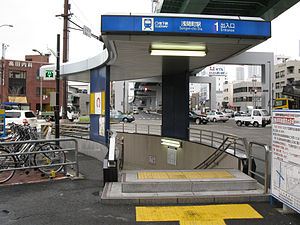
Sengen-chō Station
Metro station in Nagoya, Japan
Distance: Approx. 651 meters
Latitude and longitude: 35.184,136.8902
Sengen-chō Station (浅間町駅, Sengen-chō-eki) is a railway station in Nishi-ku, Nagoya, Aichi Prefecture, Japan.

Marunouchi Station (Nagoya)
Metro station in Nagoya, Japan
Distance: Approx. 694 meters
Latitude and longitude: 35.1733,136.897
Marunouchi Station (丸の内駅, Marunouchi-eki) is an underground metro station located in Naka-ku, Nagoya, Aichi Prefecture, Japan operated by the Nagoya Municipal Subway. The station is an interchange station between the Tsurumai Line and the Sakura-dōri Line, and is located 6.3 rail kilometers from the terminus of the Tsurumai Line at Kami-Otai Station and 2.4 rail kilometers from the terminus of the Sakuradōri Line at Nakamura Kuyakusho Station. This station provides access to Aichi Prefectural Library, the headquarters of Chunichi Shimbun, the Brazilian consulate in Nagoya, and the Nagoya branch offices of various companies.

Kokusai Center Station
Metro station in Nagoya, Japan
Distance: Approx. 871 meters
Latitude and longitude: 35.1721,136.8894
Kokusai Center Station (国際センター駅, Kokusai Sentaa-eki) is a train station in Nakamura-ku, Nagoya, Aichi Prefecture, Japan. The station is linked to Nagoya International Center, after which the station is named. A long underground passage links this station directly to Nagoya Station; that is, the network of underground shopping malls and passages extends to this station and includes it.
Shikemichi
Distance: Approx. 463 meters
Latitude and longitude: 35.175,136.8925
Shike-michi (四間道) is a small historical street in Nishi-ku, Nagoya in central Japan.
Nagoya Shrine
Shinto shrine in Japan
Distance: Approx. 555 meters
Latitude and longitude: 35.1775,136.89972222
The Nagoya Shrine (那古野神社, Nagoya-jinja) is a Shinto shrine located in Marunouchi in the Naka Ward in Nagoya, central Japan.
Aichi Gokoku Shrine
Shinto shrine in Nagoya, Japan
Distance: Approx. 531 meters
Latitude and longitude: 35.17944444,136.89972222
The Aichi Prefecture Gokoku Shrine is a Shinto shrine located in the Sannomaru compound, next to Nagoya Castle, in central Nagoya, Japan.

Nagoya Tōshō-gū
Distance: Approx. 517 meters
Latitude and longitude: 35.17755556,136.89930556
Nagoya Tōshō-gū (名古屋東照宮) is a Shinto shrine located in central Nagoya, Aichi Prefecture, Japan.
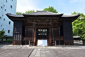
Fuji Sengen Shrine (Nishi-ku, Nagoya)
Distance: Approx. 185 meters
Latitude and longitude: 35.1805185,136.8947367
The Fuji Sengen Shrine (富士浅間神社, Fuji Sengen Jinja) is a Shinto shrine located at the historic Shikemichi in Nishi-ku, Nagoya, central Japan. The shrine is dedicated to the goddess Ko-no-hana-no-saku-ya hime.

Honkō-ji
Buddhist temple in Aichi Prefecture, Japan
Distance: Approx. 812 meters
Latitude and longitude: 35.18472222,136.89944444
Honkō-ji (本光寺) is a Buddhist temple belonging to the Sōtō sect of Japanese Zen located in the town of Kōta, Nukata District, Aichi Prefecture, Japan. The temple is noted for its hydrangea flowers in spring. Its main image is a statue of Shaka Nyōrai.

Consulate of the United States, Nagoya
Architectural structure
Distance: Approx. 765 meters
Latitude and longitude: 35.17280556,136.89027778
The Consulate of the United States, Nagoya (Japanese: 在名古屋米国領事館) is a consular post of the United States in Nagoya, Aichi Prefecture, Japan. The consulate has a public relations division known as the Nagoya American Center (Nagoya American Center, NAC).
Weather in this IP's area
light rain
16 Celsius
16 Celsius
16 Celsius
17 Celsius
1020 hPa
93 %
1020 hPa
1018 hPa
10000 meters
0.61 m/s
0.82 m/s
319 degree
100 %
06:28:16
16:46:21


