Country:
Region:
City:
Latitude and Longitude:
Time Zone:
Postal Code:
IP information under different IP Channel
ip-api
Country
Region
City
ASN
Time Zone
ISP
Blacklist
Proxy
Latitude
Longitude
Postal
Route
Luminati
Country
Region
13
City
komaimachi
ASN
Time Zone
Asia/Tokyo
ISP
Research Organization of Information and Systems, National Institute of Informatics
Latitude
Longitude
Postal
IPinfo
Country
Region
City
ASN
Time Zone
ISP
Blacklist
Proxy
Latitude
Longitude
Postal
Route
db-ip
Country
Region
City
ASN
Time Zone
ISP
Blacklist
Proxy
Latitude
Longitude
Postal
Route
ipdata
Country
Region
City
ASN
Time Zone
ISP
Blacklist
Proxy
Latitude
Longitude
Postal
Route
Popular places and events near this IP address

Komae, Tokyo
City in Kantō, Japan
Distance: Approx. 199 meters
Latitude and longitude: 35.63477778,139.57869444
Komae (狛江市, Komae-shi) is a city located in the western portion of the Tokyo Metropolis, Japan. It is one of 30 municipalities in the western portion of Tokyo known as the Tama Area. As of 1 April 2021, the city had an estimated population of 83,218, and a population density of 13,000 persons per km2.
Seijōgakuen-mae Station
Railway station in Tokyo, Japan
Distance: Approx. 2080 meters
Latitude and longitude: 35.6399991,139.5988083
Seijogakuen-mae Station (成城学園前駅, Seijōgakuen-mae-eki) is a railway station on the Odakyu Odawara Line in Setagaya, Tokyo, Japan, operated by the private railway operator Odakyu Electric Railway. The station is named after the nearby Seijo Gakuen and Seijo University.

Tama-ku, Kawasaki
Ward in Kantō, Japan
Distance: Approx. 2061 meters
Latitude and longitude: 35.61972222,139.56194444
Tama-ku (多摩区) is one of the seven wards of the city of Kawasaki in Kanagawa Prefecture, Japan. As of 2010, the ward has an estimated population of 211,221 and a population density of 10,310 persons per km2. The total area is 20.49 km2.
Noborito Station
Railway station in Kawasaki, Kanagawa Prefecture, Japan
Distance: Approx. 1547 meters
Latitude and longitude: 35.62083333,139.57
Noborito Station (登戸駅, Noborito-eki) is an interchange passenger railway station in the Noborito neighborhood of Tama-ku, Kawasaki, Kanagawa Prefecture, Japan, operated by East Japan Railway Company (JR East) and the private railway company Odakyu Electric Railway.

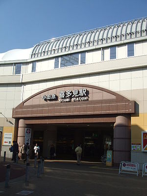
Kitami Station (Tokyo)
Railway station in Tokyo, Japan
Distance: Approx. 956 meters
Latitude and longitude: 35.6366,139.5871
Kitami Station (喜多見駅; Kitami-eki) is a minor stop on the Odakyu Electric Railway Odawara Line straddling the border between Setagaya Ward and Komae City in Tokyo, Japan. It is the 14th station, about 12.7 km (7.9 mi), from Shinjuku Station. It was used by an average of about 32,000 passengers daily in 2005.

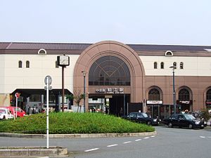
Komae Station
Railway station in Komae, Tokyo, Japan
Distance: Approx. 168 meters
Latitude and longitude: 35.6319,139.5771
Komae Station (狛江駅, Komae-eki) is a passenger railway station located in the city of Komae, Tokyo, Japan, operated by the private railway operator Odakyu Electric Railway.

Noborito
Distance: Approx. 1547 meters
Latitude and longitude: 35.62083333,139.57
Noborito (登戸) is a neighborhood in Tama-ku, Kawasaki, Kanagawa Prefecture, Japan just across the southwestern border of Tokyo on the Tama River and about 18 minutes south of Shinjuku on the Odakyu Odawara Line Express. In 1927, Odakyu Line and Nanbu Line were constructed. Noborito Station became the interchange station.

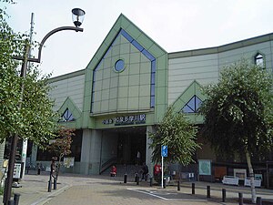
Izumi-Tamagawa Station
Railway station in Komae, Tokyo, Japan
Distance: Approx. 777 meters
Latitude and longitude: 35.6271,139.5736
Izumi-Tamagawa Station (和泉多摩川駅, Izumi-tamagawa-eki) is a passenger railway station located in the city of Komae, Tokyo, Japan, operated by the private railway operator Odakyu Electric Railway.

Shukugawara Station (Kanagawa)
Railway station in Kawasaki, Kanagawa Prefecture, Japan
Distance: Approx. 2020 meters
Latitude and longitude: 35.615333,139.579435
Shukugawara Station (宿河原駅, Shukugawara-eki) is a passenger railway station located in Tama-ku, Kawasaki, Kanagawa Prefecture, Japan, operated by the East Japan Railway Company (JR East).

Komae High School
High school in Tokyo, Japan
Distance: Approx. 878 meters
Latitude and longitude: 35.6274,139.571
Tokyo Metropolitan Komae High School (東京都立狛江高等学校, Tōkyō-toritsu Komae Kōtō-gakkō) is a public high school located in Komae, Tokyo, Japan. There are over 2000 male and female students at Komae from grades 10 to 12. The school was established on April 1, 1972.
Caritas Girls' Junior & Senior High School
School in Kawasaki, Kanagawa Prefecture, Japan
Distance: Approx. 1738 meters
Latitude and longitude: 35.6292,139.5588
Caritas Girls' Junior & Senior High School (カリタス女子中学高等学校, Karitasu Joshi Chūgakkō Kōtōgakkō, French: École secondaire Caritas) is a girls' private secondary school in Tama-ku, Kawasaki, Kanagawa Prefecture, Japan. Roman Catholic nuns from Quebec established the school in 1961.

Kitami Friendship Square
Park in Tokyo, Japan
Distance: Approx. 1361 meters
Latitude and longitude: 35.642,139.588
Kitami Friendship Square (きたみふれあい広場, Kitami fureai hiroba) is a park in Kitami, Setagaya, Tokyo. The total area is 38,824.83 m2. Kitami Friendship Square is built over an Odakyu Railway train maintenance facility.
Weather in this IP's area
overcast clouds
15 Celsius
15 Celsius
14 Celsius
17 Celsius
1022 hPa
87 %
1022 hPa
1018 hPa
10000 meters
4.49 m/s
9.11 m/s
38 degree
97 %
06:18:27
16:34:42

